

Beentee Loop Walk
LOCATION: Beentee, Cahersiveen
LENGTH: 10km
DIFFICULTY: Difficult
PARKING: Fair Green Car Park
A little bit about the area
Our map does not correspond to exact points or numbered signs. Instead, this map is seen as a companion for the area, filling you with information on what you might find and where you might find it. It will hopefully add to the enjoyment you gain from this wonderful corner of Iveragh and help build the memories that will stay with you long after you leave.
The white line follows the Beentee Loop - a 10km hiking trail following purple way-markers which can take around 4 hours to complete. There are a number of additional loops and trails around Beentee - which are accessible due to the generous permission of landowners. You can find out more via the South Kerry Development Partnership page - South Kerry Trails.
At 376m, Beentee hill overlooks the town of Cahersiveen and is a nice little challenge for those wanting to escape to the hills. The trail travels via a small section of native woodland to a farm section which includes lanes and narrow paths. Soon the route takes you along a strenuous upland trail which is very wet and boggy in sections. We encourage you to wear sturdy hiking boots, to be alert for deep bog holes and watch out for low clouds which may bring sea fog to higher ground. No dogs are permitted as this trail crosses land with farm animals
Have a look at Caherciveen.ie for more information on your stay in the area. There's plenty to do - from adventurous coastal activities to seafood dining. Head to the local book shop for maps and books on the region or take a walking tour of the town. Why not indulge in some of the locally made goods? From distilleries to handmade soaps - there are plenty of local businesses to support. If you are interested in the history of region, Walk of The Ancestors has some fascinating insights while this Frank Lewis podcast from Radio Kerry is a great audio story to immerse yourself into.
HOW TO EXPERIENCE THE MAPS:
The map locations can be seen on your mobile device. Clicking on the square icon in the top right hand corner of the respective map to open the map in a web browser or Google maps app. Or you can click on the square in the top left of the map to follow it on this page.
TRAIL GUIDE:
Below the maps is the guide for the map and the selected points.
There is also an alternative Storymap:
Beentee Loop Walk Guide
-
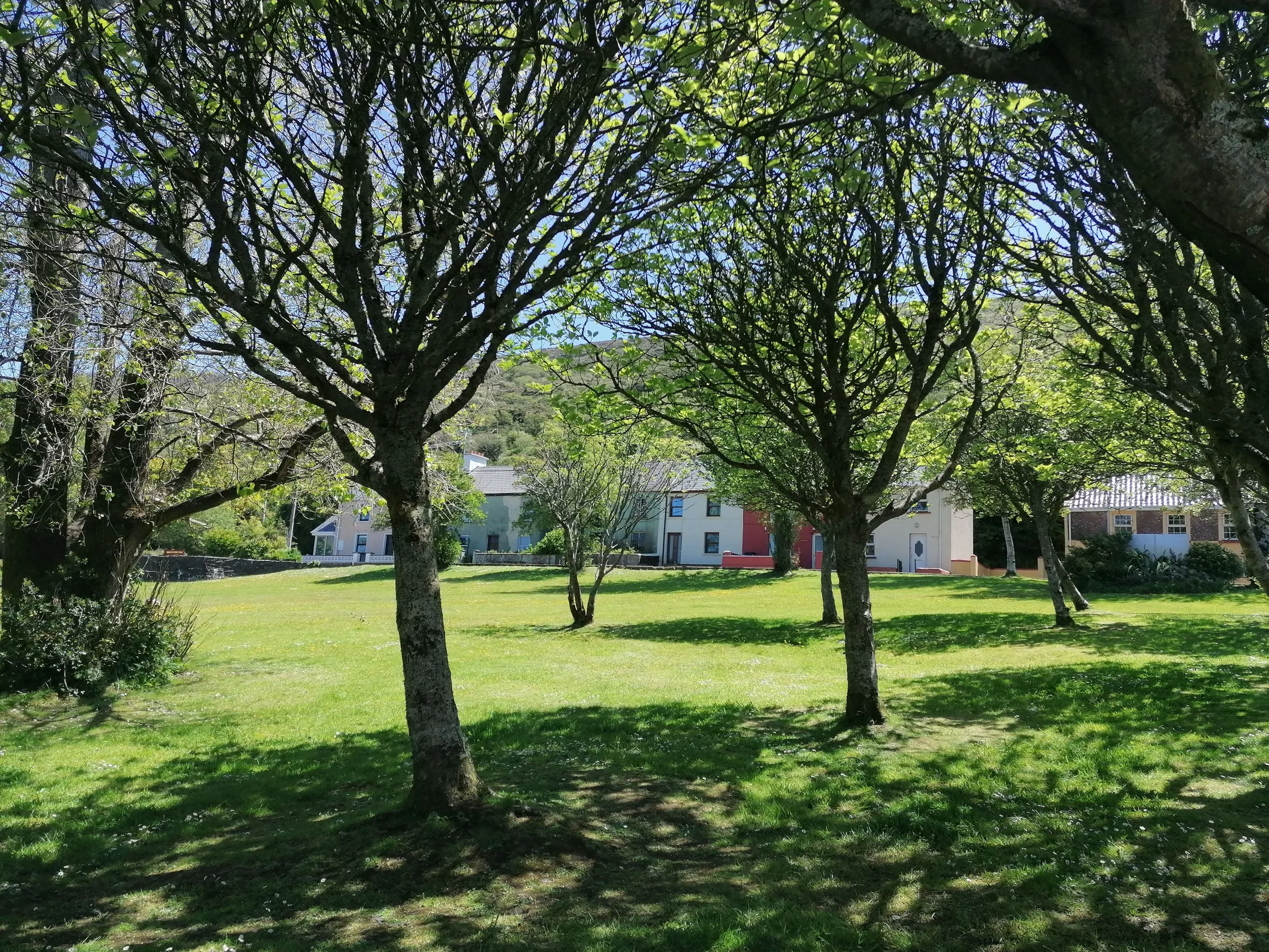
1. Start/Finish in the Fair Green
The Fair Green is an ideal start and end point for this loop where there are parking facilities and public toilets located just around the corner on Bridge Street. Among the wide range of shops, cafés and restaurants, you can pick up some food for the walk or maybe treat yourself on your return.
You start the loop by heading east on the residential road to the right of the Garda Station. The trail is marked from this point onwards with purple arrows, and travels in a clockwise direction. Please remember to Leave No Trace, pack out your rubbish and have a great time!
-

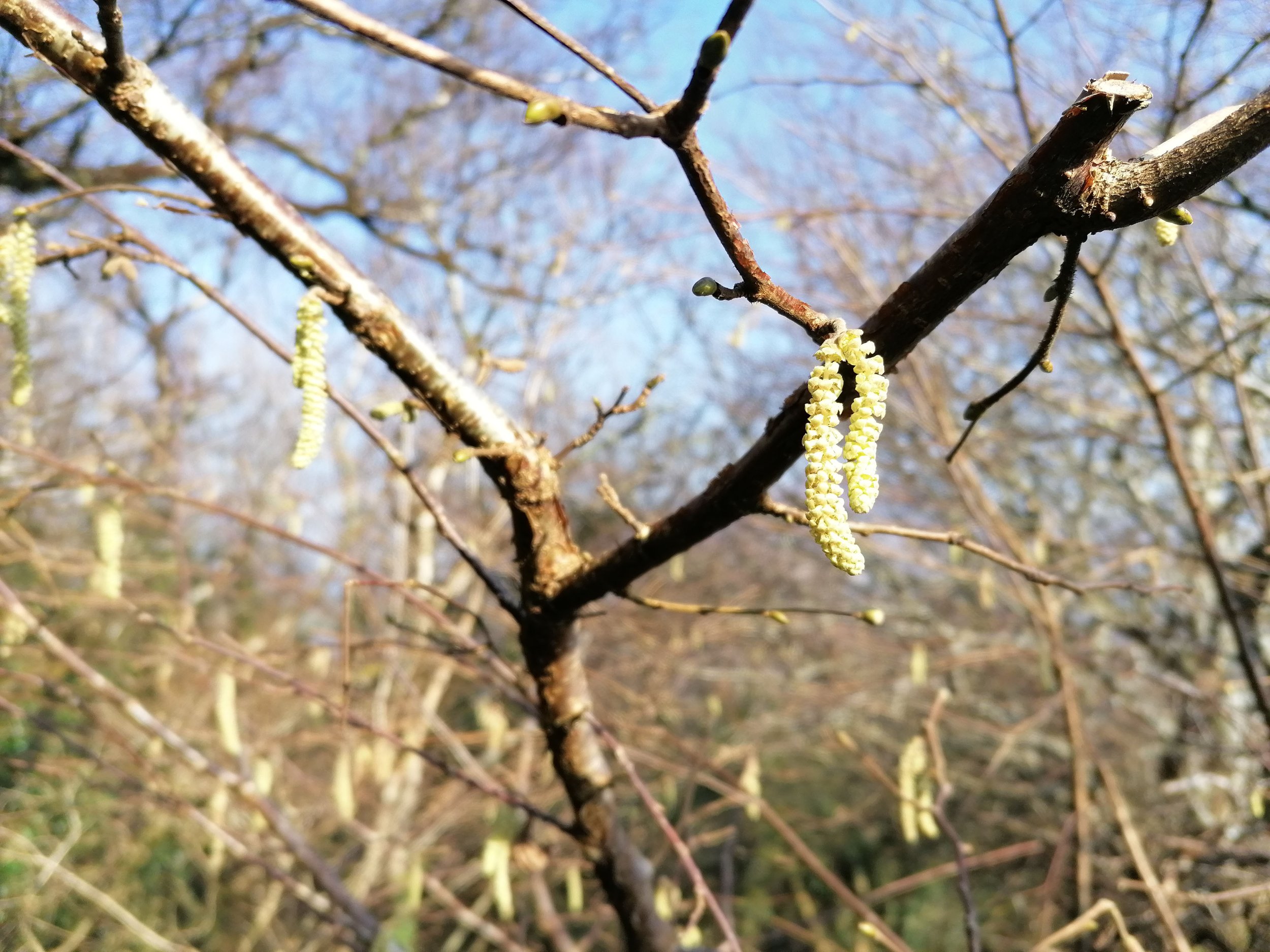
2. Native Woodland
Maybe it’s the sound of the wind in the treetops. Maybe it’s the smell of the soil after a shower of rain. Maybe it’s the shafts of light through the trees – described as ‘shivelight’ by Gerard Manley Hopkins. There is something quite magical about taking some ‘me time’ in a native woodland. It’s something that’s recognised in many cultures and in Japan they even have a name for it – ‘Shinrin-yoku’ or ‘Forest bathing’.
The start of the Beentee loop trails through Carhan Woods - a small section of mixed native wood with Holly (Cuilinn), Ash (Fuinseog) and Oak (Darach) among others. These small pockets are now scarce on Iveragh, which was once home to large swathes of native woodland. Autumn is especially beautiful in these woods. Golden leaves tumble in the breeze, vibrant red berries appear and acorns get tucked away by busy Red Squirrels (Iora Rua) or Jays (Scréachóg Choille).
The shapes of these fallen autumnal leaves can be a great way to identify trees. Combined with examining bark appearance, fruits, nuts and bud shapes in spring, putting species names to trees and shrubs is a great excuse to spend some extra time in the woods. The National Biodiversity Data Centre have some fabulous swatches – including one for the ID of trees and shrubs, both in English and as Gaeilge.
Autumn is also the perfect time to keep your eyes peeled for Fungi (Fungais). A seemingly endless variety of shapes and colours, you’ll soon realise that some are only found in certain areas or on specific trees. Read a little more about our fabulous fungi in our ‘Autumn on Iveragh’ or ‘Fungi – a kingdom unto themselves’ sections. Spring brings a welcome layer of colour to a post-winter woodland. Green shoots appear on the woodland floor, quickly followed by the yellows, whites, purples, of various flowers that emerge with the lengthening daylight. We’ve highlighted just how important our native woodlands are in our ‘Atlantic Rainforests’ section.
-

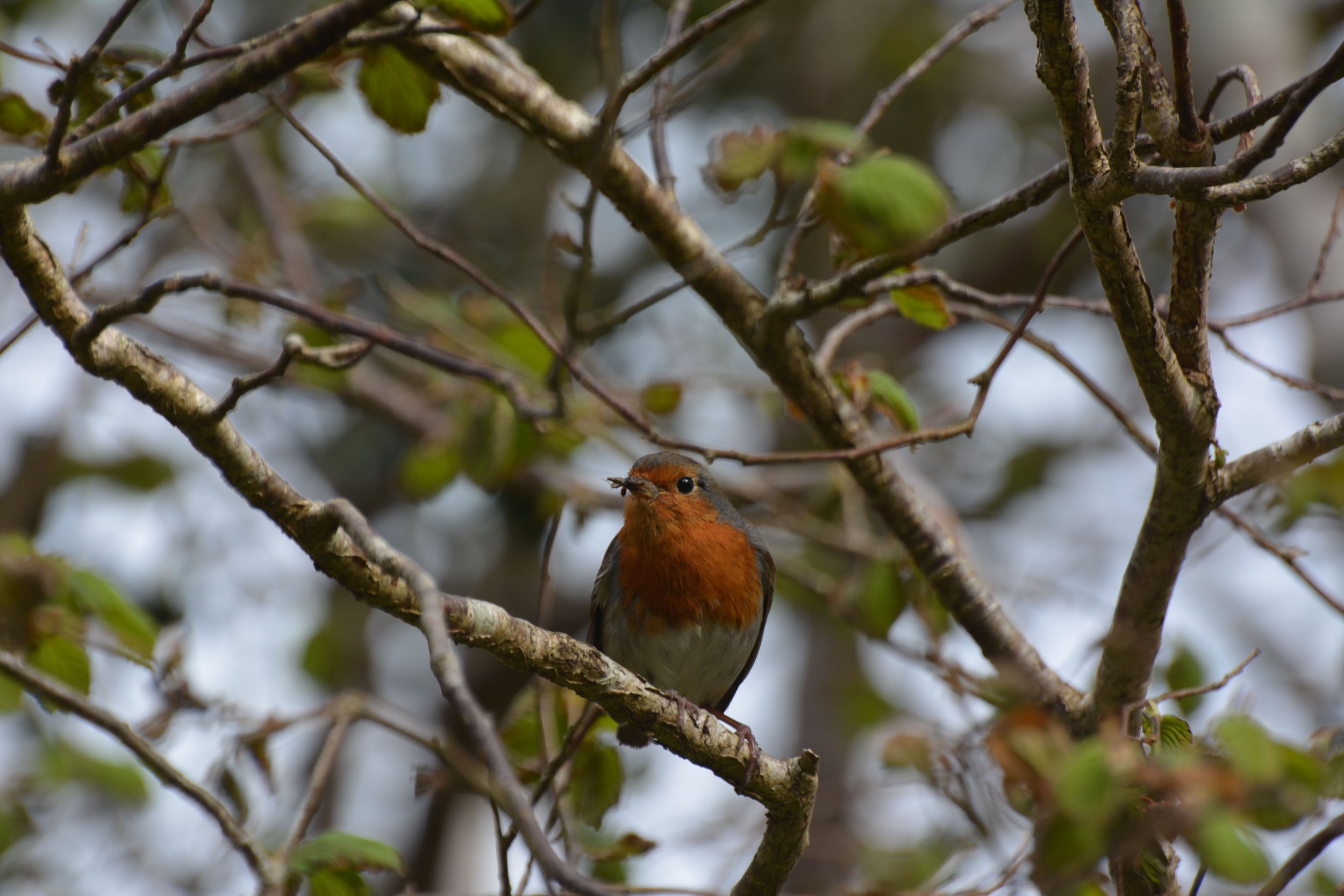
3. Woodland Birds
There is great joy to be had in being surrounded by woodland birdsong. The Robin (Spideog) is one of the few songbirds that regularly sings over winter, but they are joined by a host of others come spring. Dawn and dusk are the best times to hear them, although many lay claim to their territories or declare their mating intentions throughout the day.
One of the loudest of all happens to be one of our smallest – the Wren (Dreolín). This feisty character, with its upright tail feathers, is often heard exercising its vocal prowess from a hedge-top or tree branch. There is much to be said about just tuning out from the hustle and bustle of everyday life and tuning into birdsong. If you want to learn how to ID birds, their song is often a good place to begin. Try to learn one bird per week in spring – even a handful just to begin. Here is the call of the wren to start you off.
-

4. What's in a name?
Beentee come from the Irish ‘Binn tí’ or ‘Binn an tí’ meaning the ‘gable end’ or ‘top of the house’. As you approach Beentee and Cahersiveen from the east, you will see a ridge that follows along from a high point to the peak at Beentee. Perhaps the ridge looks like a roof connecting the two gable ends of a house?
We often learn so much more about a place by looking into the Irish name. Much of the detail is lost in the anglicised names. Take Cahersiveen for example or ‘Cathair Saidhbhín’ – ‘the fort of little Saidhbh’. Further exploration of this name will reveal Irish folklore of a dark sorcerer’s spell on a warrior princess who was the true love of Fionn Mac Cumhaill: Saidhbh (pronounced ‘Sive’). The fort of little Saidhbh is adjacent to the lovely Cahersiveen town park, next to the Old Barracks off Bridge Street. Logainm is a great website to search for information on the origin of Irish place names – have a look.
-

5. Mammals
We have many species of mammal on the Iveragh Peninsula but they are a secretive bunch so you may only catch the briefest glimpse. The fact that most of them are nocturnal is a factor, but it’s always worth being vigilant; when you do see one of our mammals it is an exciting moment.
One you might be lucky to see around Beentee is the Hare (Giorria). The hare you will see on Iveragh is the Irish Mountain Hare – Lepus timidus hibernicus – Ireland’s own native subspecies. Watch out for the females boxing away the attention of amorous males during springtime.
There is a rich folklore surrounding Ireland’s mammals. Niall Mac Coitir’s magical book ‘Ireland’s Animals: Myths, Legends and Folklore’ is a wonderful read. The stories of spells and shapeshifting is the perfect read with a mug of tea after a day on the hills.
6. Corvids
Crows (Préachán). Love them or hate them, we see them in urban and rural settings alike, but there is a lot more than meets the eye with these birds. Firstly, they are part of a group called Corvids. We have seven species here on Iveragh and you may well encounter all seven along the Beentee Loop Walk. One of the smaller corvids is the Jackdaw (Cág), their pale blue eyes standing out against the dark silvery black of the head feathers. Rooks (Rúcach) are extremely common; their noisy rookeries are easily located and along with the Hooded Crows - sometimes called Grey Crows - (Caróg Liath), they are two of our larger species of crow.
The largest of all is of course the truly breath-taking Raven (Fiach Dubh). More closely associated with cliffs and hilltops, their impressively deep croaking call is only matched by the size of their wing-span - which can be up to 1.5 meters! A rarer sight on Iveragh is that of the Jay (Scréachóg Choille). Preferring woodlands, they stand out from their relatives in that they are a light brown colour with a striking flash of blue feathers on their wings.
Magpies (Snag Breac) may be vilified by some but if we didn’t have them in Ireland and one arrived from a foreign land – we would surely flock (pardon the pun) to see their beauty. Next time you see a magpie, take a moment to really look at them. The contrasting black against crisp white; the iridescent feathers that reflect greens and blues; that diamond shaped tail-fan when in flight is a beautiful sight; a stunning bird.
Last, but by no means least, Iveragh is home to the Red-billed Chough (Cág Cosdearg). Iveragh is one of the few places in Ireland where you can see this bird, which spends most of its time along the coastline - but also ventures into upland areas. Their Irish name translates as ‘red legged jackdaw’. Their curved red bill are specialised for probing the soil for prey. Listen for their distinctive ‘keee-aaaww’ along the trail in spring and autumn, as it is one of their most important flocking grounds on the Iveragh Peninsula. You can find out more about our incredible Corvids here.

-

7. Stone Walls and Earth Banks
Ireland has over 400,000km of dry stone walls and 210,000km of stone-earth banks. Often of ancient origins, these boundaries crisscross the Iveragh, sometimes on the steepest hillsides or perilously close to cliff edges. Enclosing fields or following roadways, these banks and walls are important ecosystems for miniature flora and fauna. South-facing banks are also prime real estate for sun loving Common Lizards (Earc Luachra).
Tiny mammals such as Pygmy Shrews (Dallóg Fraoigh) make homes in cracks and crevices. Bumblebees (Bumbóg) utilise holes in these habitats and a host of critters such as Spiders (Damhán Alla) can be found weaving webs between gaps.
Mosses (Caonach) and Lichens (Léicean) drape over many surfaces, while Ferns (Raithneach) occur in many varieties. It may also be where you find your first spring Wildflowers (Bláth Fuáin) such as Lesser Celandine (Grán Arcáin) or Caterpillars (Bolb) munching on the Nettles (Neantóg) - a vital food source. In autumn, Brambles (Dris) take over - a welcome Blackberry (Sméar Dubh) feast for birds and walkers alike!
-

8. Peatland Habitats
Peatlands are important habitats for many species, but they are also vital carbon sinks. Maybe you have heard this term mentioned before but what does it actually mean? A simplified version of this process is that carbon dioxide (CO2) in our atmosphere can build up and increase the effects of climate change. Plants capture CO2 as they photosynthesise and plants are what form peat soils as they slowly break down over hundreds, or even thousands of years. Here in our bogs, plants hold onto this carbon, but if the peat from our bogs is drained, harvested and burned, it is released back into the atmosphere.
The International Union for Conservation of Nature (IUCN) states that peatlands store more carbon than any other vegetation – including all the world’s forests combined. Therefore, it is really critical that peatlands are protected and preserved to mitigate the effects of climate change. Ireland is home to both raised bogs and blanket bogs. Here on Iveragh, we have only blanket bogs, which can be further divided into two types: ‘Atlantic blanket bog’ and ‘mountain blanket bog’ – the latter of which is found around Beentee.
Occurring in upland areas with high rainfall and low evaporation, mountain blanket bogs are home to Frogs (Frogs), Newts (Earc Sléibhe) and Lizards (Laghairt Choiteann) as well as a large number of invertebrates such as Butterflies (Féileacán) and Spiders (Damhán Alla). The Irish Peatland Conservation Council (IPCC) has some excellent information on a variety of wildlife associated with bogs, as well as community-driven restoration projects. Visit our section on blanket bogs to learn more about these vitally important habitats.
-

9. Peatland Habitats: Flora
Many of the flora found in bogs have special adaptations – take the carnivorous plants for example. Yep, that’s right, plants that eat things like insects! Bladderworts, Butterworts and Sundews are plants which trap and digest hapless insects – often luring them in with a sticky, sweet substance.
Lesser Bladderworts (Lus Borraigh Beag) take their name from ‘bladder-like’ structures which grow on these aquatic plants. As a plant without roots, it floats in shallow pools and streams, producing a yellow flower in June and July. Sensitive hairs around the bladders are brushed by passing invertebrates which, in turn, triggers the bladder to contract – the resulting vacuum sucks the prey into the bladder, where it becomes trapped and doomed to its fate.
There are three species of butterworts – Common Butterwort (Bodán Meascáin), Large-flowered Butterwort (Leith Uisce) and Pale Butterwort (Leith Uisce Beag). All three attract their prey with a buttery oil on their leaves, which then curl over to capture the victim within. Digestive juices are produced to reduce the prey to valuable nutrients for the plant to absorb.
A similar process occurs in the Sundew plants – of which we have two: the Round-leaved (Drúchtín Móna) and the Oblong-leaved (Cailís Mhuire). A sticky substance, irresistible to some, becomes their last meal. When digestion is complete, the plant unfurls its trap again, the wind blowing free any undigested remains. Learn more about these fascinating plants here.
-

10. Peatland Habitats: Birds
You may be familiar with some of the feathered visitors to bogs, while others are less well known. Early spring is when they make themselves more conspicuous: the seemingly endless virtuoso performance of a Skylark (Fuiseog) calling high above the ground (video), the Meadow Pipit (Riabhóg Mhóna) with their ever-rising flight call which results in a winged parachute back to earth, or the ‘track-track-track’ of the Stonechat (Caislín Cloch) from atop the reeds.
A more surprising sight might be that of the elusive Red Grouse (Cearc Fhraoigh). A red-listed species in terms of conservation status – our most at risk level – the sight of one of these birds is becoming more and more rare. A very secretive upland bird, early spring is again the best time to see them or hear the males make their unusual clacking mating call.
Heather (Fraoch) is a vital food source for these birds, as well as providing shelter for their ground nests. In fact, the dense low blankets of heather and Gorse (Aiteann) on upland areas are an incredibly important habitat for many species. Curlew (Crotach), Lapwing (Pilibín), Hen Harrier (Cromán na gCearc), to name but a few, all require peatlands for food and shelter.
While we may associate curlew with wetlands, especially in winter, when it comes time to breed those that have overwintered as visitors to Iveragh will move north to their homelands. However, a few very special pairs will move to our uplands to make their nests and raise their young. These are a dwindling few, another name added to our red list, but people such as the Curlew Conservation Project are working hard to give these vital Irish breeding pairs a fighting chance at survival. Don’t forget to let them know if you see or hear curlew in our uplands during the breeding season, but make sure to keep your distance to avoid disturbing them during this crucial period. Learn more about these birds here.
-

11. Mountain Building
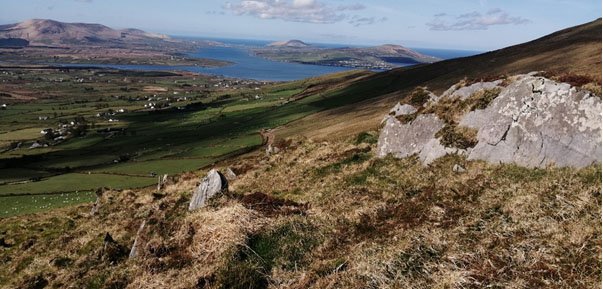
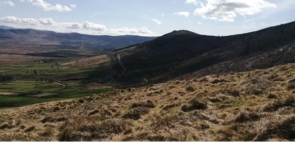
Beentee Mountain is the product of a collision of tectonic plates that occurred around 318 to 290 million years ago. When these continental plates collided, Iveragh’s previously flat layers of rock were squeezed with such intensity that they were lifted upwards and folded to form a series of mountain chains. The top of Beentee is an excellent place to take in Iveragh’s landscape of ridges and valleys, with the expansive valley spanning from Cahersiveen to Kells enclosed by impressive ridges on almost all sides.
During the mountain building event, the rocks were also cracked and fractured under the immense pressure of the colliding continents. One of these large-scale fractures, known as a fault, runs along the River Ferta and across to Glanleam on Valentia Island. The presence of this fault created a low-lying area which allows for the remarkably straight course of the River Ferta as it flows past Cahersiveen.
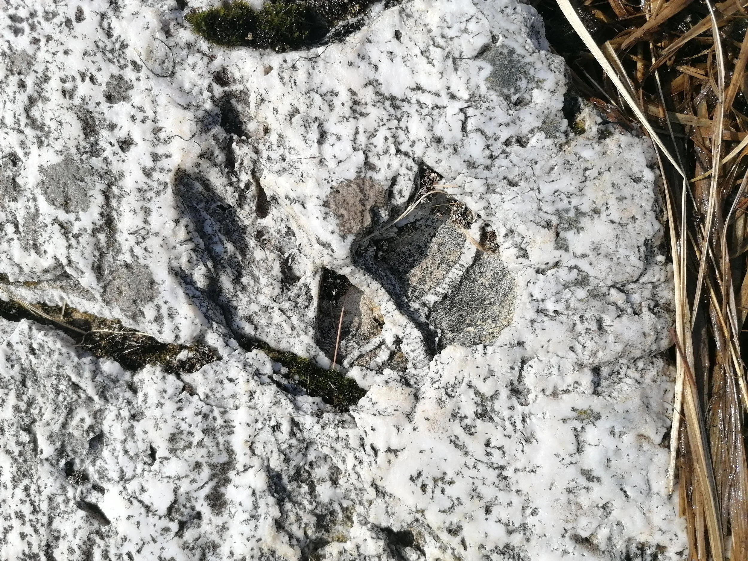
Hot fluids from deep within the earth seeped into some of the smaller fractures and cracks, and as they cooled, this created mineral quartz veins and sheets you can see cutting across the rocks.
-
12. Beentee Geology
The rocks seen across the Beentee Loop were originally deposited between 393 to 380 million years ago. During this time Ireland was situated just south of the equator in a much hotter environment than today. At the time, what is now Cahersiveen would have been located over 200km from the sea: a big contrast to the coastal environment of today.
The area around Iveragh was a low-lying floodplain and river channels and floods carried sediment such as sand, silt, and pebbles down from high land in the north and deposited them within this low-lying area known as the Munster Basin. Plant and animal life during this time was quite sparse. Although the first trees were beginning to appear and smaller plants similar to ferns and horsetails were common, these were concentrated in the wetter areas along river channels and lakes. The absence of grass, coupled with the low cover and diversity of vegetation means that the area would have appeared rather barren. Animal life was even further restricted and was dominated by insects and scorpion-like creatures.
As layers of this sediment built up, they were gradually compressed and solidified into hard rock. The rocks on Beentee are commonly purple and green siltstones and sandstones which belong to the Old Red Sandstone Formation. The original depositional layers can still be seen in some of the exposed rocks scattered across Beentee.
Over millions of years, layers of sediment continued to build up and were compressed and solidified into hard rock by the overlying weight. Layers of rock with uniform sediment compositions and textures are known as ‘beds’ and represent different depositional events, such as individual floods or changes in the sediment supply of rivers. Different depositional events can be distinguished by variations in sediment size or colour, and many beds can still be seen in some of the exposed rocks scattered across Beentee. The boundary between each bed represents periods where no deposition took place, which may comprise timescales spanning from years to centuries. The rocks on Beentee are commonly purple and green siltstones and sandstones which belong to the Old Red Sandstone Formation. For more on Iveragh’s fascinating geological history, visit our geology section.
13. Glaciation
On the northeast slope of Beentee you may notice that a large scoop appears to be missing from the side of the mountain. This hollow was created by glacial ice during the Ice Age. The Ice Age began around 2.6 million years ago and during this time Iveragh was covered by ice on several different occasions. This feature on Beentee is known as a ‘corrie’ and was likely eroded away during the most recent glacial period which began around 24,000 years ago.
Corries form when snow builds up in pre-existing hollows in mountain sides. Once enough snow builds up, it is compressed into glacial ice and forms a glacier. As the glacier flows down the mountain it erodes and enlarges the original hole, until it becomes a large amphitheatre shaped hollow. The word Corrie has its origins in the Irish word 'coire' which means a large pot or cauldron. Corries are also referred to as ‘cirques’ or ‘cooms’, with ‘coom’ (com) appearing frequently in place names across Iveragh.

-

14. River Ferta and Estuary
At various point on Beentee, you will see parts of the River Ferta Estuary below. The river rises in Ireland’s largest mountain range - the MacGillycuddy’s Reeks - which lies to the east and flows for around 16km before reaching the sea at Valentia Harbour. The estuary is a great place for bird watching, especially from September to April when many species of wetland birds arrive to Ireland. These birds arrive from northern latitudes, where the weather is much colder, to enjoy our milder winters. The iconic call of the Curlew (Crotach) may be heard on the wind, while closer inspection may reveal some more unusual visitors such as the Spoonbill (Leitheadach). Kerry Birds is a great resource to keep an eye on – with Iveragh’s many skilled birders updating unusual sightings.
There are a couple of locations to get a better view of river wildlife in the area. The first is Cahersiveen Town Park, where benches and landscaped gardens make for a relaxing spot to take time out. Watch out for Seals (Rón) following the turning tides, a loud exhale of air on resurfacing from a dive is often the first sign of their presence.
The second spot is the Daniel O’Connell Memorial Park, located at the Carhan Bridge around 1km east of Cahersiveen. This is a tributary of the Ferta, and the park has great views and if you are really lucky you may see An Madra Uisce, the water dog, or Eurasian Otter. Otters love to forage along estuaries and rivers, and some will even venture further offshore, ducking and diving in coastal waves while searching for Crabs (Portán) or Fish (Iasc). You can find out more about Iveragh’s otters in our other wildlife section. In Cahersiveen, you can also engage in sea sports, which are another great way to experience the River Ferta.
-

15. Valentia Observatory
At the top of Beentee you will find two important structures. One is an inviting bench for you to take a break, maybe enjoy that flask of tea you packed, and take in the spectacular 360˚ views of the surrounding region. The second, is a Met Éireann Data Relay Site.
The Valentia Meteorological Observatory has been a hugely important asset to Iveragh, Ireland, and to Europe since first beginning operations in 1860. As one of the most westerly points in Europe, the weather station continues to be a crucial link in monitoring the weather systems coming in from the Atlantic.
Although originally based on Valentia Island, the station moved to its current location one kilometre west of Cahersiveen in 1892. Here, the Observatory’s tall instrumentation and beautiful Westwood House can now be seen from the top of Beentee. Data Relay Sites at upland locations such as Beentee, help monitor the upper atmosphere and you might also witness the odd weather balloon rising from the weather station below.
As well as providing us with weather forecasts and climate predictions, the observatory also holds one of the longest running phenological data sets in Ireland. Phenology is the study of nature’s calendar – seasonal events in trees and plants such as bud breaking or flower emergence to wildlife cycles such as bird migration or nest building. Recordings of these events help us monitor biological cycles such as those effected by climate change. Valentia Observatory and the National Botanical Gardens in Dublin recently produced a report detailing some of their observations which you can read here. Alongside their phenological garden, staff at Valentia Observatory have also taken steps to bring hay meadows back to the site; these flower-rich meadows are a hugely important habitat for wildlife in the local area.
-

16. View from the Top
As we mentioned already, the panoramic views from the top of Beentee are breath-taking. Look to the east and you will see the MacGillycuddy’s Reeks mountain range, which is home to Ireland’s tallest mountain: Carrauntoohil (Corrán Tuathail). Looking north-east, you can follow the hills along what is the south coast of Castlemaine Harbour. Many were pilgrimages, including Drung Hill near Glenbeigh, and Cnoc na dTobar (Hill of the Wells) where you have wonderful views of Beentee. The spine of the hill rises along one of Ireland’s Pilgrim Paths to the peak at 690m. On a clear day, you might see the white cross at the summit. The pilgrimage route was revitalised by Cannon Brosnan in 1885 when points marking the stations of the cross were erected along the route. It can be climbed at any time of the year, but the pilgrimage gathering usually takes place on the last Sunday in July.
West of Cnoc na dTobar, you will see Castlequin Hill, Kimego Forest and Doulus Head. The foreground of these hills is locally known as ‘Over the Water’ owing to the separation of these lands from Cahersiveen town by the River Ferta. Barry’s Bridge (named after a local Dr Barry who contributed funds to the building of the bridge) can be seen next to the old railway bridge and the Old Barracks. Cahersiveen Marina can also be picked out of the townscape, where water-based activities can be booked to experience this lovely part of town.
Continuing west will take you to Valentia Harbour including Beginish (Beiginis, meaning ‘small island’) and Valentia Island (Dairbhre). Boat trips around Valentia Harbour and Beginish can be arranged and offer great insights into the area’s history, geology and importance to wildlife. Beyond the northern tip of Valentia Island, you will see Dingle Bay and the Dingle Peninsula. On a clear day you may catch a glimpse of the Skellig Islands on the horizon to the west. Scanning further south-west reveals much more of Iveragh, including Ballinskelligs Bay, Hog’s Head and maybe even the Beara Peninsula in the distance.
There are many more walking trails across Iveragh to explore. Have a look at South Kerry Trails for more info.
-

17. Historic Sites
Looking north-west from the vantage points on Beentee you may see some of the large historic sites which give clues to the long history of this region. The ruins of Ballycarbery Castle stand on a small hill at the western end of the Ferta estuary. Built in the 15th century by Carbery O’Shea, the castle was likely a fortress to defend the area given that it had 9ft thick walls and narrow window slits for archers to launch their arrows.
The castle moved into the ownership of the McCarthy Mór clan before being occupied by the O’Connell family – ancestors of Daniel O’Connell. Cromwellian cannon fire caused extensive damage to the castle during invasions in 1652. Unfortunately, the castle ruins crumbled further over the years, but it is still a reminder of the turbulent history of the area.
A bit trickier to see from Beentee are the Cahergall (7th century) and Leacanabuaile (9th century) stone forts. These impressive stone structures hark back to more ancient times on the Iveragh Peninsula. Both forts had high defence walls around smaller dwellings within. Exactly who built them and why is unknown, but it could be assumed that the high ground and size of the Cahergall fort may hint at someone of a high standing. Once again, the original Irish names can give us valuable information on such sites: Leacanabuaile comes from ‘Leaca na Buaile’ or ‘Hillside Booley’, with booleying being the term for moving cattle from high ground to lower coastal grazing with the seasons. Dr Eugene Costello, of University College Cork, has studied this farming practice in great detail and you can watch his fascinating talk on the topic with the Irish Wildlife Trust here.
-

18. Iveragh Railway
One of the most conspicuous structures on the landscape looking down from the heights of Beentee is the old railway bridge crossing the Ferta estuary. Opened in 1893, the bridge was a key part of the 40-mile long Iveragh railway service.
The current railway station in Farranfore had a connection west, stopping at Molahiffe - Castlemaine – Milltown – Killorglin – Caragh Lake – Dooks - Glenbeigh – Mountain Stage – Kells - Cahersiveen – and the Valentia Island terminus. The Great Southern & Western Railway Company operated the service, which was the most westerly railway in Europe, from 1890 to 1960.
Most of the evidence of the railway is long gone or disused but the bridge in Cahersiveen, the viaducts in Gleensk and Killorglin, and a brief glimpse of hill tunnels (along the Mountain Stage to Kells section) are a few of the more iconic reminders of this once bustling rail route. Plans are afoot for converting part of the route into a Greenway for cycling and walking, reconnecting the Glenbeigh to Cahersiveen section.
Cahersiveen Town Park is located next to the Old Barracks and is a wonderful place to get great views of the old rail bridge and check out some great information signage.
-

19. Cahersiveen Town
There is a long and complex history around Iveragh and the Cahersiveen area. The Barony of Iveragh was gifted to Trinity College Dublin in a royal grant in 1597. Various landlords and middlemen controlled sections of the 8,808 acres of land, including the O’Connell family. Daniel O’Connell was born in Cahersiveen before the family moved to Derrynane.
There was conflict and controversy about how lands were managed and in 1865, Trinity took back control of the rent management. From around this time onwards, Iveragh began to prosper and the town of Cahersiveen began to grow – particularly with the arrival of the railway in 1892.
Of course, there is far more detail to be found here – from large markets and fair days, Fenian uprisings and rebellions, along with seafaring tales of the seas surrounding Iveragh. Walk of the Ancestors has some incredible detail in the research completed by the Golden family from nearby Kells. The Old Barracks is a great way to take in the local history and is well worth a visit.