

Coastal Geology of Iveragh
The Iveragh Peninsula has a remarkable stretch of coastline that is well known for its spectacular scenery and dramatic contrasts. Iveragh is surrounded by ocean on three sides, bound to the north by Dingle Bay and to the south by Kenmare Bay. Around the coast, the setting varies considerably from ravaged and wave-beaten rocky shores, long sandy beaches, sheltered coves, and steep precipitous cliffs.
Coastlines are highly dynamic regions that are eroded and built up by the force of the ocean to form an enormous range of impressive and inspiring landforms. Winds, currents, weather, vegetation, gravity, and human influences all shape the land along the coast, however, the most powerful agent of change along the Iveragh coastline is undoubtedly the daily battering of the sea. Waves have an unparalleled capacity to erode, transport, and deposit large volumes of rock and sediment.
Waves form as the wind blows across the sea and form a swell. Wave strength and height depend on the wave fetch, which is the distance that the wind blows across the water, the wind speed, and wind duration. As waves approach the land, they break. When a wave breaks, the water that rushes up the shore is known as swash, and the water that flows back towards the sea is called backwash. Waves can either be constructive or destructive and this is largely determined by the relative strength of the swash and backwash. Destructive waves have stronger backwash than swash so they pull material away from the shoreline, resulting in erosion. Destructive waves generally have large fetches, high energy, and are big and steep. Constructive waves have stronger swash than backwash so they deposit material on the shoreline. Constructive waves are less powerful and smaller than destructive waves.
Coastal Erosion
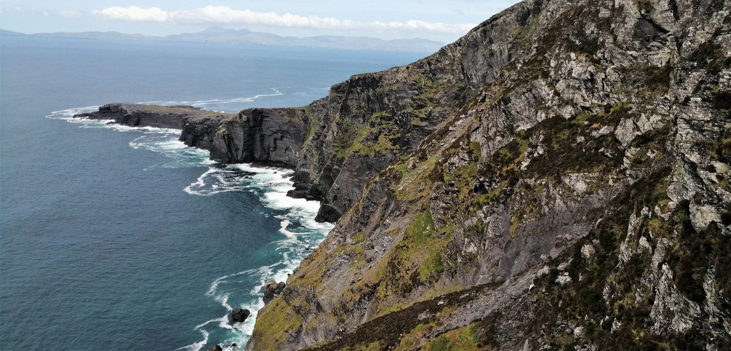
Iveragh has a dominantly rocky coastline, which is characteristic of areas that face persistent erosion from high energy waves and gale-force winds. For thousands of years following the last glacial period, the Atlantic Ocean has worked against the rocks of Iveragh’s coast, exploiting variations in rock hardness, orientation and seeking out zones of weaknesses created by fractures and faults. The elevation of Iveragh’s coastline fluctuates greatly, from the towering Kerry Cliffs to the many low-lying bays and strands. This extreme variation partially depends on the strength of the rock, as more resistant rocks tend to create steep gradients. However, on the Iveragh Peninsula, the coastal profile is largely an extension of the overall topography and the positions of the mountains and valleys that punctuate the region.
Rocky coastlines host many spectacular erosive features and while these features may seem unmoving and permanent, they are fleeting configurations that will eventually disappear as the relentless cycle of erosion continues. Although the landforms are very young, geological speaking, to truly appreciate these landmarks it is important to understand that the coastline of today began its evolution over 380 million years ago.
-

Bays and Headlands
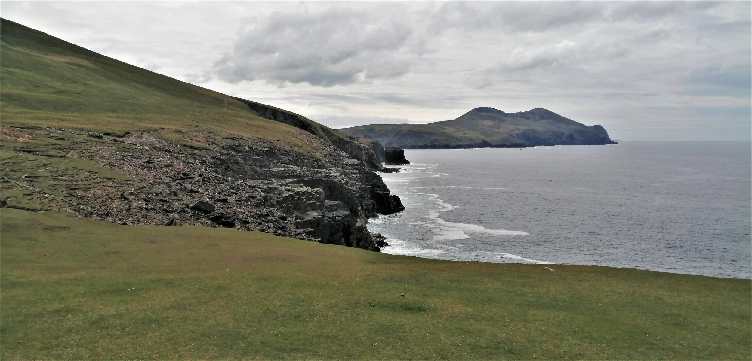
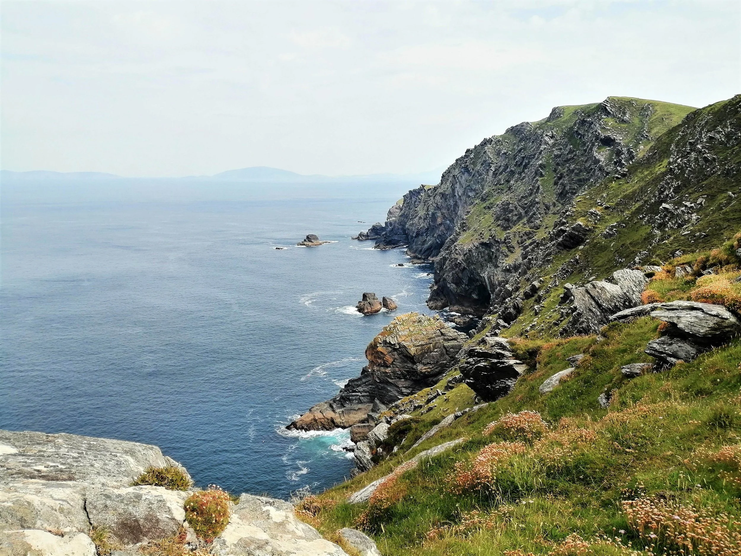
The western coast of Iveragh is heavily serrated by inlets, bays, and headlands. Bays and headlands form because the sea erodes areas of rock at different speeds. This variation is usually due to the presence of different rock types, for example, igneous rocks tend to be harder and more resistant to weathering and erosion, while sedimentary rocks are usually softer and so weather and erode more readily. Slight variations within rock types also result in variable erosion, such as those found within the sedimentary Old Red Sandstones that dominate Iveragh. Structural weaknesses within the rock, such as faults, fractures, and cracks within the rock itself can also cause the formation of bays and headlands. When waves attack a section of coastline, the softer or weaker areas of rock are eroded, carving out bays while the harder and more resistant rocks protrude out as headlands.
-

Rocky shore
Across Iveragh, many of the shorelines are composed of rocky outcrops that lack significant beach deposits. Rocky shorelines are highly irregular with jagged rock platforms, wave flung boulders, rock pools, and much coastal erosion and weathering.
Explore any of Iveragh’s rocky shores and you are likely to be drawn towards the unusual and mesmerising patterns created by weathering and erosion. The rocks of the shore often show substantial variation across a small area. One moment the rocks may appear colourful and smooth, the next, blackened and heavily corroded.
Erosion along the shoreline is largely driven by wave action, but currents and tides also play a significant role. A particularly common feature is areas of rock that appear smooth and undulating. This type of rock surface is formed by abrasion. Abrasion occurs when pebbles and sand carried by the waves and tides grind over the rock surface like sandpaper, gradually smoothing the rock. When pebbles enter a small depression in the rock, the water may flow in a swirling pattern, carving out smoothed hollows.
Weathering occurs when the rock structure is weakened by the elements and is broken down into smaller pieces. Weathering can be mechanical, chemical, or biological and involves processes such as alternate wetting and drying, frost action, and salt crystallisation. Chemical weathering occurs as the structure of the rock is altered by interaction with the rainwater or seawater that gets into cracks or holes in the rocks. As this water can be weakly acidic, over time the rocks can dissolve. In many areas, the rocks appear heavily corroded or punctuated with numerous holes due to this chemical weathering.
Rockpools form when the areas between high and low tide are alternately submerged and exposed to the air throughout the day. Natural depressions fill with seawater and these rocky intertidal pools create a unique, rich, and biodiverse marine environment.
Landforms of Coastal Erosion
Below some of the most distinctive landforms of erosion found on the Iveragh Peninsula are outlined. Many of these features are best seen from the water and there are a host of boat tour providers that explore Iveragh’s coast. You can explore some of Kerry’s boat tour providers here. However, here we have focused on the best locations to appreciate the coastline from the land.
-
Cliffs
Sea cliffs are steep faces of rock that form through the repeated action of waves crashing against the coastline. Cliffs form as the base of coastal rocks are attacked by waves, carving a wave-cut notch between the high and low watermark. As this notch grows larger, the overlying rock becomes destabilised, resulting in slope failure and collapse. As this process continues cliffs retreat further, leaving behind wave-cut platforms that may extend for hundreds of metres in front of the cliff.
Iveragh possesses spectacular coastal cliff scenery across a range of scales. The vertical cliffs of Iveragh are striking for their combination of coloured layers of Old Red Sandstones, which range from grey-green to purple and red. These layers provide a record of millions of years of Earth’s environmental and climatic history. Imagine the vast amount of time required to build these formidable rock layers. These cliffs often expose classic deformation structures, such as folds, that formed as the rocks crumbled under the immense mountain building forces.
Iveragh’s highest cliffs, the Kerry Cliffs, rise a vertiginous 305m above sea level. At Valentia Island, the Fogher Cliffs plunge around 180m into the Atlantic from the northern face of Geokaun Mountain. The more moderately sized Abbey Island cliffs in Derrynane are equally worth a visit.
-

Sea Caves
Sea caves are large holes or tunnels found at the foot of a cliff. These again form through the action of waves hurling against the rock and exploiting weak spots in the cliff. Over repeated cycles of wave pounding, these eroded hollows expand, becoming dark and alluring caverns. Caves are common on the sides of headlands, where erosion tends to be focused due to wave refraction around the headlands.
Among the best place to see caves are Cooncrome (Irish: Cuas Crom) and Coonanna Harbour, both located ‘over the water’ from Cahersiveen. The numerous small caves and inlet found at these coves, were undoubtedly influential in the naming of the site, with ‘cuas’, translating as cave in Irish
-

Arches
Sea arches are natural archways in rocky headlands. These form when a cave erodes all the way through a headland or when two caves erode through a headland on either side.
Sea arches can be quite difficult to see from the land but on the road leading from Cuas Crom to Kimego, an isolated sea stack protrudes out into the sea, surrounded by the evidence of previous rock collapses, in the form of large boulders scattered across the shoreline. A sea arch can also be seen towards the southern end of Bray Head.
-
Sea Stacks
Sea stacks are pillars of rock that stick out of the sea and are often found near headlands and islands. Sea stacks form when the roof of a sea arch collapses, following years of ongoing weathering and erosion and the outer wall is isolated as a steep column of rock.
A prominent sea stack can be seen in the distance from the Canglass Blowhole, near Kimego.
-
Sea Stumps
Sea stacks are attacked further by the weathering and erosion and will eventually collapse as waves continue to attack the base. All that remains of many former sea arches and stacks are low projections of rocks called sea stumps.
Sea stumps are found in profusion at the base of the towering Kerry Cliffs and at Bray Head, where they serve as a reminder of the mutability of the coastline.
-

Blowholes
A blowhole is a hole or tunnel that joins the roof of a cave with the land surface above. These features initially form as sea caves. When sea caves grow upwards and landwards to form vertical shafts, they may eventually become exposed at the surface when the overlying rock roof collapse. Normally this collapse happens progressively from the cliff face, but blowholes form on the rarer occasions where the roof falls further into the cave.
A large blowhole is found at Canglas near Kimego. Within the exposed walls of the pit here, the original depositional layers of the Old Red Sandstones are still visible. Eventually, the arch forming the coastal limit will collapse, leaving behind an inlet.
Landforms of coastal deposition
Coastal deposition occurs when waves slow down and lose energy, causing the sea to drop or deposit the sediments it had been transporting. The major landforms of coastal deposition are beaches, spits, bars, and tombolos.
-

Beaches
Beaches are amongst the best-known coastal features and show considerable variation in form, depending on the shape of the coastline, the local geology, and the prevailing weather conditions. A beach is an accumulation of materials such as sand, gravel, and pebbles on the seashore between high tide and low tide levels.
Most sandy beaches are formed in shallow waters on gently sloping shores, where incoming waves have low energies. These waves are generally constructive, with powerful swashes that push the beach material up the wide shore. As the waves spread out over the shore, much of their water soaks into the sandy or pebbly ground. This results in weak backwashes, with sediments deposited rather than removed from the shore. Some of Iveragh’s sandy beaches are found at Ballinskelligs Strand and Reenroe and Inny.
Contrastingly, pebble beaches tend to form where cliffs are actively eroded, and wave energy is high. Across Iveragh many of the beaches have large pebble size material at the top of the beach. This larger material was thrown up the beach during high-energy storm events. The beach at Waterville is a superb example of a storm beach and is almost completely covered by large pebble to boulder-sized material and has a very steep gradient.
Many of the beaches around Iveragh are pocket beaches that occupy small bays, nestled between rocky outcrops. Once formed, headlands shelter bays and themselves become more vulnerable to erosion. The limited energy waves entering these bays cause beach material to be deposited within these pockets forming curved sandy beaches.
Pocket beaches are found at Glanleam, St. Finian’s Bay, Kells, and Glanbeg.
-

Sand Spits
A sand spit is a long narrow ridge of sand or shingle extending out from the coast, where one end is joined to the land and the other terminates in the sea. Sand spits form through longshore drift. In longshore drift, the sediment is pushed onto the beaches at an angle of about 45 degrees by the swash. The backwash then drags the material straight back towards the sea at right angles to the coast. Through this process, the material is transported in a zig-zag pattern across the shore. When the coast changes direction, this process continues, and material is deposited as a thin strip extending out from the coastline. Sand spits are often also found near estuaries, where deposition can be brought about earlier because the flow of water from rivers into the sea is stronger than the drift, resulting in sediment deposition and accumulation which can gradually form a spit.
Rossbeigh Beach is an excellent example of a sand spit on the Iveragh Peninsula and projects outwards from Glenbeigh. The presence of the sandspit at Rossbeigh is closely related to the influx of water from the River Caragh and River Behy, as they drain into Dingle Bay. The Rossbeigh sandspit and its dune system act as an important protective barrier for the Castlemaine Harbour area. This is a Special Protection Area and Special Area of Conservation with a range of critically important habitats including tidal mudflats, sandflats, and dunes, and hosts a large population of protected bird species.
-

Sand Bars
A sand bar or bay mouth bar is a narrow ridge of sand or shingle that extends partially or entirely across the mouth of a bay. It usually formed when a spit extends across a bay or an estuary and cuts it off from the sea.
A sand bar is found at Derrynane, which almost fully encloses the bay to form a lagoon. The Derrynane Seashore Nature Trail, created by environmentalist and multimedia artist Vincent Hyland, explores the dune system and the area behind the sand bar at Derrynane.
-

Tombolos
A tombolo is a ridge of sand or shingle that joins a former offshore island to the mainland or another island. A tombolo is formed when a spit grows in length until its seaward side reaches a nearby island. Tombolos tend to form because the sheltering presence of the island creates an area of slow-moving, low-energy water behind the island which favours sediment deposition.
A short tombolo connects Abbey Island to the mainland at Derrynane and another tombolo connects Beginish Island to the smaller Church Island to the east.
Islands of Iveragh
Some of Iveragh's most impressive coastal features are not products of erosion or deposition but the numerous islands scattered along the coast. These islands vary considerably in size, ranging from the 10.5 km length of Valentia Island to the countless islets with lengths of less than 100m. The islands of Iveragh are mostly peaks of hills and mountains that formed around 290 million years ago, at the same time as the mountains that can be seen across the peninsula including the Dunkerron Range and the Macguillycuddy’s Reeks. At the time of formation, these peaks would have remained attached to the mainland, separated by only valleys and low-lying land.
Jumping forward to the last glacial period, around 25,000 years ago, much of Iveragh was buried beneath thick sheets of ice. As so much water was locked up in ice sheets across the northern hemisphere, the global sea level was about 120m below present. However, by about 14,000 years ago these ice sheets had largely melted and retreated from lowland regions and a huge influx of meltwater drained into our oceans, causing rapid sea-level rise. It was during this sea-level rise that the islands of Iveragh were isolated, as rising seas flooded low-lying areas, leaving only the highest peaks rising above the water. Following their isolation, these islands have been extremely exposed to the full force of the Atlantic Ocean, and display many of the features of coastal erosion mentioned.
While the coastline is littered with too many islands to cover here, we’ve listed some of Iveraghs most unmistakable for you to explore below.
-

Beginish Island
Beginish or ‘Beiginis’ in Irish which translates as ‘Little Island’ lies off the north shore of Valentia Island, nestled between Valentia and Doulus Head. Although small, it’s home to some fascinating geologic features and has huge cultural significance. Beginish contains archaeological evidence of Viking settlement between the 9th and 12th centuries, consisting of a circular stone dwelling, outhouse, and midden. The nearby Church Island is home to a 7th century Monastery with an oratory and hut, a holy well, and shrine.
Beginish Island is the centre of one of the few areas of igneous rocks on the peninsula and the intrusion of the rock called dolerite shows columnar jointing, like that found at the Giant’s Causeway. Of particular interest to the glaciology of the area is a raised beach deposit running along the island's north coast. This raised beach provides direct evidence of a time when the sea level was higher than today. At Beginish the raised beach is interbedded with two glacial deposits which suggest that the beach likely formed during a brief warm period between two glaciations (Mitchell, 1992).
Kerry Aqua Terra offers brilliant tours of Beginish and Valentia harbour combining geology, culture, folklore, history, and ecology. But this island can be admired from the land at several locations, particularly from the upland areas of Valentia, Cahersiveen and ‘over the water’.
-

Puffin Island
Lying off the coast of Lettercamps near Keel, this steep rocky island is the detached tip of a promontory that is now separated from the mainland by the narrow Puffin Sound. The island has a distinctive two-humped form, making it appear from certain aspects, almost severed into an eastern and western half. This dramatic effect is created by a geologic fault that runs from the north to the south of the island. Puffin Island hosts high cliffs, storm beaches, and dramatic rockfalls.
The island is an important Birdwatch Ireland reserve and you can watch throngs of birds swirling overhead during the summer months. The steep cliffs provide ideal nesting spots for the thousands of Puffins (Puifín), Storm Petrels (Guairdeall), and Manx Shearwaters (Cánóg dhubh), that frequent the otherwise uninhabited island.
Puffin Island is clearly visible from Bolus Head, the Kerry Cliffs, and Bray Head.
-
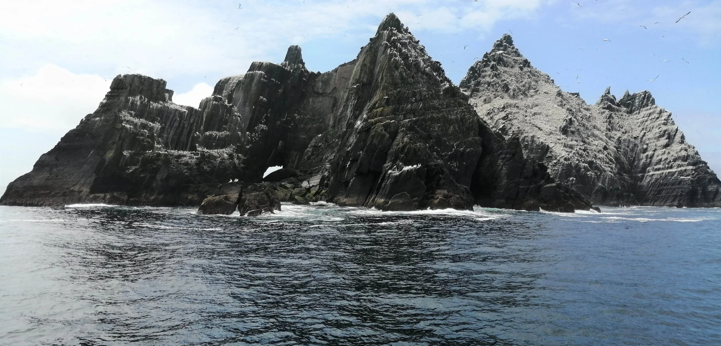
Skelligs
The world renowned Skellig Islands are undoubtedly among Iveragh’s most iconic landmarks. These precipitous crags lie 12km off Bolus Head, making them the westernmost point of the Peninsula. Skellig Michael and the nearby Little Skellig are composed of the same Old Red Sandstone Formation which covers much of the Iveragh Peninsula. The towering pyramid of Skellig Michael also contains a smaller deposit of volcanic ash, known as tuff.
Skellig Michael is famed for its 6th century monastery and hermitage and status as a UNESCO World Heritage Site. The most striking aspect of the structure of Skellig Michael is the twin peaks, separated by the low-lying U-shaped valley known as Christ’s Saddle. The presence of this valley is again controlled by a geologic fault that runs north-south across the island (Bourke et al., 2011). This fault weakened the nearby rocks, making them more susceptible to erosion.
Little Skellig is the smaller but equally impressive counterpart to Skellig Michael and is home to an important bird population. Its jagged rock pinnacles host a massive colony of some 30,000 pairs of Gannets (Gainéad), as well as many instantly recognisable Puffins (Puifín). Distinctly turquoise staining from a mineral called malachite, and specks of copper ore were recorded on the south face of Little Skellig in the old geological maps of 1861.
These dramatic pinnacles can be spotted on the horizon at numerous locations across the peninsula, particularly along the western coast between Ballinskelligs and Valentia. During the summer season, boat tours head out daily from Valentia, Ballinskelligs, Portmagee, and Derrynane. A list of some of the boat providers can be found here.
-

Deenish and Scariff
Located southwest of Hogs Head, Deenish and Scariff Islands make for a majestic view. The west coast of Scariff, as the Irish name ‘Scaribh’ meaning ‘rough place’ suggests, is particularly storm shredded. Thousands of years of wave battering have cumulated in the formation of a dramatic coast of sea stacks, caves, and cliffs and has exposed impressive geologic folds.
Scariff contains the ruins of a monastic settlement and a cottage but has been long abandoned. The island has a surprisingly gruesome history and is linked with the beheading of a monk by Cromwellian Soldiers. Local tradition states that the Red Monk was captured while saying mass on Scariff Island on the 23rd of June 1653. Every year a mass is held in the Red Monks honour, with boats going out to Scariff.
The lower relief Deenish Island contains evidence of ice passing over the island during the last glacial period in the form of glacially smoothed and polished rock surfaces. This once inhabited island is now deserted and has been left to the wilderness.
Deenish and Scariff Island are a designated Special Conservation Area and are best viewed from the Lamb’s Head, Derrynane, and Coomakista.
-

Bull, Cow and Calf
Located to the west of the lengthy Dursey Island on the Beara Peninsula, several Iveragh boat tour
providers including Skellig Coast Discovery and Skellig Tours run trips out to the impressive and remote Bull, Cow, and Calf islands. These dramatic islands are composed of the same Old Red Sandstones found on the Iveragh Peninsula, which gives them their green and purplish appearance.
Bull Rock is the most south-westerly point along the Beara Peninsula, towers 89m above sea level, and is perforated by an astonishing arched cavern. This massive tunnel passage is locally referred to as the ‘Gateway to the Underworld’. Steep jagged cliffs line all sides of this imposing island, with the incredible feat of the old Gas Works and Lighthouse clutching to the eastern cliff face.
The Cow Rock lying between the Bull and Dursey Head, is set apart by its impactful sea arch which gives the rock a distinct likeness to an elephant with its trunk resting in the water.
The Calf Island was the location of the original lighthouse, built in 1866 and composed of cast iron. On the 27th of November 1881, the lighthouse was destroyed as the tower snapped during an extreme storm, leaving behind only a stump of the former lighthouse. The lighthouse keepers survived but were stranded on the island for two weeks while they awaited rescue. The Bull Rock Lighthouse was built in 1889 to replace this structure.
Glimpses of this cluster of islands can be seen on clear days along the southwest coast of Iveragh.
References
Bourke, E., Hayden, A. R., & Lynch, A. (2011). Skellig Michael, Co. Kerry : the monastery and south peak : archaeological stratigraphic report : excavations 1986-2010. Dublin: Dept. of Arts, Heritage and the Gaeltacht.
Mitchell, G. F. (1992). Notes on a Raised Beach between Two Diamicts, Beginish Island, Valencia Harbour, County Kerry. Irish Journal of Earth Sciences, 11(2), 151-163.