
Reading the Rocks - An Introduction to Geology
The dramatic landscapes of the Iveragh Peninsula is shaped by the underlying geology. South Kerry is widely celebrated and appreciated for its rugged natural beauty, yet it is rare that we stop and think about the incredible story behind these rocks. By introducing some key geological principles we hope you can start unravelling the stories of the rocks.
Modern geological thinking emerged in the late 18th Century when a Scottish geologist named James Hutton proposed two hypotheses that profoundly changed our understanding of Earth. Inspired by the observation that mountains are being actively eroded with the eroded material transported and deposited elsewhere, Hutton concluded that the Earth’s geology must be constantly forming. He believed that the wearing down of land surfaces must be countered by the formation of new land through mountain building and volcanism. Before this discovery, it was widely believed that the Earth was around 6,000 years old. However, Hutton recognised that the recycling of rock material occurred very slowly and that a far longer timescale was needed to explain these processes. This led Hutton to introduce two key aspects of geology: deep geological time and the rock cycle [1]. Evidence of the rock cycle is clearly visible on the Iveragh Peninsula. Here the rocks are predominantly sedimentary. The sand grains, mud, and pebbles that formed these rocks are themselves remnants of a huge mountain belt, which was eroded and weathered down to tiny fragments.
Another key principle for understanding our surrounding geology is Uniformitarianism. This concept gained popularity under the Scottish geologist Charles Lyell [2]. This principle is often expressed as ‘The present is key to the past’. This means that the geological processes occurring in the world today such as volcanic eruptions, mountain building, erosion, and the transport of sediment, are the same processes that have always occurred throughout geological time. This principle is particularly useful for determining past environments. For instance, at the tetrapod trackway on Valentia Island, a section of rippled rock is found. Drawing from modern locations where similar ripples are found, we can conclude that the sediment that created that rock began in a desert, beach, or river environment where sediments are rippled by wind or flowing water.

Key geological principles that describe the relationship between rock units.

Ripple marks such as these near Ballinskelligs tell us a lot about the environment before these rocks were formed.
Other useful ideas which emerged around this time include superposition and original horizontality. Together these indicate that rocks tend to be deposited in horizontal or near horizontal layers and that when we look at several layers of rock, the younger rock generally overlies the older rocks. Extending from these, the principle of cross-cutting relationships states that deformation features such as folds, faults, and volcanic intrusions that cut across rocks are younger than the host rocks. Similarly, the principle of inclusions states that when one rock formation contains pieces of another rock, the included rock is older than the host rock.
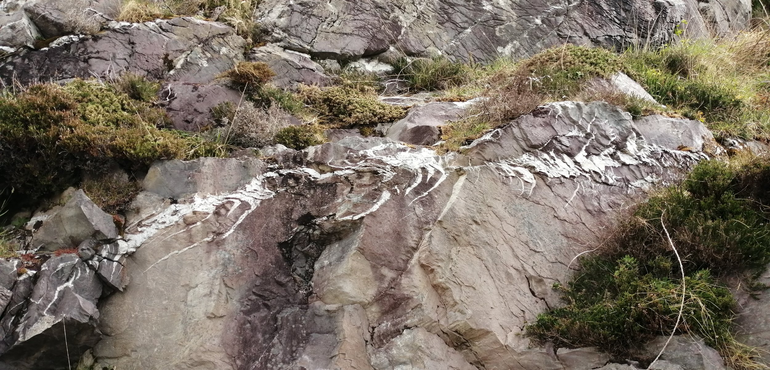
Features such as this quartz vein are younger than the surrounding rocks.
While technology has advanced greatly since the 18th Century, these fundamental geological principles have remained firmly in place. Although these principles may seem simple now, much of their usefulness lies in how accessible they are. They provide tools that can be used by anybody to piece together the story of the rocks and are particularly useful for developing a sense of the passing of time as each succession of rock layers likely represents millions of years.
However, by examining the rock type the story of the rocks really comes to life as the environments and climates of the past are revealed.
Rock Classification
Rocks are classified into three groups according to how and where they form. These are igneous, sedimentary, and metamorphic.
Igneous Rocks
Igneous rocks are formed by the cooling and solidification of hot molten rocks. There are two types of igneous rock. Magma that cools and solidifies below the Earth’s surface forms intrusive rocks such as granite. Alternatively, magma that erupts to the Earth’s surface as lava and solidifies forms extrusive igneous rocks such as basalt.
On the Iveragh Peninsula igneous rocks make up a small proportion of the exposed rocks but are important as they contain minerals that have been used to date the rocks of the area. These igneous rocks are largely centred around Valentia Island and Beginish Island, where an intrusive rock called dolerite is found. Intrusions of dolerite are also found at St. Finian’s Bay and from Whitestrand to Doulous Head. Another type of igneous rock called tuff is also found in small quantities on the Iveragh Peninsula at Keel Point and Enagh Point. This tuff formed as ash from a large volcanic eruption fell to the ground and was deposited and welded together. Igneous rocks provide evidence of past tectonic activity and suggest a more violent time in Iveragh’s history where nearby volcanic eruptions were not uncommon.
Sedimentary rocks
Sedimentary rocks form from the building up of layers of sediment. Over time as these layers accumulate, they are subjected to huge pressure and are cemented together and lithified to form solid rock. Sedimentary rocks can be clastic, meaning they are made from the fragments of other rocks, for example, sandstone; organic meaning they form through the accumulation of dead plants and animals, for example, coal; or chemical meaning they form through the precipitation of minerals, like limestone.
Sedimentary rocks cover almost all the Iveragh Peninsula and are most commonly siltstone, sandstone, and conglomerate, which belong to a group of rocks known as The Old Red Sandstone Formation. Sedimentary rocks are important as they tell us the story of past life, climates, and major events that occurred throughout Earth’s history. The presence of sandstone and siltstone on the Iveragh Peninsula have allowed geologists to determine that around 385 million years ago the area was much hotter than today and was covered by a vast desert and floodplain. These rocks also preserve fossilised evidence of past life, most famously the tetrapod footprints at Valentia Island.
Metamorphic Rocks
Metamorphic rocks are formed from the alteration of existing rocks under immense heat and pressure. These conditions are found deep within the Earth or during mountain building events where tectonic plates collide.
The quarry at Valentia Island contains a metamorphic rock called slate. Slate is formed from metamorphosed mudstone. The presence of these metamorphic rocks provides evidence of a mountain building event in the past. This mountain building event occurred around 300 million years ago when two continental plates collided causing the Earth’s crust to buckle and fold. The mountains and hills you can see around the Iveragh Peninsula today are a product of this event.
Geological Time
One of the most fascinating things about geology is the immensity of the timescales involved. According to the most recent estimates, Earth formed around 4.5 billion years ago. Geologists have divided the massive expanse of time since Earth’s formation into a structured timescale. This timescale acts as a reference and a means of communication for comparing rocks and fossils throughout the world. Two timescales are used when describing geological time: the relative timescale and the absolute timescale.
The Relative Timescale
The relative timescale was constructed by early geologists who had no means of assigning precise ages to rock units but understood that rocks formed over very long periods of time. Using principles such as superposition and original horizontality, these geologists were able to construct a relative time scale based on the chronology of the rocks. This chronology was formed on the assumption that the oldest rocks are located at the base of rock units with the sequence getting progressively younger moving upwards through the layers. As there are no single rock units that spread across geological history without interruption, the relative timescale has been pieced together from rocks of different ages across the world.
While certain features such as evidence of past oceans, large scale volcanic and ash deposits, and widespread deserts are useful for distinguishing between different time periods in particular areas and tracking the passing of time, the presence of fossils was key for constructing and dividing the geological timescale. Evolution has produced a unique fossil record with distinct assemblages of fossils contained in rock layers according to the period in which they lived. The presence of certain characteristic fossils and assemblages across large geographic areas have been used by geologists to divide geological time into Eras, Periods and Epochs. These subdivisions are used in a similar way to the division of the year into months. However, these periods are not equal in length but are rather based on natural changes in earth’s history as recorded in the rock record, with changes tending to be episodic and occurring in sudden spurts rather than in gradual and predictable patterns.
The boundaries of these periods are often placed where there is an abrupt change in the fossil record. Extinctions as well as the appearances of certain fossils most commonly mark the boundaries between periods. While the basis for constructing periods is often grounded in big changes in species assemblages, for example, the end of the Cretaceous period coincides with the extinction of dinosaurs, it is rarely those big species that are used to constrain time periods. More often than not the appearance or disappearance of small species, sometimes only a few milimetres in size, are used as they are more widespread, abundant, and diverse.
Absolute Timescale
The relative timescale is useful as it allows Earth’s overall history to be told by ordering the sequence of events, as well as indicating which species existed together, when different species thrived or became extinct and how they evolved. However, it is limited as it can’t be used to determine the rates of processes and changes or how long each period lasted. In the middle of the 20th Century, the emergence of the modern technique of radiometric dating revolutionised the geological timescale. This discovery enabled geologists to assign accurate ages to the periods of Earth’s history. Unveiling precisely how far back geological time stretched was a mind-boggling discovery. Gradually depth became perceivable in the history of our planet.
The geological timescale has been constructed from hundreds of years of investigation, but it remains a work in progress, with groups actively working to assign more accurate dates to the absolute timescale.
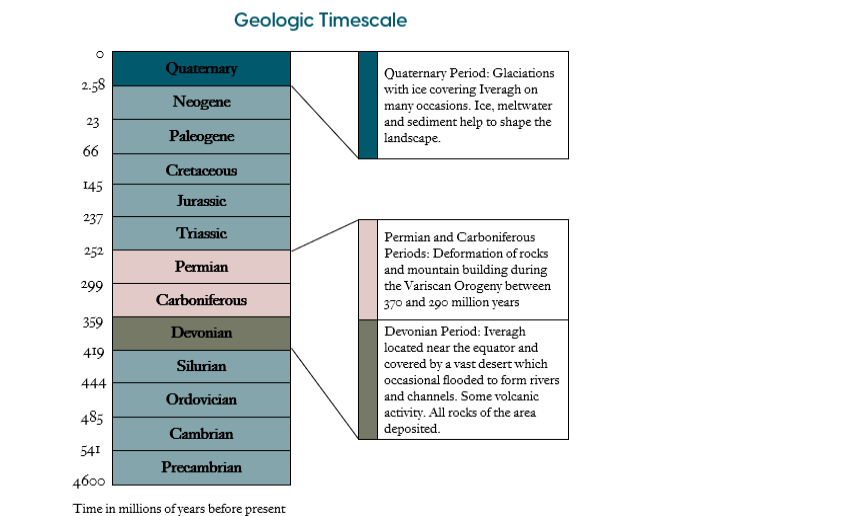
Geological time scale highlighting the key periods and events in Iveragh’s geological history.
Geological Time Perspective
Spanning 4.5 billion years, the concept of deep time is so difficult to grasp that analogies are commonly used to help put it into perspective. One common analogy involves viewing the whole history of the Earth as a single 24-hour period. This example begins with the formation of earth 4.5 billion years ago occurring at 12 midnight. Single-celled life appears at around 4:00 a.m. or 3.5 billion years ago and these primitive lifeforms are not joined by multicellular life until 5:30 p.m. or 600 million years ago. The first aquatic animals appear just after 8:00 pm or around 558 million years ago. All the activity up until this point takes place within the first geological period, the Precambrian. Following this marine life thrives. Plants colonise the land in the Silurian at around 9:40 pm or between 480 to 460 million years ago, with
land animals following just after 10:00 pm. Dinosaurs arrive in the Triassic at around 10:40 pm, approximately 230 million years ago and dominate for an hour until the end of the Cretaceous period, where at 11:40 pm they go extinct. In the final 20 minutes and the most recent 66 million years of Earth’s history, most modern mammals evolve. Modern humans don’t arrive until around 2 seconds before midnight.
Applying this model to Iveragh allows a greater appreciation of the area's geological history to be developed. All of the rock in Iveragh formed during the Devonian Period which lasted from 419 to 359 years, meaning the whole of the Devonian would have infolded between around 9:49 pm to 10:07 pm. During this time the world’s first forests were forming and life including the Valentia Tetrapod was beginning to move onto land. The mountain building event that formed Iveragh’s peak would have been concentrated around 10:30 pm or 300 million years ago. The next big event in Iveragh’s history, the Ice Ages of the Pleistocene, which began around 2.6 million years ago places us at about 11:59:11 pm. The first evidence of humans in Kerry dates back to over 6,5000 years ago. That means that the whole human history of Iveragh accounts for the equivalent of a fraction of a second in the history of Earth.
While this distant past often feels inconceivable, it is also readily observable. Anywhere on the Iveragh Peninsula where you see sedimentary rocks exposed you are looking at evidence of the vast Devonian desert and floodplain which covered the area around 385 million years ago!