
Knockeenawaddra & Pound Loops
LOCATION: Portmagee
LENGTH: 7.5km to 8.5km
DIFFICULTY: Moderate
PARKING: Gortreagh, Portmagee
A little bit about the area
Our map does not correspond to exact points or numbered signs along the trail. Instead, this map is seen as a companion for the area, filling you with information on what you might find and where you might find it. It will hopefully add to your enjoyment of this wonderful corner of Iveragh and help build the memories that will stay with you long after you leave.
Two looped walks intersect on the lands outside Portmagee: Knockeenawaddra and the Pound. The Pound Loop is about two hours in length, as it takes a shortcut along the broken line on the map between points 7 and 10. The Knockeenawaddra Loop, on the other hand, takes 3 hours, as it follows the solid line through an area of blanket bog. Depending on weather conditions, the longer loop can be wet and boggy underfoot - so which route you take depends on how well-prepared you are for those conditions. The remainder of the trail passes along tarmac roads or farmland where you may meet cows, sheep, goats and even some ducks crossing the road!
Due to the presence of farm animals, dogs are not permitted on the trail. Hiking boots are highly recommended due to the uneven, and sometimes muddy, nature of these farm sections. As with many of Iveragh's hiking trails, the cooperation of local landowners is what makes these experiences possible. The picturesque waterfront village of Portmagee is close to the start point - ideal for picking up drinks or snacks for the walk. There are public toilets in the village carpark, as well as shops and high stools to relax on during a cool winter's evening.
HOW TO EXPERIENCE THE MAPS:
The map locations can be seen on your mobile device. Clicking on the square icon in the top right hand corner of the respective map to open the map in a web browser or Google maps app. Or you can click on the square in the top left of the map to follow it on this page.
TRAIL GUIDE:
Below the maps is the guide for the map and the selected points.
There is also an alternative Storymap:
Knockeenawaddra & Pound Loops Guide
-

1. Start/Finish Point
The start and end point for both the Knockeenawaddra and Pound Loop walks is 2km east of the village of Portmagee, on the road to Cahersiveen. At this junction on the R565, there is a gravel parking area where you will find signage for the loop walks. Portmagee itself is a warm, picturesque village where there is so much to see and do, including restaurants, pubs, cafés, a gift shop, visitor centre and even a whiskey distillery in one small location. As Portmagee is just across the bridge to Valentia Island, there are so many options to fill your time in such a beautiful corner of the Iveragh Peninsula. So, having worked up an appetite along the trail, why not return to Portmagee for some locally caught seafood.
-

2. Transatlantic Cable
Up to the mid-1800s, it took weeks to send messages across the Atlantic by ship but the establishment of the first Transatlantic telegraph cable reduced this time to mere minutes. In July 1866, the Great Eastern – the largest ship of its time – laid 1,600 miles of cable to change the face of global telecommunications. After four failed attempts to lay cables and a completed cable being destroyed by a power surge, the first successful Transatlantic communications cable was laid between Foilhommerum Bay, Valentia and Heart’s Content, Newfoundland.
The Valentia Telegraph Station employed around 40 staff and their families lived locally in what was a historic time on Iveragh. The station operated for 100 years, closing in 1966, when satellite communications made cable redundant. There is currently a bid to gain UNESCO World Heritage status recognition for the historic Valentia cable sites, including the recently renovated Telegraph Station. More information on the historic sites and cable trail can be found here.
-

3. Maurice O'Neill Memorial Bridge
At a number of points on the trail you will have views of the bridge connecting Valentia Island to the mainland at Portmagee. The Maurice O’Neill Memorial Bridge was built in 1970, after decades of campaigning by local groups, and named in honour of a local republican man who was executed in 1942. The bridge had two opening ceremonies in 1971 – one was a hurried affair on New Year’s Day, so a second more official opening was arranged for Easter. Originally operating as a swing bridge, a mechanical fault has resulted in the bridge no longer opening to allow taller vessels through. Fishing, sightseeing and rescue boats can navigate safely under the bridge, as they follow the Portmagee Channel, and this is also a great place to look out for marine life such as seals and dolphins.

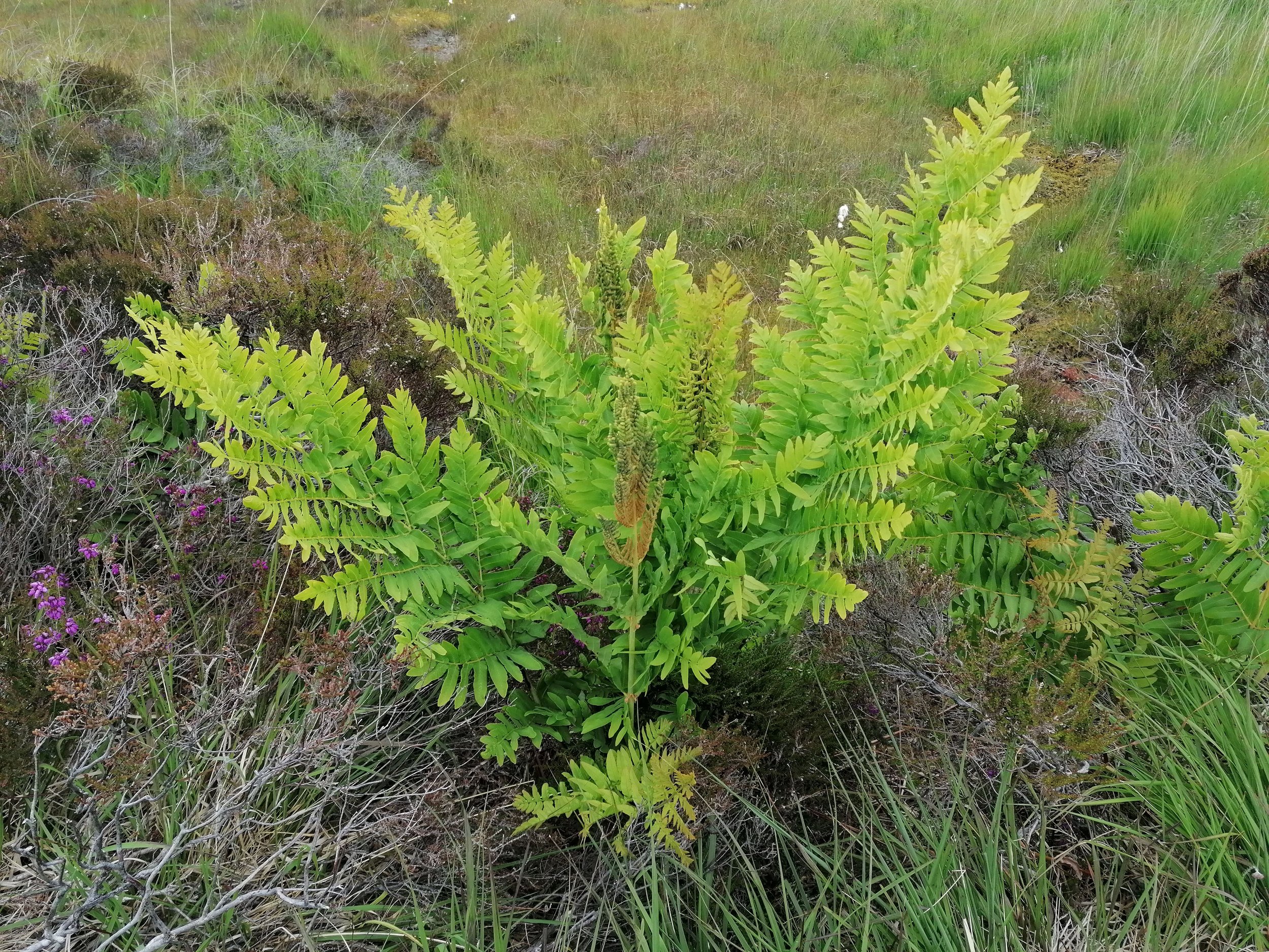
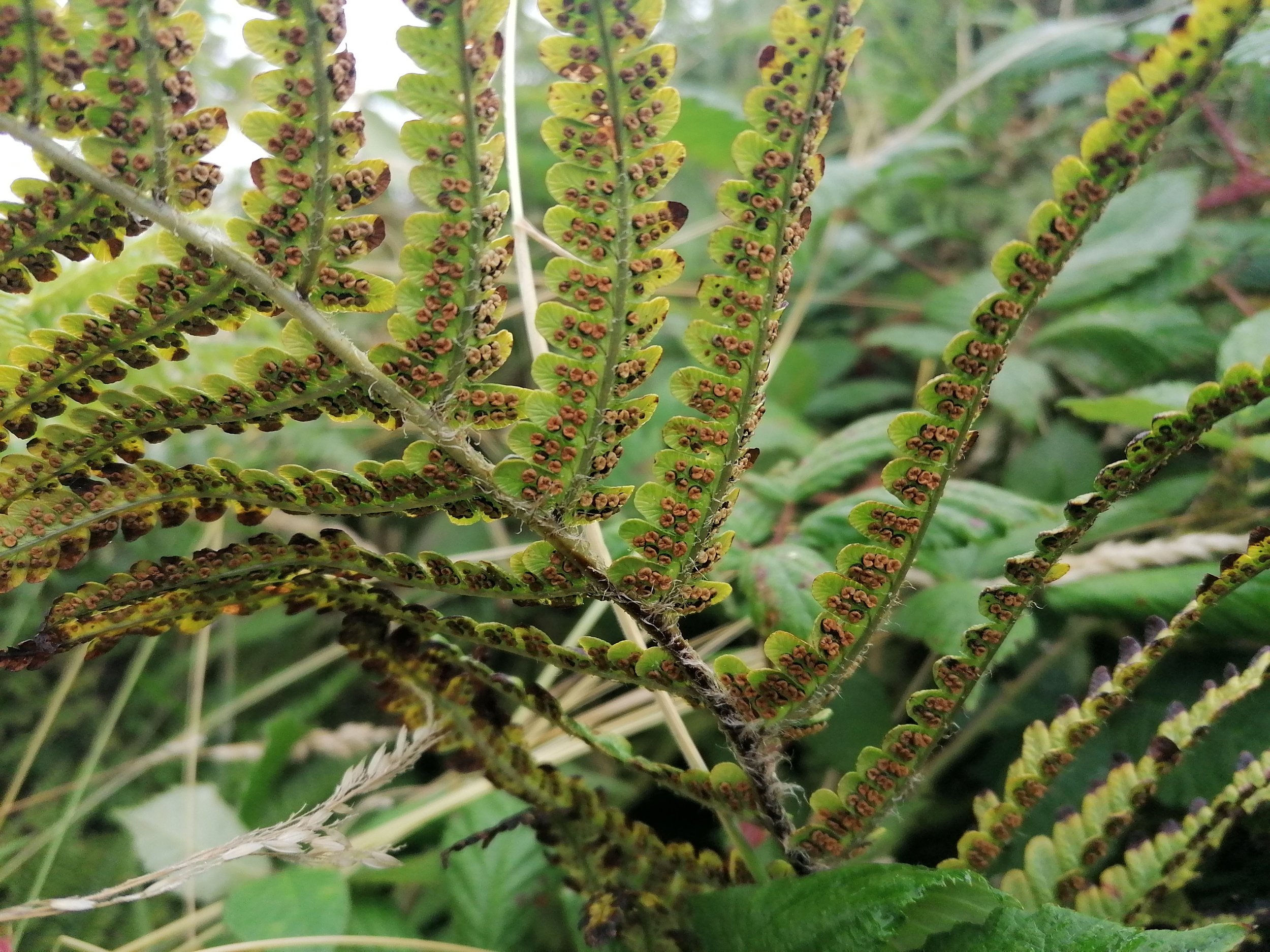
4. Ferns
Many of the hedgerows along the trail are brimming with wildflowers come spring. The other group of plants that appear in abundance on the route are our Ferns (Raithneach). Some are small and delicate, clinging to stone walls and emerging from gaps, like the beautifully named ‘Maidenhair Fern’ (Lus na Seilge). Others have notable features which may help you distinguish between them such as the dark stem of the ‘Hard Fern’ (Raithneach Chrua) or the solid single leaf of the ‘Hart’s Tongue’ (Creamh na Muice Fia). Hart is an old name for a deer and the shape of this particular fern resembles that of a tongue.
In Spring, you will see many ferns emerging – their fronds uncurling from a spiralled coil. In late summer, you will notice the reverse of many fern fronds turning an orange colour. On closer inspection, a collection of small mounds can be seen. These are known as ‘sori’ and are the reproductive spores of our ferny friends. The Royal Fern (Raithneach Ríuíl) can be found in abundance along this trail and rather than forming spores on their fronds, they project a central fertile frond of a rich brown colour. One of the most well-known ferns is Bracken (Raithneach Mhór). It is ubiquitous in our woods and uplands, blanketing the latter in a golden palate come autumn.

-
5. Star Wars
Portmagee has always been a popular spot but in 2014 the village hit global headlines. The cast and crew of Star Wars arrived in the area to film scenes for ‘The Force Awakens’ in the suitably otherworldly setting of Skellig Michael. Hollywood stars such as Daisy Ridley and Mark Hamill (none other than Luke Skywalker himself) rubbed shoulders with the locals and returned to the area again to film for ‘The Last Jedi’. While many may have watched the films and assumed it was some kind of blue-screen creation of a cinema writer’s imagination, others recognised the backdrop as Skellig Michael, the UNESCO World Heritage site just 12 kilometres off the Iveragh coast.
Since then, many fans of the franchise have flocked to Portmagee (or Porgmagee as it is briefly renamed on May the 4th each year), in honour of the puffin-inspired porg creatures of Star Wars. The boat trips to the islands are more popular than ever following their stardom, however, superb views of the Skelligs can be experienced all year round (weather permitting!) from various points along Iveragh’s beautiful coastal routes. Boat trips regularly go out from Portmagee but must be booked well in advance.
-
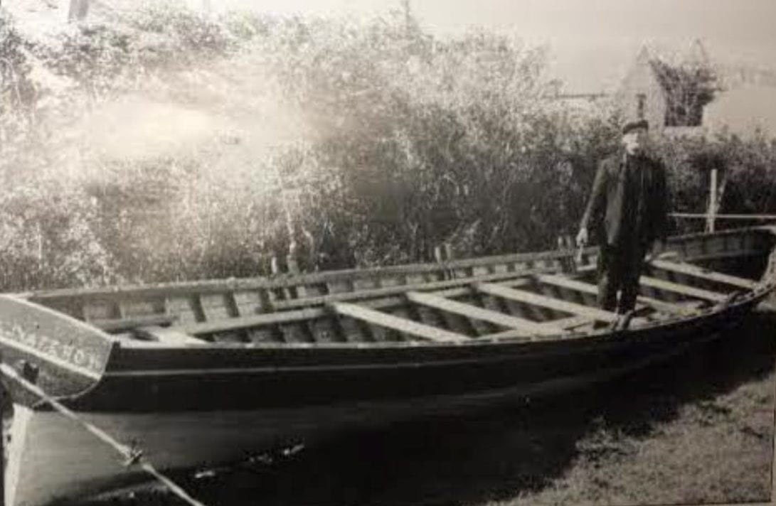
6. Seine Boats
Seine boats are timber-built vessels synonymous with Iveragh’s coast, both in terms of fishing and racing. A seine holds 12 oarsmen and a coxswain who was responsible for steering and navigation. Annual rowing regattas draw huge crowds and fierce rivalry between regions, with the seine race the highlight for many.
Between 1920 and 1950, nine seine boats operated along the Iveragh coastline fishing for mackerel and herring – five of them were based in Portmagee. Up to 300 people were employed through this industry, from fishing to curing and boat repairs to coopering. Seine boats worked with a ‘follower’ boat and dropped their seine nets into the water at night. Weighed down by stones, the net would fall through the water and other stones were used to scare fish into the net. Great physical effort was needed to close the net around the shoal of fish before the catch was hauled onboard. You can learn more about the history of the seine boats and boat building on the Skellig Coast website here, or read an Irish Times article on seines here.
-

7. What's in a name?
Breaking down a place name and translating it in sections is often the best approach to understanding the meaning of a name. Knock comes from ‘cnoc’ meaning a hill. Knockeen will have come from ‘cnocín’ – little hill. The ‘w’ in 'na waddra' might throw you off, but if we said it was from ‘an mhadra’ – the dog – you may see where the anglicised name came from. Put it all together and you have ‘little hill of the dog’.
Portmagee may be a bit more obvious, but who is the ‘Magee’ the port was named after? In the 18th century, Captain Theobald Magee was the chief smuggler of all things contraband around Iveragh. The small coastal settlement of mostly fishing families began to grow around this time and soon adopted the name of Port Magee.
On first glance, you might assume that Valentia Island was named after the Spanish port of Valencia, perhaps by visiting sailors. Valentia Island, however, is known as “Oileán Dairbhre” in Irish which translates to “the Island of the Oaks”, as it is said that the island used to be covered in oak trees. The English “Valentia” derives from the Irish words “Béal Inse”, meaning ‘the mouth or the estuary of the island’.
-
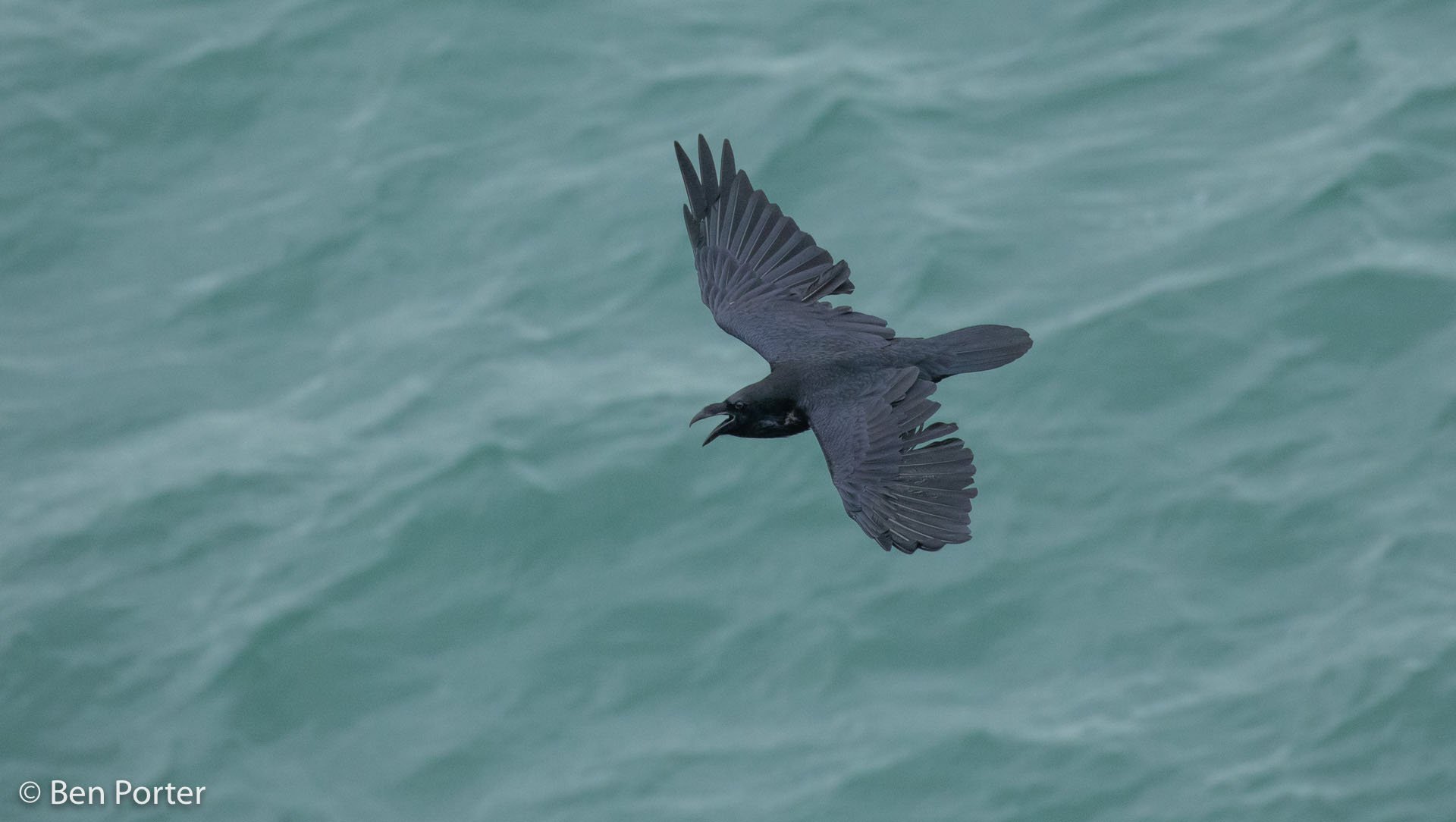
8. Ravens
The largest members of the crow family, Ravens (Fiach Dubh) can be seen soaring in the skies over the trail. With a wingspan of around 4 feet and a deep, croaking ‘kaaw’ call, it is no surprise that these birds are so heavily linked into myths and folklore. The Norse god Odin kept two ravens close to hand and it is said that they travelled the world to gather secrets on his behalf. In Celtic mythology, ravens were often other beings in disguise – such as the goddess Morrígan, famous for her connections with Cú Chulainn.
Ravens can be seen on Iveragh’s uplands and around coastal areas – cliffs in particular. Their spectacular acrobatics are a highlight of late winter/early spring, as aerial combat is used to hold territories in prime nesting sites. A pair may lock feet and tumble through the air while grasping each other in a heart stopping tussle. On other occasions they perform ‘flight inversions’ – flying in a straight line before rolling upside down to display their prowess to both rivals and potential mates. Read more about ravens in our article, or about our other crows in our corvid series here.
-

9. Peatlands
The eastern part of the Knockeenawaddra loop takes you through peatlands which can be wet underfoot. Waterproof boots are recommended, and care should be taken to avoid any hidden obstacles.
A wealth of invertebrate life can be found around our bogs – from Dragonflies (Snáthaid Mhór) to Moths (Leamhan) and Butterflies (Féileacán) of all shapes and sizes. They are on the dinner menu for another group of specialist bog predators. Not of the feathered or furry kind but of the carnivorous plant kind. Yes, you read that right! Due to poor nutrients in the soil, some plants such as the Sundew (Drúchtín Móna) and the Butterwort (Bodán Meascáin) have special adaptation to allow them to capture insects for food. Sticky and sweet-smelling secretions lure in their prey which become entrapped and are slowly digested.
Formed over thousands of years from the build-up of slowly decaying vegetation, bogs tend to form in areas of high rainfall and low evaporation. They are vital carbon stores, so their protection and restoration are crucial in our fight against climate change. They are also home to some of Ireland’s most iconic wildlife such as the Curlew (Crotach) and the Common Lizard (Laghairt Choiteann). The Irish Peatland Council has some wonderful activities and information on their website about the flora and fauna of peatlands, including how bogs are formed.
-

10. Butterflies
The hedgerows that line this route provide wonderful opportunities to watch some Butterflies (Féileacán) flutter by. In spring, the Orange-tip Butterfly (Barr Buí) is one of the first you will see. The males have a distinctive orange patch on their otherwise white wings which is absent in the females. The Small Tortoiseshell (Ruán Beag) may be a familiar sight around some of our homes, choosing a dark corner to hibernate over winter. Like many of our butterflies, the underside of their wings is a dull colour – aiding camouflage – but opened wings reveal a different picture. Tiny structures across the surface display rich oranges, browns, and marine blue dots. The wings of other species, such as the Peacock Butterfly (Péacóg), are adorned with patterns that resemble large eyes. These eye spots aim to fool predators into thinking they have been seen, or are dealing with something much larger than the butterfly really is.
Over 30 species can be found in Ireland and Irish Butterflies is a great website to help you identify them. The National Biodiversity Data Centre also have beautiful swatches (that fit neatly into your pocket) on Butterflies, Ladybirds (Bóín Dé) and Dragonflies (Snáthaid mhór) to name but a few. Keep an eye out for Caterpillars (Bolb) and cocoons too, these are other forms of butterflies and Moths (Leamhan) as they metamorphose their way through their life cycle.
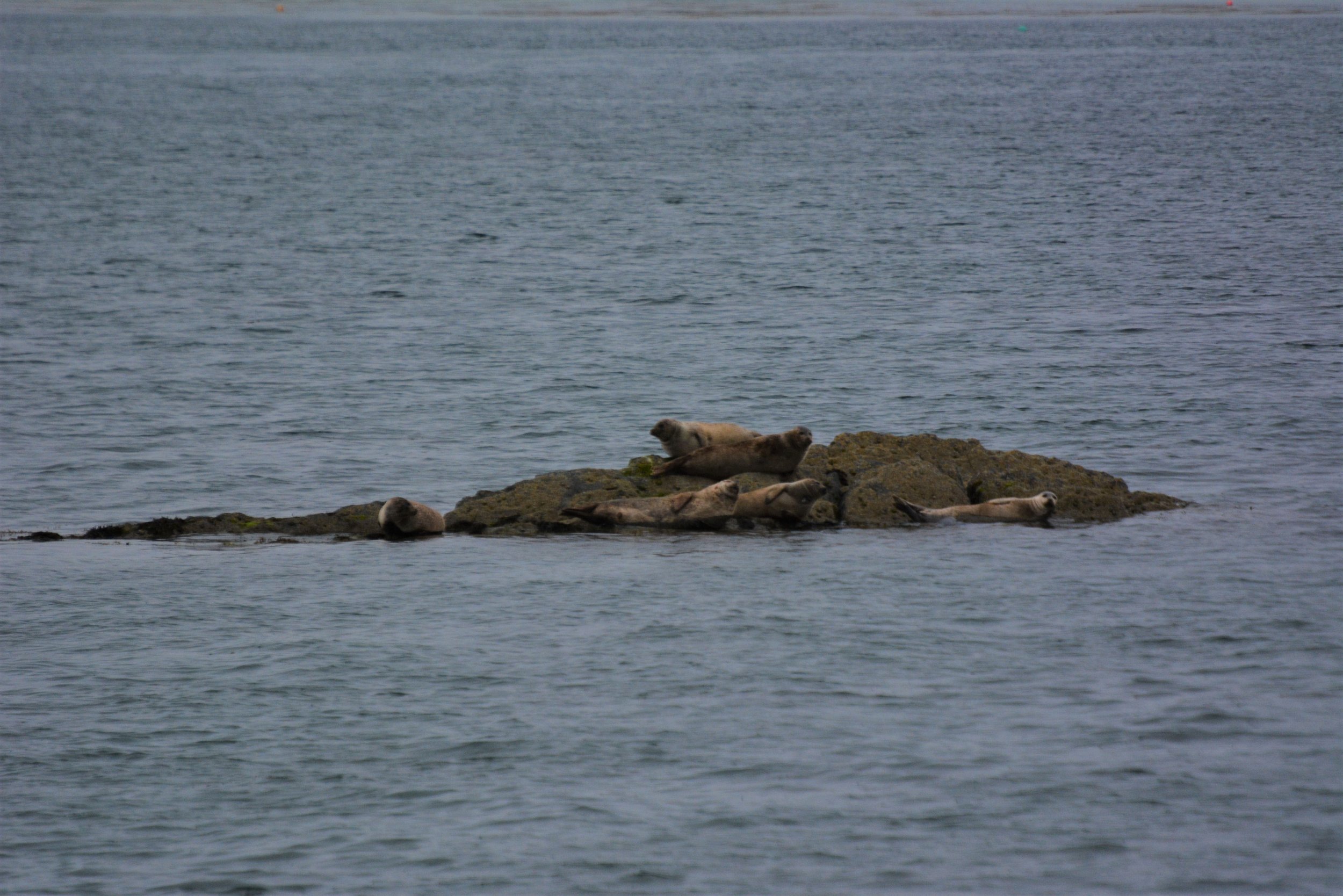
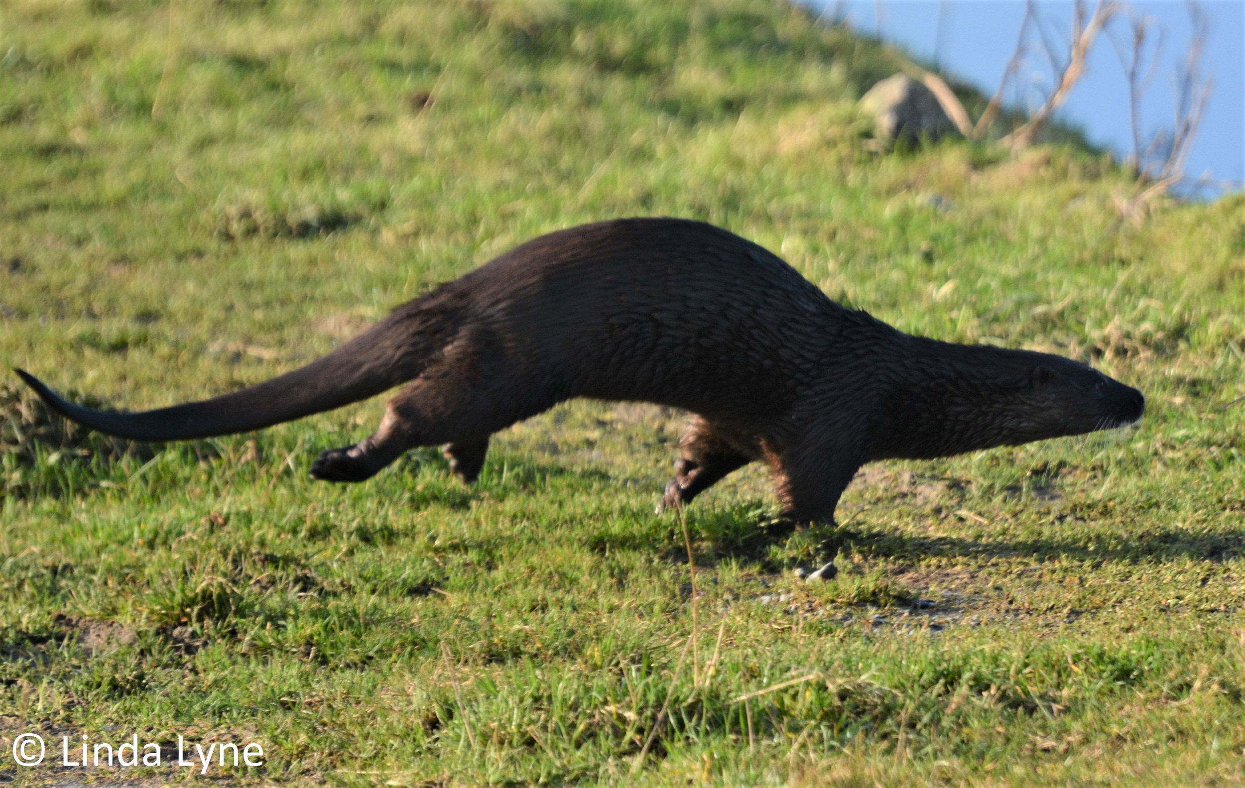
11. Portmagee Channel – Wildlife
You will travel the road adjacent to the Portmagee Channel to arrive at this walk and you will also have views from higher points on the trail. This ‘Special Area of Conservation’ is a great place to watch for some of our marine wildlife. If you are lucky, you may experience the magic of an encounter with an Otter (Madra Uisce) combing the shoreline for Crabs (Portán) hidden in the seaweed, or in rockpools exposed at low tide. Larger rocks just offshore are popular spots for Seals (Rón) to haul out – their banana shaped curves are often the only giveaway as their fur blends so well with their surroundings.
The movement of tidal flows through the channel provides nutrients for a host of other species. Some are largely sedentary, such as Anemones (Anamóine) or many Shellfish (Sliogiasc) - waiting for food to pass them by and get caught in their outstretched filter-feeding structures. Others live life on the move in a big fish eats the little fish race for survival. Much of this wildlife goes hidden beneath the waves, but on some occasions it takes centre stage as a tantalising glimpse of a shape on the surface catches your eye. Perhaps it’s a splash or the sound of a sharp exhale that alerts you first – and then the sun glistens on the back of a Dolphin (Deilf) as it breaks the surface…and then another….and maybe another! It’s always worth your while scanning the channel when you get a view.
-
12. Portmagee Channel – Maude Delap
Maude Jane Delap was born in Donegal, but her family moved to Valentia Island in 1876 when she was just 8 years old. Here, on Valentia Island is where she lived until her death in 1953, at the age of 86. In a time where it was unusual for women to contribute to scientific research, Maude Delap became a self-taught marine biologist despite not having received a formal education. She made valuable insights into the life cycles of jellyfish and amassed an impressive collection of specimens, many of which are still kept in the Natural History Museum in Dublin.
Her most notable discovery was that of a rare Sea Anemone (a relative of jellyfish) that can only be found in the shallow waters of the Portmagee Channel. It was named in her honour - Edwardsia delapiae. From her home in Reenellen, Maude, accompanied by her sister Constance, would spend her life searching the seas around Valentia Island, regularly collecting samples and writing scientific articles in her own name – another rarity for the women of her generation.
Edwardsia delapiae is described as having a long worm-like body hidden in the sand, with its 16 tentacles spread in a 40mm ring above the sand. With these tentacles, the anemone catches passing prey items, which are passed to its mouth in the centre of the tentacle ring.
-

13. Portmagee Channel – Geology
On some of the higher points of the trail you will gain beautiful views of the long finger-shaped hollow that runs along the Portmagee Channel. In part, it owes its form to the action of the glaciers that slowly swept across the region during the Quaternary Period. Throughout the Quaternary, starting from about 2.6 million years ago, these ice sheets continually advanced and retreated across the landscape. The most recent glacial maximum (period of maximum ice extent) occurred around 25,000 to 20,000 years ago.
During this maximum, huge ice sheets, up to 600m thick in places, ravaged Iveragh’s landscape, sculpting and carving the bedrock to form valleys and troughs. As glaciers flowed down from the mountains surrounding the Fertha Valley, sharp boulders and rocks embedded in the base of the glaciers scraped and eroded the underlying bedrock; through this action trough between Valentia Island and Portmagee was formed.
As these great ice sheets began to melt, about 14,500 years ago, vast quantities of meltwater gushed into the seas and caused a rapid rise in sea level. It was during this sea-level rise that water breached and flooded the glacially excavated trough, and the Portmagee Channel was formed.
-

14. Spiders
Love them or hate them, Spiders (Domhán Alla) are part of the complex food chains that surround us in nature. We have over 1,000 species of arachnid in Ireland, 390 of which are native species. You may never encounter many of these species, as they are hidden in the undergrowth, high up in trees, or are too tiny to easily lay eyes on. A frosty autumnal morning reveals their spectacular architectural feats in all their glory. Complex structures drape from twig to twig, or gate to fencepost – something they seem to create at incredible speed and with mathematical accuracy. Others form webbed funnel shaped dwellings, all the more difficult for their prey to escape from. With patience and stealth, they feel for the slightest clue - such as vibrations on their silken creations - before launching at their hapless victim.
But the predator becomes prey on many occasions as spiders are on the menu for many. Birds (Éan), Bats (Ialtóg), Lizards (Laghairt), Frogs (Frog), Fish (Iasc) and even other spiders – everybody wants a spider snack! Without spiders controlling certain species and without spiders providing food for many other species, the imbalance would be disastrous. Like much of nature, everything has its place. Our eight-legged friends have earned their place too so next time you see one you will remember they are important links in a greater food web.