
Portmagee to Waterville Geosites
LOCATION: West Iveragh
The Geologic Story
The region from Portmagee to Waterville is a landscape of contrasts, where ultra-cut out cliffs and rugged rocks, give way to long stretches of golden sands and sheltered glistening coves. Over the past 390 million years the area has travelled across the equator on the slow conveyor belt of plate tectonics, and at various times has been plunged into hot and dry desert environments, submerged beneath tropical seas, caught up in a continental collision and overridden by vast ice sheets. Together these events have created the unique and spectacular landscape of Iveragh today.
The area is dominated by the Old Red Sandstone Formation, a group of rocks deposited between 393 and 360 million years ago, during the Devonian Period. The three regional formations of the Iveragh Old Red Sandstone, the Valentia Slate Formation, St. Finian’s Sandstone Formation, and Ballinskelligs Sandstone Formation are all found between Portmagee and Waterville.
HOW TO EXPERIENCE THE MAPS:
The map locations can be seen on your mobile device. Clicking on the square icon in the top right hand corner of the respective map to open the map in a web browser or Google maps app. Or you can click on the square in the top left of the map to view it on this page.
TRAIL GUIDE:
Below the maps is the guide for the map and the selected points.
There is also an alternative Storymap:
Portmagee to Waterville Geosites
-

01. Kerry Cliffs
The Kerry Cliffs are savage and wild, offering not only a dramatic setting and spectacular views of the Skellig Islands, Puffin Island, and the Atlantic Ocean, but also exposing some fascinating geology. These cliffs stretch for over 5km and rise sheer over 300m above the Atlantic. Walking along the path at the Kerry Cliffs is a walk on the edge of a landscape that was sculpted by millions of years of geological activity, weathering, and erosion.
The rocks of the cliffs formed more than 385 million years ago when layers of sediment gradually built up over millions of years. Each of these layers acts as a physical reminder of how this rock was laid down and can be linked to a specific depositional event, such as a flash flood or the existence of a river channel. The layers vary in thickness and accumulated at a rate of about one-tenth of a millimetre per year, shedding some light on the immense time taken to create these formidable cliffs. Preserved within these layers are millions of years of Earth’s history during a period of considerable change. Throughout this period, Earth saw an increase in plant and animal diversity on land, the evolution of many fish, as well as the appearance of the first amphibians.
This cliff section is remarkably rugged with a highly serrated appearance and many promontories extending out into the ocean. This rugged form developed through the constant assault from the elements over thousands of years. The Atlantic incessantly froths and crashes against the base of the cliff, providing an opportunity to see nature at its most powerful. Scanning the cliffs for evidence of coastal erosion, you will see sea caves etched into the base of the cliff and places where large areas of the cliff face have collapsed, leaving large slabs of rock slumping into the sea. These cliffs are dynamic, and erosion may expose new features of geological interest over time.
At one section of the cliffs, you may notice a clear disruption in the layers, where one section of the rock layer seems to have buckled. This formed when a fault developed within the layers during the mountain building, splitting the rock and allowing this section to be pushed above the others.
Wildlife is also a draw and many bird species including puffins, gannets, and razorbill frequent the cliffs, swirling overhead and plunging into the sea below.
-

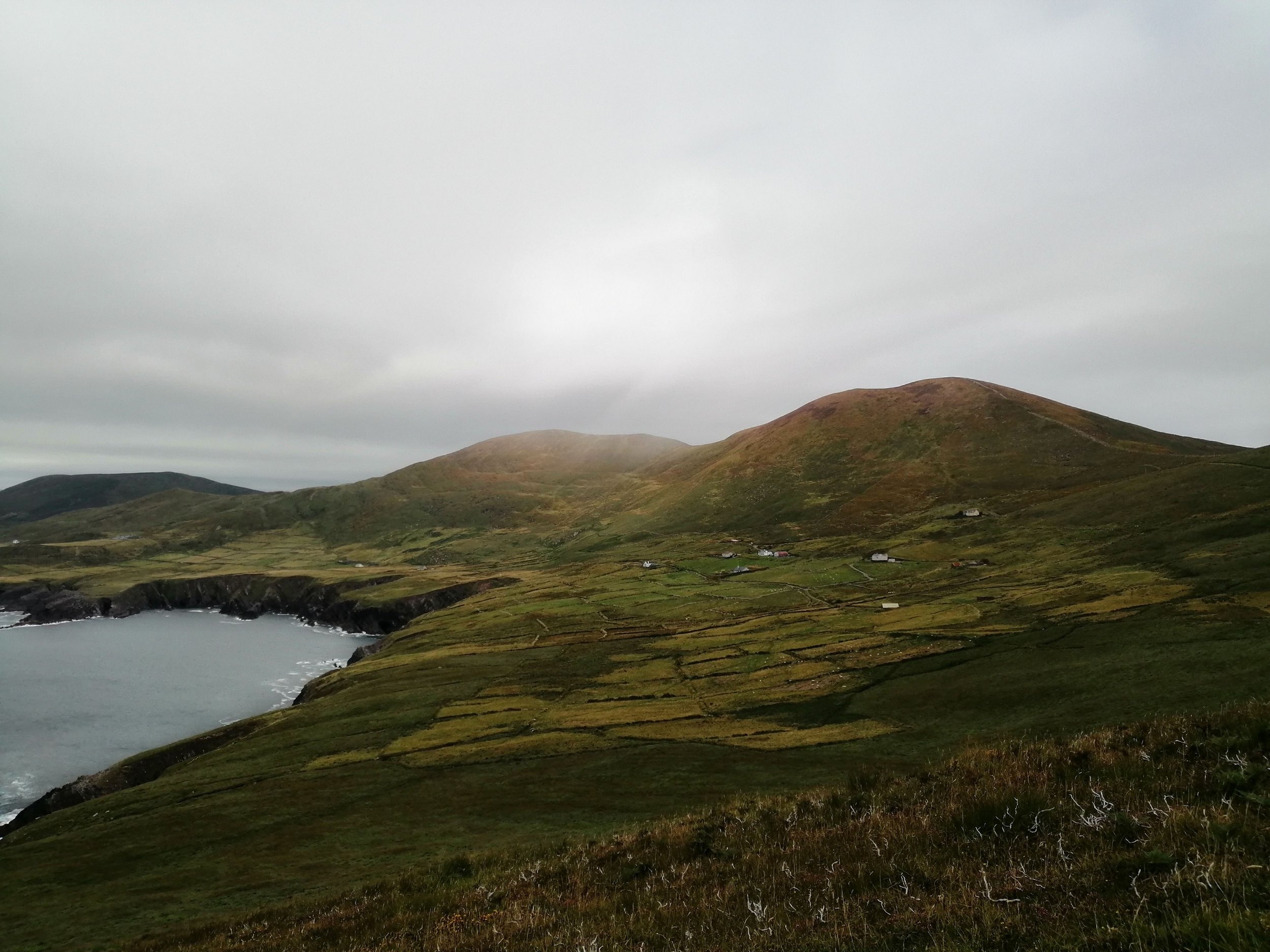
02. Com an Easpaig
Aside from being an outstanding picture point, Com an Easpaig allows you to review at a glance many of the geologic processes of Iveragh’s past and present. These processes involve the building of mountains and valleys, the formation of geologic faults, and the subsequent erosion and destruction of these features.
From Com an Easpaig we see the impact that the Variscan mountain building event had on the landscape. The mountain ridge that extends eastwards from Com an Easpaig lies on the major Portmagee anticline which has its corresponding syncline in the Ferta valley. Anticlines are n-shaped folds that usually form mountain peaks, while synclines are u-shaped folds that usually form valleys. These folds were created by compression during continental a collision.
To the north, we see the impact that faulting had on the landscape. Faults are large fractures and fissures that allow blocks of rock to move relative to each other. The straight course of the River Ferta as it flows past Cahersiveen and into the Portmagee Channel, moves along the line of a major geologic fault, known as the Coomnacronia Fault. This fault is believed to have been an important northern margin of the Munster Basin (Parker, 2017). The presence of this fault created a zone of weakness in the rock and allowed for the formation of an eroded rock hollow that acted as a natural drainage route for the river.
Geology can also be seen in action in the present day. Evidence of erosion can be clearly seen looking back at the Kerry Cliffs, which are actively being eroded by the power of the Atlantic Ocean. The erosion of these cliffs and the wearing down of the mountains by river channels and streams will ultimately be followed by rebuilding and new rock formation, as the geologic cycle continues.
-

03. St. Finian’s Bay
St. Finian’s Bay is an area of geologic significance for several reasons. Firstly, although the area is predominantly underlain by the Old Red Sandstone Formation, the area to the north of the cove contains two types of volcanic rock. At St. Finian’s Bay, some of the magma formed during the development of the Munster Basin remained below the surface where it intruded into joints and cracks of the already formed Old Red Sandstones and cooled and solidified to form a rock called dolerite.
The second volcanic rock is tuff. The Keel tuff has a pale colour and is dominated by ash and pumice clasts. Pumice is formed when a volcano erupts explosively, and it is very light because it contains many gas bubbles. Laminations or layers can be seen within this deposit as it grades into the overlying sediments. This tuff deposit was important for assigning a date to the rocks in the area and the Valentia tetrapod trackways (Williams et al., 2000).
The area around St. Finian’s Bay also contains some ancient and fascinating fossils of now extinct fish. The Devonian saw a huge increase in the diversity of fish life, which has led to the period being referred to as the Age of the Fishes. However, many of the creatures that dominated the Devonian seas would be very unfamiliar to us today. During the Devonian, armoured fish that were encased in bony plated armour became common. To the north of the bay within the older Valentia Slate Formation, fossils belonging to a species called Bothriolepis are found (Russel, 1978). Bothriolepis were widespread and abundant during the Devonian. These were jawless fish that had a front end that was heavily encased in bony plated armour. The back end of the body had no bony plates and likely lacked even scales.
To the south of the bay within the younger St. Finian’s Sandstone Formation, fossils belonging to a species called Sauripterus have been found (Russel, 1978). Sauripterus were predatory fish that ranged from 1-3m to up to 7m and lived in freshwater ecosystems from the Middle Devonian until the Early Carboniferous.
-

04. The Glen
The area behind St. Finian’s Bay is locally known as The Glen. As the name suggests, the area itself is a glen, a valley bounded by concave sloping sides and enclosed by Killonecaha Mountain to the southeast, Knocknaskereighta to the northeast, and Ballynabloun to the northwest. The U-shape of the Glen suggests that at some point in the past it was sculpted and shaped by glacial ice. The valley floor is blanketed in glacial deposits and scattered with ice-smoothed rock ridges.
As ice sheets flowed through the Glen, the action of the ice eroded and widened the existing hollow between the mountains to form a larger valley. In addition to carving out the valley, the ice eroded and smoothed many rock ridges or bumps that can be seen on the valley floor. These features are known as Roches moutonnée and are orientated in the same direction as ice flow, indicating that the ice sheets flowed through the valley and towards the sea. These roches moutonnées would have formed as rocks and pebbles stuck to the bottom of the glacier, ground and smoothed the underlying bedrock as the ice moved across the land.
The glacial deposits blanket the valley floor and consist of an unsorted mixture of sand, silt, clay, pebbles, and boulders, known as glacial till. A good section of glacial deposit can be seen exposed at the edges of the beach. On the slopes of Knocknaskereighta, a clear contrast can be seen between the smooth fields of glacial till and the craggy mountain peaks.
Take some time to visit the Skellig Chocolate Factory and grab some lunch at Driftwood Surf Café .
-

05. Bolus
A walk to Bolus Head transports you to an area that feels especially remote. It is a magical place, best seen on a stormy day when the waves rage against the wet rocks.
There are two walking routes that take you to the end of Bolus Head. The Bolus Barracks Loop is the shorter of the two and starts at the northern side of the headland. The Skelligs Way is a one-way walk that starts in Ballinskelligs and ends at Ducalla. Both routes offer excellent hiking across intriguing geology with purple cliffs of Old Red Sandstone, caves, sea stumps, and inlets.
Of geologic note across the walks is the corrie or glacially excavated hollow and associated mounds of glacial deposits that flow down the southeastern slope of Bolus Mountain. To the west, the lower slopes of Bolus are also blanketed by these glacial mounds known as hummocky moraine. Moraines are mounds of poorly sorted mud, gravel, and boulders, which have been dumped by the melting of ice or pushed along in front or to the sides of glaciers. Along the coast, the rocks exposed in the cliff face have been deformed, bent, and overturned during the Variscan mountain formation and now dip at various angles from the horizontal.
Of course, throughout the walk, your eye will repeatedly be drawn to the islands scattered along the coast. The steep Puffin Island, lying off the coast near Keel, is the detached tip of a promontory that is now separated from the mainland by the narrow Puffin Sound. The island has a distinctive two-humped form, making it appear from certain aspects, almost severed into an eastern and western half. This dramatic effect is created by a geologic fault that runs from the north to the south of the island. Puffin Island hosts high cliffs, storm beaches, and dramatic rockfalls. The island is an important Birdwatch Ireland reserve, with the cliffs providing the ideal nesting spot for the thousands of Puffins (Puifín), Storm Petrels (Guairdeall), and Manx Shearwaters (Cánóg dhubh), that you can watch swirling overhead during the summer months.
The soaring spires of the Skelligs on the horizon refuse to be overlooked. These islands are mountain peaks, remnants of the Variscan Orogeny, that were isolated from the mainland following the melting of the ice sheets and sea level rise at the end of the last glacial period. Since then, these islands have experienced the ferocity of the Atlantic Ocean and have endured thousands of years of storm-battering and wave-smashing, creating their iconic craggy profiles.
From the top of Bolus, Deenish, Scariff, Moylaun and Two-Headed Island can be seen to the south off the coast of Derrynane, with the Calf, Cow and Bull Island visible even further in the distance off the coast of the Beara Peninsula.
-
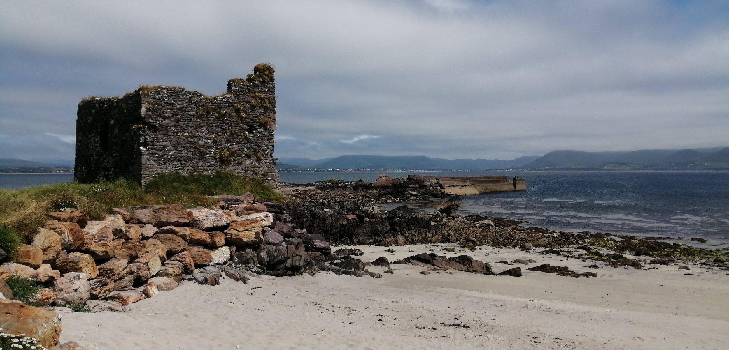
06. Ballinskelligs
The area surrounding Ballinskelligs is rich in cultural and natural heritage. With golden sands, rocky formations, and marshes, hours can be spent exploring the beautiful mixed landscape in the vicinity of Ballinskelligs Strand.
The ruins of MacCarthy’s Castle lie at the end of a distinctly separate ridge of sand from the main beach at Ballinskelligs. The castle sits on an isolated outcrop of rock that contains gentle folds and shows evidence of having been smoothed by glacial ice. This rock unit is attached to the mainland by a ridge of sand, known as a tombolo. The tombolo or sandspit is lined with a layer of pebbles that have been thrown onto the shore during particularly intense storm events. These pebbles and cobbles are of both local and non-local origin and include chalks, flints, and basalts likely from the seafloor west of the current coast, limestones and mudstones likely from Kerry, and granites that likely came from Galway (Coxon et al., 1983).
Snippets of the Iveragh's ancient past have been frozen into the rocks and by studying the information locked in these formations geologists have been able to unpick the area's past environment. At the rocky outcrop to the east of the beach, a series of ripple marks and an ancient dune deposit with cross-bedding are found. Cross-bedding is characterised by layers of sediment inclined to the horizontal, which form on sloping surfaces such as ripple and dunes. The presence of these ripple marks and cross-beds provides direct evidence of the river channels that once flowed across the area and allude to the vast floodplain that dominated the region over 385 million years ago. Here, a large section of dipping rock layers that were deformed during the mountain building can also be seen.
To learn more about Ballinskelligs check out our guide to the Skellig Way and take a guided tour of the Skelligs Monk Trail.
-

07. Reenroe
The standout feature at Reenroe is the sunken forest that is exposed at low tide. This drowned landscape of petrified trees and layers of peat is believed to be over 4,000 years old and offers a fascinating glimpse into the past environment of the area. This site provides unequivocal evidence of a time in the not-so-distant past when sea levels were lower than present, and forests flourished close to the ancient shoreline.
Throughout the Holocene, the geological age we are presently in that began about 11,600 years ago, the coastline of Iveragh has been experienced a gradual rise in sea level. In the middle Holocene, coastal woodlands, such as that at Reenroe, were flooded as rising seas inundated the land. Gradually, the peat deposits and surviving tree stumps were buried under sediment and sands as the tides abated and were preserved for thousands of years in this saline environment. In 2014, a particularly vicious cycle of storms stripped away layers of sand at Reenroe and revealed these remarkable petrified tree stumps.
An area of blanket bog can be explored by taking the Emlagh Loop (https://www.sportireland.ie/outdoors/walking/trails/emlagh-loop) through the Emlagh Bog behind Reenroe Strand. Blanket bogs support a rich and fascinating assemblage of species and are wonderful places to visit throughout the year to watch how the landscape changes from season to season, with browns and reds giving way to greens and splashes of wildflower colour, as the transition from winter to summer takes place.
The Reenroe Cliff Walk highlights some of the history and heritage of the area. Here, the short cliff sections are composed of Old Red Sandstones that are overlain by glacial deposits. A short detour down to one of the many pebble inlets will reveal purple bedrock that hosts many large pebble-sized clasts in a fine-grained rock. These are known as rip-up clasts. Rip-up clasts provide evidence of a river channel system that flowed over muddy and clay beds, sometimes removing pieces of the clayey sediment, and transporting them some distance. These clay fragments were eventually deposited downstream and through the accumulation of additional sediments, these clay sediments have been cemented to form mudstone clasts within the rock.
-

08. Inny Strand
Here the River Inny enters the sea at the Inny estuary, separating Inny Strand from the adjacent Reenroe Strand. To learn more about the nature, heritage, and history of the Inny River, listen to the wonderful Lyric Feature, Following the Inny with J.J. O’Shea.
The beach at Inny formed when the sand carried by the waves and tides was dumped due to a reduction in current flow as the seawater met the freshwater emerging out of the estuary. The barrier created by the deposition of this sand bar resulted in the formation of the lagoon behind the beach area. The area around the lagoon is dominated by salt marsh. Salt marshes are influenced by the tides and are periodically flooded by the sea and so contain a distinct assemblage of species that can survive regular immersion by the tides and the associated high salinity. Such specialist species include Sea Aster, salt marsh grasses, and Samphire.
The long curving beach at Inny is backed by quite an extensive dune system. Similar dune systems have been developing across the area throughout the Holocene Period, following the last glaciation, and consist of sand that is continually wind-blown and recycled. The dunes at Inny support a population of rare Petalwort, which contributed to the designation of the region as a Special Area of Conservation.
Dunes act as a physical protective barrier against severe wind, powerful waves, and storm events, shielding low lying regions from erosion and flooding. But dunes themselves are extremely delicate systems that are vulnerable to the elements and are set to come under increasing pressure as a result of increased storm events and sea level rise associated with climate change. Boulder rock armour has been placed at the base of the dune system to help preserve these dunes.
-

09. Lough Currane and the Cummeragh Valley
Some of the most spectacular features of glaciation on Iveragh are located within the picturesque Cummeragh Valley. Here lies an impressive moraine system composed of mounds of glacial deposits that were left behind by the progressive retreat of glacial ice (Bryant, 1974).
The area around Waterville was strongly influenced by glaciers that formed in the Reeks and overtopped the mountains of the valley, as well as corrie glaciers that formed on the slopes of the mountains that surround the Cummeragh Valley. These ice lobes pushed westwards down the mountains but as the ice melted and retreated, the mud, stones, and boulders carried by the ice was dumped to the ground. This ice retreat was not a simple event but involved many periods of stagnation and readvance, forming the undulating mound-like pattern across the area. These moraine deposits can be distinguished as the relatively smoother hills and slopes in comparison to the craggy mountains.
As these glaciers were melting the hummocky deposits trapped and dammed the meltwater, forming a series of lakes, of which Lough Currane, that drains into Ballinskelligs Bay, is the largest. The other lakes of the region include Isknagahiny Lough, Lough Namona, Clonnaghlin Lough and Derriana Lake and are renowned for their excellent salmon and trout fishing.
Lough Currane is a site of immense archaeological interest with the most significant site being Church Island. Church Island is associated with St. Fíonán Cam who is reputed to have founded a monastery there in the 6th century. Fionán Cam is an important figure in Kerry and descended from Conaire Cóem, High King of Munster. The site encompasses a graveyard and 12th century Romanesque church (Dunne & Dunne, 2012). The island is an OPW site and is accessible only by boat, which can be arranged locally. Sea Synergy also offers kayak and paddleboard tours of the Lough Currane.
-

10. Waterville
The beach at Waterville is dominated by large cobbles that have been rounded by the sea and thrown onto the shore during storm events. This beach has a steep profile with the cobbles tumbling down to the waters’ edge. The largest pebbles tend to be found near the top of the beach and smaller by the shore, with sand revealed at low tide. The presence of this large material at this site but not the nearby Inny and Reenroe strands is related to Waterville’s direct exposure to the dominant south-westerly winds.
The beach at Waterville is backed by towering cliffs of unconsolidated glacial deposits. These deposits are cut-throughs of the undulatory moraine systems that flow through the Cummeragh Valley and an amazing amount of information can be recovered from these unassuming piles of mud and stone.
These cliffs have a purple hue and are largely composed of stones that have a local origin, predominantly purple and green Old Red Sandstones, in addition to some white quartz fragments. The exposed cliff section shows a chaotic assemblage of material, with large boulders and much finer pebbles and gravel. On close examination, you may be able to distinguish a number of distinct units within the cliff face. In some places, it is unstratified and unsorted, which suggests that it was deposited directly by glacial ice, while in other places it is clearly layered and sorted, indicating deposition by flowing meltwater. The variation between the finer-grained layered material and the more massive unsorted units suggests that the retreat of these ice sheets was not simple but occurred in several cycles of melting and ice readvance (Evans et al., 2012).
The rocks within these units show imbrication in places, which occurs when the pebbles regularly overlap one another in a similar manner to roofing slates or toppled dominos. Imbrication acts as an indicator of the direction that the ice or in some cases meltwater was flowing. The large till units also show evidence of deformation, likely from being overridden by subsequent readvances of glacial ice, as well as periglacial involutions, where the sediment is deformed and reorganised due to frost action.
Sea Synergy run many trips and activities that explore this region.