
The Skellig Way
LOCATION: Ballinskelligs and Ducalla
LENGTH: 12km
DIFFICULTY: Difficult
PARKING: Ballinskelligs Beach OR Ducalla
A little bit about the area
Our map does not correspond to exact points or numbered signs along the trail. Instead, this map is seen as a companion for the area, filling you with information on what you might find and where you might find it. It will hopefully add to your enjoyment of this wonderful corner of Iveragh and help build the memories that will stay with you long after you leave.
The Skellig Way is a one-way trail which can be started from Ballinskelligs Beach car park, or from Ducalla car park at the memorial to the Liberator plane crash. For this map we are going to start in Ballinskelligs, where there are public toilets, ample parking, and a café to stock up on snacks for the journey. Ending in Ducalla, it is a short drive to ‘The Glen’. Here you can also indulge in some local hospitality, overlooking the spectacular St Finan's Bay with the Skellig Islands on the horizon.
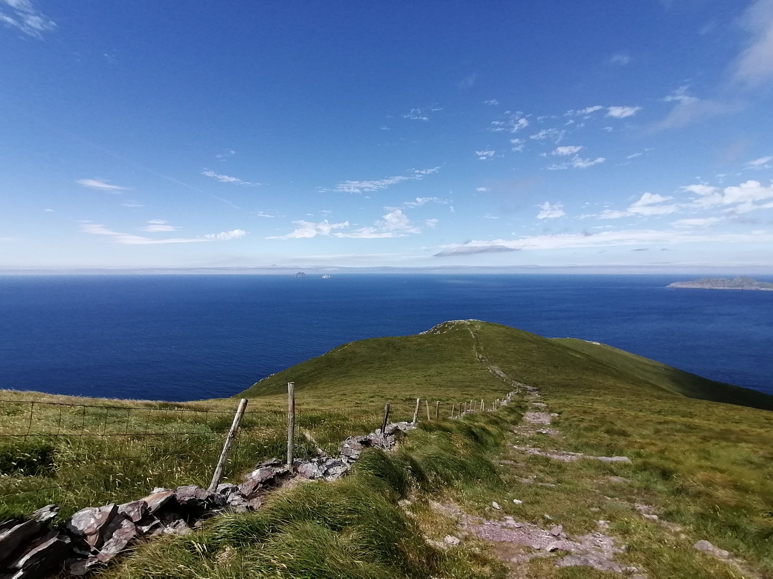
The 12km trail passes along rural tarmac roads, sheep grazed fields and some upland moors which can be boggy underfoot, especially after rainy days. Whichever way you choose to walk the route, you will be rewarded by some of the best views on Iveragh: dramatic cliffs, glistening bays and distant islands - not to mention colourful wildflowers, seabirds, our native common lizards and maybe even a little land-based whale watching.
Trails such as the Skellig Way, and many others that crisscross the Iveragh Peninsula, are only made possible with the kind cooperation of local landowners. Due to the presence of farm animals along the trail, dogs are not permitted.
HOW TO EXPERIENCE THE MAPS:
The map locations can be seen on your mobile device. Clicking on the square icon in the top right hand corner of the respective map to open the map in a web browser or Google maps app. Or you can click on the square in the top left of the map to follow it on this page.
TRAIL GUIDE:
Below the maps is the guide for the map and the selected points.
There is also an alternative Storymap:
The Skellig Way Guide
-

Start Point
The blue flag beach at Ballinskelligs is popular all year round. Whether it's enjoying a hot drink after a winter walk, or dipping in for a swim, it's a great spot that is sheltered from the powerful waves found elsewhere on the Iveragh coast.
Two carparks and wheelchair-accessible public toilets are available here. A lifeguard is on duty during the summer months only, but the brave volunteers of the Ballinskelligs Inshore Rescue are also based nearby. They safeguard locals and visitors who may get into difficulty in the bay or surrounding seas - a vital service for any coastal community.
-

Birdwatching
Along the trail, keep an eye out for winter wading birds from September to April. Brent Geese (Cadhan) and Turnstone (Piardálaí Trá) are just a two of the birds you may encounter around the beach area. They travel from colder northern countries to spend their winter on our milder shores and wetlands.
You might see Curlew (Crotach) around this area but also look for them in the cliff top fields beyond Cill Rialaig later in the journey. Large flocks may gather to mingle with sheep while probing the ground for tasty worms. Learn more about these feathered visitors in our Winter on Iveragh section.
Spring sees the return of other migrating birds, including Swallows (Fáinleog) and Sand Martins (Gabhlán Gainimh). The estuary between the beach and McCarthy's Castle is a great place to watch them zip low over the water, as they catch flying insects above the surface.
-

Skellig Monks Trail
The beginning of the walk overlaps with the 2km Skellig Monks Trail. This is a great walk for those looking to learn some of the history of the area. Guided tours are available for those looking to learn more about the monks that lived in the area in the past and built some of the iconic structures so synonymous with the area. The 16th century McCarthy's Castle and the 12th century Ballinskelligs Priory (also known as the Abbey) are located on this section of the trail and are well worth a look around.
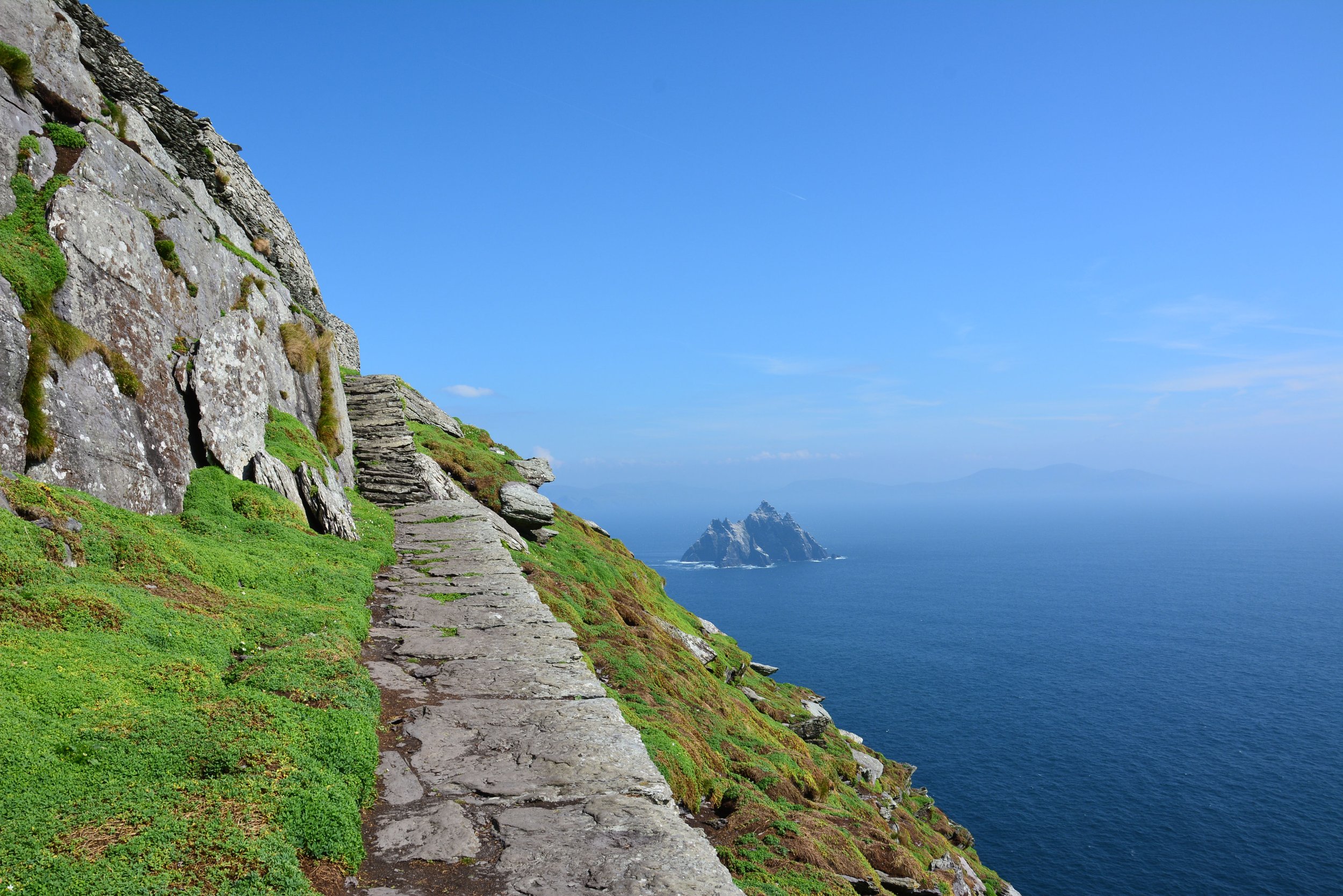
The Skellig Islands
The UNESCO Heritage Site of Sceilg Mhichíl (also known as Skellig Michael or Great Skellig) and Sceilig Bheag (Little Skellig) lie 12km off the coast of Iveragh and can be viewed from further south on this trail. The Skelligs’ influence can be found all over the area - Ballinskelligs comes from Baile an Sceilg meaning 'town of the Skelligs'. The Skellig Ring is the road that follows the spectacular coastline from Ballinskelligs via ‘The Glen’ to Portmagee.
Perhaps you will be lucky enough to book a space on one of the very popular boat trips that visit the Skellig Islands. Tours depart from Reen Pier in Ballinskelligs and need to be booked well in advance. Some trips circle the island to take in the breath-taking views, while others land on Skellig Michael. Landing and summiting the incredibly steep island is not for the faint hearted, so please seek advice from the tour operator before booking this option.

What's in a name?
Knowing the Irish name for a place, flower or animal can be a wonderful thing. Some names are beautifully descriptive while others explain the origin of a seemingly meaningless anglicised word.
Ballinskelligs (Baile an Sceilg) takes its name from the iconic islands with Sceilg meaning a splinter or steep rock. Further along the trail you pass through Reen. This comes from the Irish Rinn meaning a point or headland. Continuing uphill you reach Boolakeel which is from the Irish Buaile Uí Chuill or church booley, with ‘booleying’ being the practice of moving cattle from upland to lowland grazing with the seasons.
Logaimn.ie is a wonderful online resource to learn more about Irish place names. Wildflowers of Ireland provides the Irish name for some of the beautiful flora you will find on Iveragh. For birds, check out Birdwatch Ireland; Foclóir and Teanglann are good for animals and general vocabulary.

-

Coast Stories
Spend any time delving into the history of coastal areas and one thing that will undoubtedly appear are tales of smuggling, shipwrecks and pirates. Alcohol and other sought after goods were often brought ashore under the cover of darkness. Coastguard Stations were established in the 1820s, in an attempt to prevent such activities, one of which was established near Reen Pier, Ballinskelligs.
'900 - The Story of the Kerry Shipwrecks' is a fascinating piece by Radio Kerry that explores a number of shipwrecks. It includes audio interviews with those who have researched these incidents, including the sinking of the Lady Nelson off the Skelligs in 1809.
-

Common Lizards
The old stone walls and upland heath along the trail make for perfect lizard habitats. Ireland's only native lizard, they can grow up to 14cm long and hibernate through our colder winter months. Keep an eye out for them basking during sunny spells, but on a warm day, blink and you'll miss them! They can zip away quickly, which is important if you are trying to avoid being eaten by a hungry bird. See our lizards section for further information and a host of freely available resources, including fun stuff for kids.
-

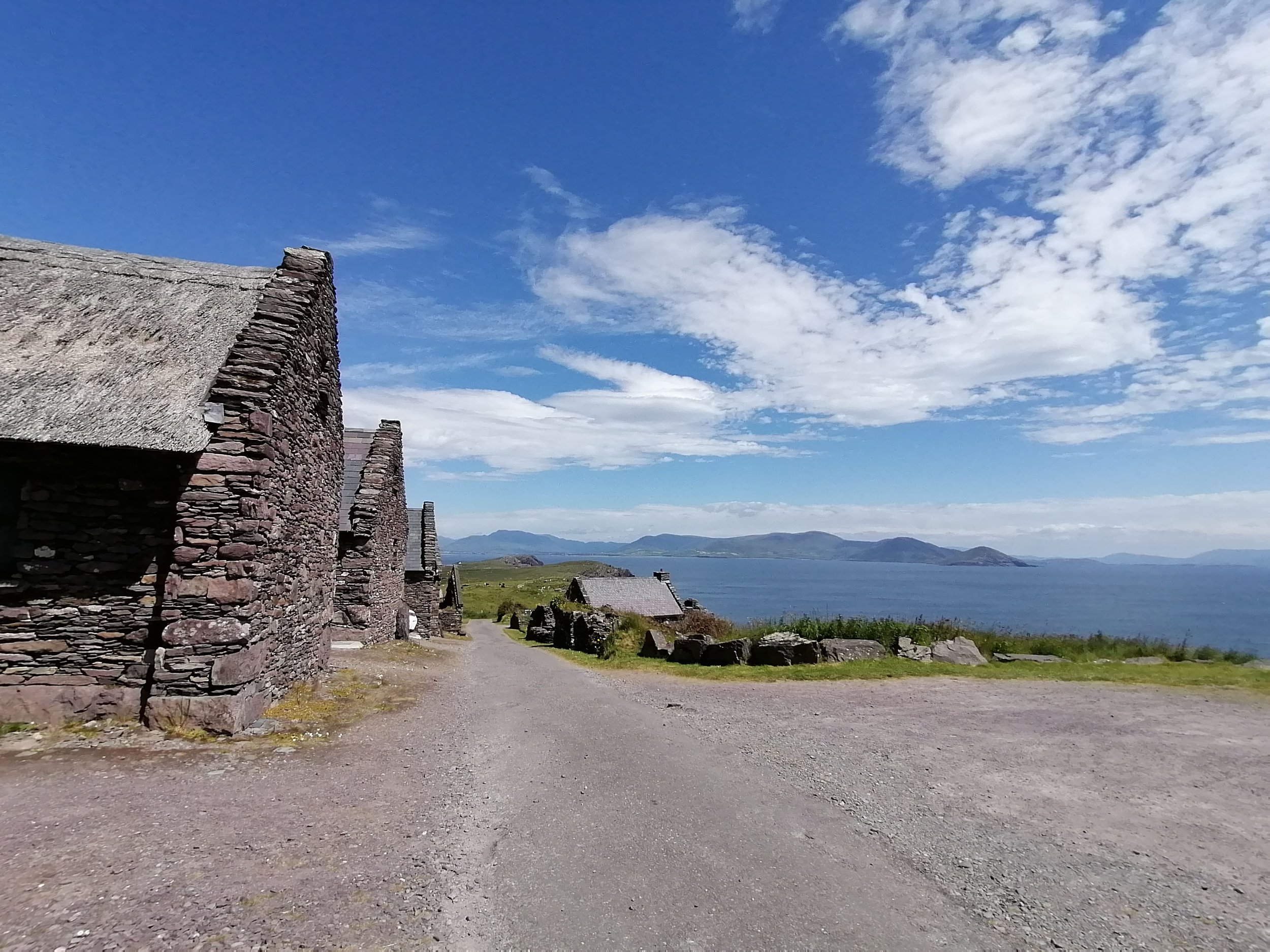
Cill Rialaig
As you continue along the roads out of Ballinskelligs, the trail rises, and you gain stunning views across Ballinskelligs Bay. You will pass through Cill Rialaig, an old famine village built around 1790. Abandoned and fallen to ruin, a number of small dwellings were restored and are now used as an artist's retreat.
Here, artists are immersed in the dramatic landscape and peaceful soundscape. The area also has a rich history of local musicians, poets and seanchaí, including the famous Seán Ó Conaill to draw on for inspiration.
-

Ruins
At various points along the trail, you will see the stone remains of dwellings and animal shelters, which vary from the pre-famine era to more recent times.
In the field across the road from the old school house, there is an early Christian site. A number of slab rocks are etched with crosses and there is evidence of a possible oratory along with other small buildings. A souterrain trench is also present, which may have been used to store food in the cooler underground temperatures. It is believed to have been built around the 8th century, or possibly earlier.
Two very distinctive ruins can be found at the high point of the trail. The smaller concrete structure is the ruin of a World War II lookout tower. The larger is the ruin of a Napoleonic era signal tower, built around 1804.
Structures such as these were built within sight of other headland towers (such as on neighbouring Hog's Head and Bray Head) with the intention of communicating in the event of a coastal attack by sea, or air in later years. You can learn more about these look out posts here and signal towers here.
-

Red-billed Chough
Iveragh is home to Ireland's rarest member of the crow family, the Red-billed Chough (Cág Cosdearg). When hiking the Skellig Way, listen for their distinctive 'keee-aawww' call and undulating flight pattern. Often travelling in pairs or small groups (appropriately called a 'chattering'), they have a distinctive curved red bill and bright red legs. The Skellig Way is located on the Iveragh ‘Special Protection Area’ (SPA), where the coastal cliff faces and well-grazed farmland provides them with ample nest sites and foraging opportunities. Read more about choughs here.

Geology
Skellig Michael and Little Skellig are composed of the same Old Red Sandstone Formation that covers the mainland of the Iveragh Peninsula. Around 320 to 290 million years ago, Ireland was caught up in a collision between two continental plates. As the plates collided, the Old Red Sandstones were compressed, forcing the rocks to crumple, fold, and lift upwards to create mountains and valleys. This mountain building event is called the Variscan Orogeny and formed the mountain ranges found on the Iveragh Peninsula including the Dunkerron Mountains and the Macgillycuddy’s Reeks. The Skellig Islands existed as a part of these mountain belts, and following the Variscan Orogeny would have remained attached to the mainland as a continuation of the promontory at Bolus Head.

During the Ice Age, a period lasting from about 2.6 million to 11,700 years ago, Ireland was periodically covered by vast ice sheets. At the last glacial maximum, so much water was locked up in ice sheets across the world that global sea level was about 120m lower than it is today. However, when the Ice Age came to an end, these ice sheets quickly melted and huge volumes of meltwater drained into the ocean, causing sea level to rise rapidly. It was during this sea level rise that the Skelligs were isolated from the mainland, as the lower lying land was flooded and only the tallest peaks remained above the water.
Since then, these islands have experienced the full ferocity of the Atlantic Ocean and have endured thousands of years of storm-battering and wave-smashing. This tumultuous sea has sculpted and eroded the islands to create the jagged pyramidal crags that rise sheer out of the sea today.
-

Islands
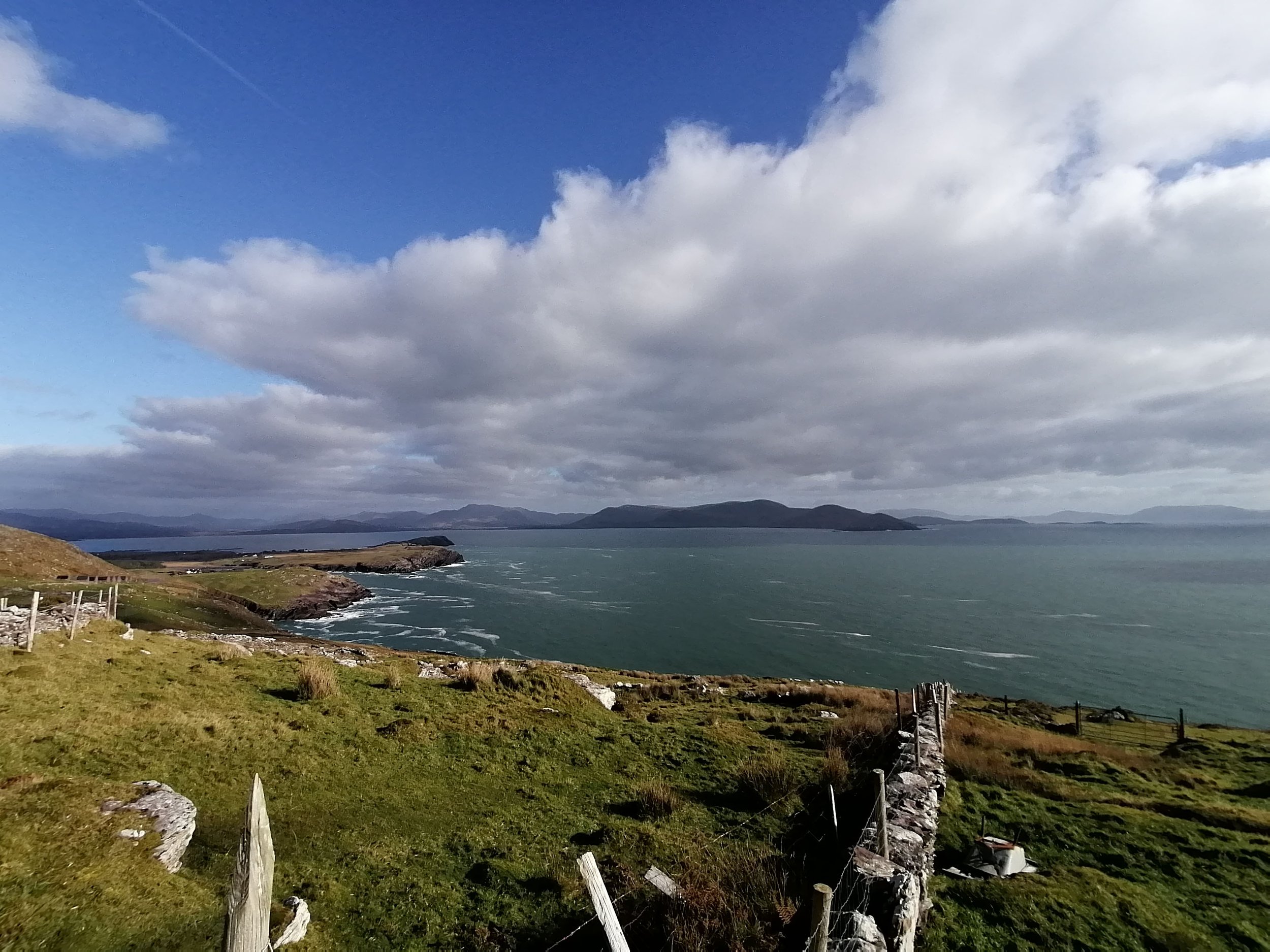
There are a number of islands visible from the Skellig Way trail. If starting in Ballinskelligs, the first you will see is Horse Island (Oileán na gCapall), which has remained uninhabited since the 1950s.
From the higher point of the trail you will have wonderful views of the famous Skellig Islands with their dramatic, jagged shapes sitting on the horizon. Skellig Michael has its ancient monastic settlement and lighthouses while Little Skellig is home to one of the largest Northern Gannet (Gainéad) colonies in the world. In spring, watch Little Skellig grow whiter as the nesting season begins and guano (a fancy name for bird poo) accumulates along with the increase in bird numbers.
To the south west, off the tip of Moyrisk on the mainland, you will see Puffin Island. This is an uninhabited nature reserve and ‘Special Protection Area’ (SPA). Many seabirds nest on the islands and cliffs around the area and, for this reason, Iveragh's cliffs from Rossbeigh on the north coast to Lamb’s Head in the southwest are designated as a ‘Special Protection Area’ (SPA).
-
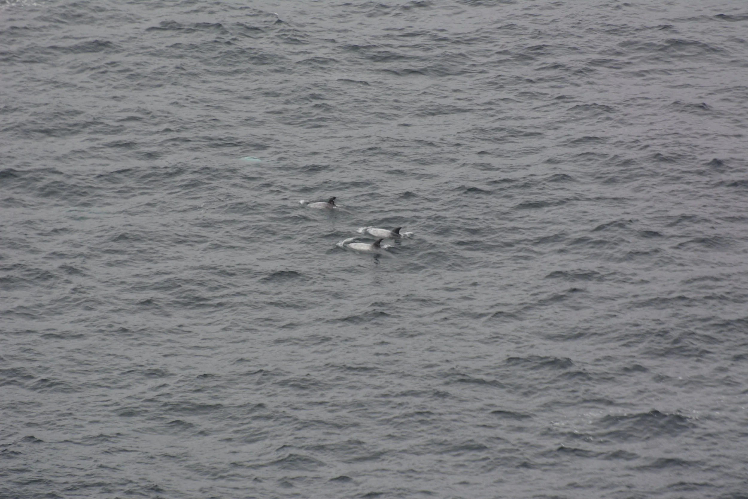
Marine Mammals
The trail follows the coastline for much of the route and it's always worth keeping an eye out for marine mammals. Seals (Rón) might be found hauled out on rocky shorelines or bobbing in the sheltered water of inlets below the cliffs.
A fleeting glimpse of a small fin may be all you'll spy of the little 1.5m Harbour Porpoise (Mhuc Mhara). A larger animal is the Common Dolphin (Deilf Choiteann) - abundant around Irish coastlines and often seen travelling in groups. Larger again is the Bottlenose Dolphin (Deilf Bholgshrónach) - with adults over 3m in length.
Ireland is also home to several species of whale with the most common sightings coming from the small and speedy Minke Whale (Droimeiteach Beag). Humpbacks (Míol Mór Dronnach) and the mighty Fin Whale (Droimeiteach) - the second largest whale in the world, after the Blue Whale (Míol Mór Gorm), also frequent Irish waters. Look for large flocks of seabirds diving and gathering over the water. This is often a sign of a shoal of fish and marine mammals frequently join the buffet in the water beneath these bird flocks.
The best plan is to find a safe and comfortable spot to sit while watching the water for a while. Take a look at our section on dolphins and whales for much more information on the species you can spot off of Iveragh’s coastline. You can report your cetacean (porpoises, dolphins and whales) sightings to the Irish Whale and Dolphin Group here.
-

St Finan's Bay
Firstly, you may be shouting "It's St Finian not St Finan!" but this is something of a debate as both spellings can be found in old and recent texts. A wonderful blog by Driftwood Surf Cafe explains the story nicely and gives an insight into St Finan himself. A monk born in Kerry around 530AD, he regularly rowed the 12km from the monastery on Skellig Michael to the mainland to perform mass. The bay seen from the north section of the trail now bears his name, as does the holy well located on the road to the west of the beach there.
A ritual of a different kind can be observed here in the winter, as local surfers take on some of Iveragh's biggest waves. You might be skilled enough to partake but if not, take in the spectacle while exploring the seashore. With the turquoise waves and Skelligs on the horizon, it's a wonderful spot to switch off and relax.
-

Wildflowers
Spring and early summer are wonderful times to admire wildflowers. Pollinators make the most of the bounty and can be seen busily commuting between flowers.
April sees the emergence of pink blankets of Sea Thrift (Rabhán) while the purple heads of Sheep's-bit Scabious (Duán na gCaorach) follow on in May. The farmland section is a good place to keep an eye out for orchids - including the Heath Spotted-orchid (Na Circíní). This boggy area is also where to search for specialist species such as the yellow Bog Asphodel (Sciollam na Móna) or peach Bog Pimpernel (Falcaire Corraigh).
The Wildflowers of Ireland website is a useful resource for identifying flowers and learning their Irish names. Remember: look, don’t touch - many of our wildflowers are rare so make sure to leave them unharmed.
-

An Ghaeltacht
Ballinskelligs, ‘The Glen’, and their surrounds are some of the strongest Irish speaking areas of Iveragh. Scoil an Ghleanna (arguably the school with the best view in Ireland!) is empowering the next generation with the Irish language, while Coláiste Mhichíl runs popular summer schools.
Organisations such as Tascfhórsa Uíbh Ráthaigh and Brí Uíbh Ráthaigh are trying to reinvigorate the Iveragh Gaeltacht. Supporting local initiatives, education programs and encouraging Irish speakers to move to Iveragh are just some of the projects underway. TG4 took a look at some of the work being done in ‘The Glen’ as part of their 'Bailte' tv series - watch it here.


Liberator Memorial
Whether you start or finish at the Ducalla carpark, you will notice the memorial to the US Navy Liberator plane crash. This isolated location was chosen to mark the loss of 11 lives on the 27th of February 1944. The plane disappeared without trace, likely lost to the seas off Bolus Head. The only clue to its fate were reports from Skellig Michael lighthouse workers of a plane flying low overhead. Signs that it had hit rocks at the peak of the island indicate that it was either already in trouble or sustained damage that led to disaster.