
Valentia Island Geotrail
LOCATION: Dohilla, Valentia
LENGTH: 2km
DIFFICULTY: Easy to Difficult
PARKING: Valentia Island Lighthouse
A little bit about the trail
The route is easygoing and covers a distance of roughly 1 km (one way). The trail is best completed at low tide and some scrambles over rough and uneven rocky surfaces are required. Avoid the rock section during periods of strong wave action and take caution on slippery rock surfaces. Be sure to check the tidal forecast as some features will be submerged at high tide. There are no waymarkers for this route. Part of the fun is hunting for each of the geologic features!
Geologic Background
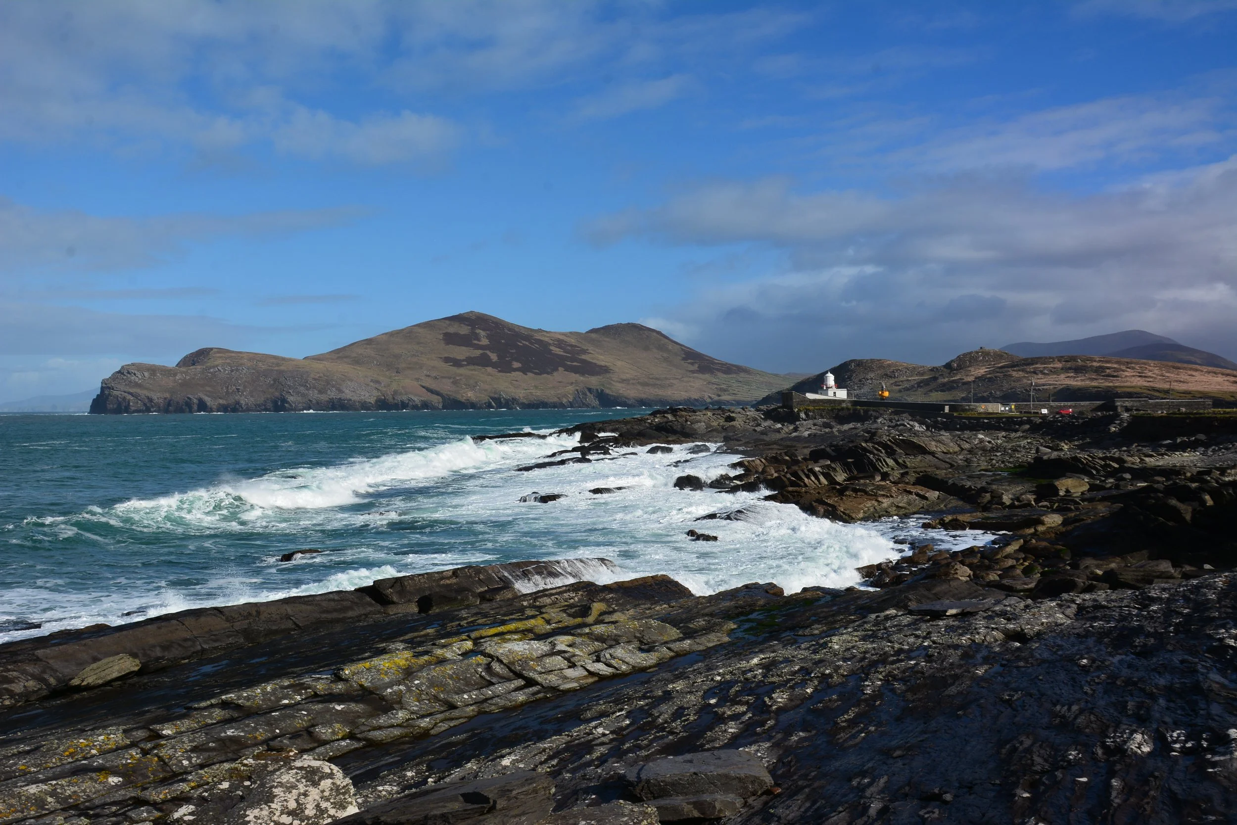
Valentia Island hosts a rich and diverse range of geological features in a small area. These features reveal the story of a landscape shaped by volcanoes, scorching deserts, and icy wastes. There are few places on the Iveragh Peninsula with the ability to transport you back to the world of the Devonian more than Valentia Island. Along the rocky shore by Valentia lighthouse, evidence of the alternately wet and dry floodplain environment and the river channels which once flowed across the area are visible in remarkably three-dimensional features. The rocks along this geotrail allow you to immerse yourself in the world that surrounded Valentia's famous tetrapod, one of the first vertebrates in the world to walk on land.
Along this trail, the most common rocks are sedimentary rocks such as siltstone and sandstone which were deposited in the Devonian Period. At Valentia Island the rocks are composed of layers of purple to green sandstones, siltstones, and mudstones. The different colours of the rocks reflect different depositional environments.
Rocks that appear green and grey would have been deposited in areas that were consistently covered in water such as river channels and ponds.
The purple rocks found in the area would have been deposited in drier environments, such as along river banks and between river channels.
Across the section areas of reddish-brown rock also appear. This red colour is due to oxidation, which is the chemical reaction of atmospheric oxygen with iron in the rock forming rust.
As you explore the map of Valentia’s north coast below, you will also gain insight into the immense geological force of plate tectonics and the sculpting power of glacial ice.
HOW TO EXPERIENCE THE MAPS:
The map locations can be seen on your mobile device. Clicking on the square icon in the top right hand corner of the respective map to open the map in a web browser or Google maps app. Or you can click on the square in the top left of the map to follow it on this page.
TRAIL GUIDE:
Below the maps is the guide for the map and the selected points.
There is also an alternative Storymap:
Valentia Island Geotrail
1. Myriapod Trackway
At the first stop you will get an insight into some of the animals that roamed the land during the Devonian. Here myriapod trackways have been found. These footprints are evidence of invertebrates, similar to millipedes which moved, fed and excavated burrows in the muddy sediments. Myriapods were one of the first animals to become established on land and would have been accompanied by mites and scorpion-like creatures. Valentia’s tetrapods were yet to complete the transition to land. The body fossil record of myriapods is sparse due to the poor preservation of their light and thin exoskeletons, but trackways have been noted on the island since the first geologic surveys in 1861 (Beeke Jukes, et al., 1861). (Jukes, et al., 1861)

2. Plant Fossils
Stop 2 provides evidence of the plant life which would have coexisted with the early land animals. Here a number of fossilised plant stems are found within a pale green siltstone unit. The alignment of the stems and the green colour of the rock suggests that they were transported and deposited by flowing water, likely as part of a river channel. The black colour of the fossils is due to carbonisation, a process in which only the carbon of an organisms remains after it has been subjected to great heat or pressure over time.
The plant is likely Archaeopteris fissilis. Archaeopteris was one of the first trees on Earth and was widespread during the Devonian, being present from the equator to near the poles. Archaeopteris fissilis had spiky leaves and grew up to 30 metres high. These early trees would have been accompanied by ferns and horsetails.
Archeopteris and early land plants likely played a big role in in altering Earth’s climate and environment. The development of the first major root systems impacted soil chemistry and stabilised soil. The uptake of carbon dioxide and release of oxygen by these plants is also believed to have had major impacts on the Earth’s atmospheric conditions. Decreasing carbon dioxide levels had a feedback on global temperature and resulted in widespread cooling (Alego et al., 2001; Baars, 2017). The spread of plants was also important for providing a new food source, allowing animals to exploit new habitats.

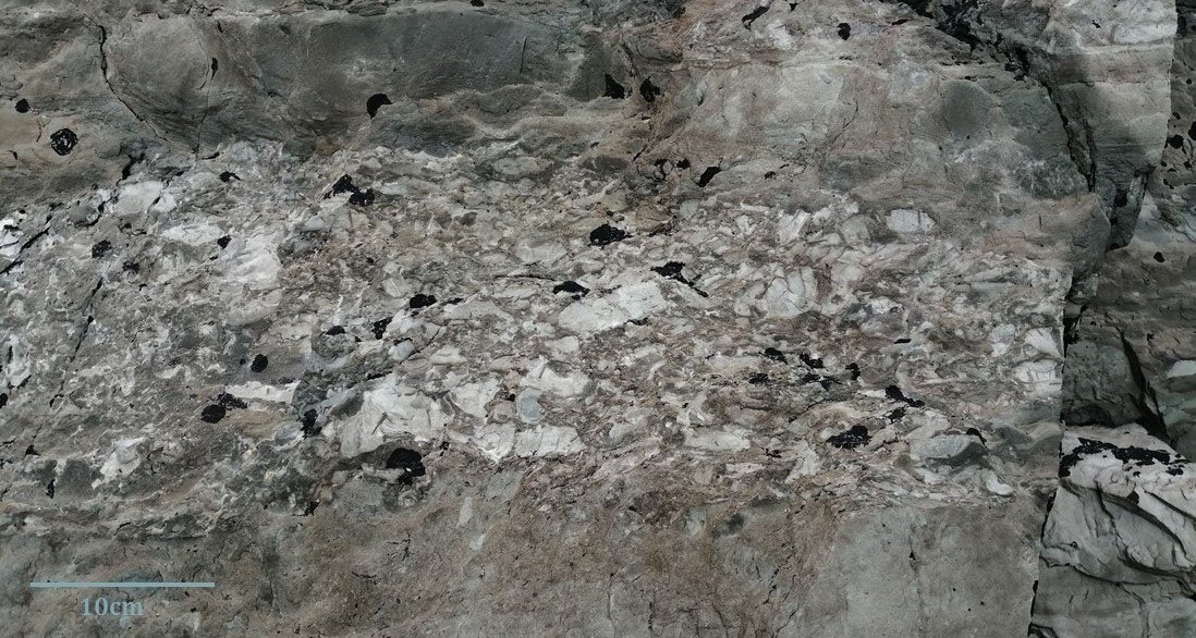
3. Rip-up clast bed
At Stop 3 further evidence of the river channels which once flowed through the area is found. Here there is a great example of a sedimentary feature called a rip-up clast bed. Rip-up clast beds form when the action of flowing water in a high energy river or stream detaches mud and clay from the bottom of the riverbed. These detached clasts are then transported by the flowing water of the river and deposited in a different area, often in lower energy sections of the river such as along outer banks or at the inside of bends. This happens similarly to the way you would expect pebbles to be transported by rivers and streams today.

-

4. Cross-Bedding
Across from the rip-up clast bed a continuation of this river system can be imagined. Here a large blocky unit stands out of the rocks. This unit contains clear evidence of flowing water in the form of a common sedimentary feature called cross-bedding. Cross-bedding is characterised by layers of sediment inclined to the horizontal which form on sloping surfaces such as ripple marks and dunes. The large size of this deposit suggests that it is a dune which formed within a river channel. The dip direction of the bedding acts as an indicator of past water flow direction as the steep faces always tilt down-current. Here the deposits are inclined to the south-east suggesting that the water once flowed towards where the road now lies.
-

5. Mountain Building
During the Devonian, the sediments would have been deposited more or less horizontally. But looking out over the rocks along this section of coastline, the landscape appears markedly uneven with beds dipping at various angles. This is due to the continental collision that occurred during the Variscan Orogeny.
Two major things happened to the rocks as the continents collided. The first is that due to the compression and squeezing of the rocks there was on overall shortening of the area by about 40-50% (Cooper et al., 1986; Meere, 1995). This compression of the rocks resulted in the crinkled texture that can be seen across the rocks. In geology this kind of texture formed from tectonic activity is known as cleavage.
The second thing which happened was that the once flat lying rocks became distinctly folded and tilted into a series of gentle u-shaped and n-shaped folds under huge forces over millions of years. This is why the rocks of the area appear crumpled and undulated rocks today.
-

6. Desiccation cracks
The next stop emphasises the hot and arid climate of the Devonian, which is quite different to the current Irish climate. Here polygonal cracks can be seen on the surface of a green siltstone unit. These are desiccation cracks or mudcracks. Mudcracks form from the shrinkage and contraction of water-saturated, clay rich sediment due to dehydration as evaporation occurs. These features would have been preserved by the influx of later sediment and turned into solid rock, only to be exposed at the surface again some 380 million years later. The presence of mudcracks indicates that the sediment experienced quite rapid alteration between wet and dry conditions. This kind of environment with temporary puddles and shallow pools, alongside longer lasting river channels is typical of floodplains. A floodplain environment would also readily supply large volumes of sediment which could quickly cover the surface of the cracks and aid in preservation.
7. Dolerite Dyke
At Stop 7 a new rock type enters the picture. In the Devonian sedimentary rocks were not the only rocks actively forming in the area. Although less common, volcanic rocks formed as continental plates pulled apart and fractured, allowing magma to rise to the surface. Along this stretch of coastline a dolerite dyke can be found. Dykes form when molten lava seeps into the surrounding rock and solidifies below the Earth’s surface. Dykes often cut across structures such as bedding in the original rock. Dolerite is distinguished by its dark colour and usually appears black to green. These volcanic rocks are a testament to more violent times in the area’s history.
Along this trail a picture of this area in the Devonian as a very different environment to the coastal landscape of today has been constructed. Terrestrial life was dominated by large bugs which would have enjoyed a relatively predator free lifestyle. Plants were expanding on land and a newly established forest biome was appearing. The landscape itself was dominated by river, streams, and ponds. Nearby volcanic activity would have contributed to the unfamiliarity of the landscape, with both violent ashy eruptions engulfing the sky and more effusive intrusions seeping up through fractured rock. It is in this floodplain environment that Valentia Island’s tetrapods took their first tentative steps onto land.

8. Pebble beach
The final two stops on the walk places you at the most recent period in geological time. Here you can see two things: a small section of pebble beach and glacial till.
The large size of the pebbles on the beach indicate that this is a high energy environment which is often subject to strong waves. The smooth rounded shape of the pebbles shows that these rocks have been eroded over time as they were rolled and abraded by the action of these waves. There are five main colours of pebbles on the beach green, grey, red, and purple which are all sandstones and siltstones and white which are quartz. The different colours in the sandstones and siltstones represents different formational environments as already noticed in the outcrop.

9. Glacial Deposits
During the Last Glacial Maximum, Valentia would have been covered in an ice sheet over 600m thick. The best evidence for the presence of this powerful ice body is now contained within the somewhat unassuming banks that lie between the rocks and the road. These deposits, known as till, formed when the soil and rock debris scoured by the ice as it moved across the land were dumped as glaciers melted and retreated. Till consists of an unsorted mix of clay, sand, pebbles and boulders.
Looking closely at the till, you will notice that the same colours rocks are also present in the pebble beach. This suggests that the rocks were not transported far by the ice and also that the pebbles on the beach haven’t been transported far by the ocean, but were rather sourced from the underlying bedrock. In contrast to the smooth rocks on the beach, the rocks in the till are overwhelmingly angular. This is because the rocks in the till have been ripped and shattered from the bedrock by ice and were preserved within the cold sediment units without much further erosion.
