
Valentia Island & Over the Water Geosites
The Geologic Story
The landscape of Iveragh has been shaped by geological forces over hundreds of millions of years. Over the past 390 million years the area has been covered by hot deserts, shallow tropical seas, and thick ice sheets. These events have been recorded within the rocks and geologists use this hard evidence to reveal the landscapes, environments, and climates of the past. The area around Valentia and ‘Over the Water’ from Cahersiveen tell a captivating part of the Iveragh story. To learn more about this remarkable story read our Geologic History of the Iveragh Peninsula.
The map above highlights some of the best places to take in the extraordinary geology and see some spectacular scenery for yourself.
HOW TO EXPERIENCE THE MAPS:
The map locations can be seen on your mobile device. Clicking on the square icon in the top right hand corner of the respective map to open the map in a web browser or Google maps app. Or you can click on the square in the top left of the map to view it on this page.
TRAIL GUIDE:
Below the maps is the guide for the map and the selected points.
There is also an alternative Storymap:
Valentia Island & Over the Water Geosites
1. Valentia Lighthouse Coast
There are few places on the Iveragh Peninsula with the ability to transport you back to the world of the Devonian more than Valentia Island. Along the rocky shore by Valentia lighthouse, evidence of the alternately wet and dry floodplain environment and the river channels which once flowed across the area are visible in remarkably three-dimensional features. Animal and plant life within the desert and floodplain landscape of the Devonian was quite sparse and far less diverse than today. However, the Devonian was a period of immense change and progress that saw the expansion of plants and forests across the land, an explosion in marine life and reefs, and critically the movement of the first invertebrates onto land. Learn more about the plants and animals of the time and get lost in this unfamiliar world. A detailed guide to the geology and features present along this stretch of coastline can be found here

A trip to the lighthouse at Cromwell’s Point is a must when visiting this site. The lighthouse was originally the site of a 17th Century Cromwellian Fort with the 19th century lighthouse building being a later addition. The first light was established in 1841 and a lighthouse keeper lived on site until 1947 when the lighthouse was automated. Take time to admire the dramatic Atlantic coastline from the lighthouse tower balcony which offers spectacular views of Beginish Island and Doulus Head. The Lighthouse has an interactive museum, tearoom, bathroom facilities, and parking. To find out more about Valentia’s Islands lighthouse keeping tradition and book a locally guided tour visit the Valentia Island Lighthouse website.
2. Tetrapod Trackway
Towards the end of Devonian, an amazing transition began as tetrapod amphibians emerged and vertebrates began to colonise the land. The tetrapod trackways at Dohilla are amongst the most significant fossils in Ireland. These footprints were left in the sediment around 385 million years ago (that’s about 140 million years before the first dinosaurs!) (Williams et al., 1997; Williams et al., 2000) when tetrapods moved sluggishly along river channels across the muddy floodplain.
Early tetrapods evolved from fish and had crocodile-like heads and dentitions, raised eyes, and adaptations for better weight support and substrate locomotion. These creatures would have somewhat resembled modern salamander and were between 0.5-1m long. Six sets of trackways have been recorded at this site and some have evidence of central grooves which formed as the belly and tail of this animal dragged along the sediment surface (Stössel, 1995; Stössel et al., 2016). The adaptation to walk on the land is one of the most important evolutionary steps and this site offers a remarkable snapshot into a key moment in Earth’s history when this transition was occurring.
Look out for the ripple marks found just above the rock surface containing the tetrapod trackway. The ripple marks formed through the deposition and transport of sediment by the currents in an ancient river. These ripples were buried by a subsequent influx of sediment and hardened into solid rock, only to be exposed at the surface again some 385 million years later.
While these trackways were officially first discovered by an undergraduate student Ivan Stössel in 1992, anecdotal evidence indicates that during the early part of the 20th century the area was locally referred to as ‘Carraig na Ghur’ which translates to ‘rock of the hooves’ indicating that the fossils were exposed and locally known by this time.
The tetrapod trackway is a Natural Heritage site and an information board has been produced in conjunction with the Geological Survey of Ireland.

3. Valentia Slate
The lowermost and oldest unit of the Old Red Sandstone on the Iveragh Peninsula, known as the Valentia Slate Formation, is found at Valentia Slate Quarry. During the mountain building event mudstones and siltstones were metamorphosed into slate under immense pressure. During metamorphism the fine-grained clay and sands were realigned in a parallel orientation to form a rock that splits readily into thin slabs, making it very useful for construction.
Valentia Slate opened in 1816 and has been a working quarry on and off since that time making it the oldest operational quarry in Ireland. Over this time, the slate extracted from the quarry has been used in many famous buildings including the Paris Opera House and St. Paul’s Cathedral. Today the quarry produces a range of bespoke products including roofing, furniture, headstones.
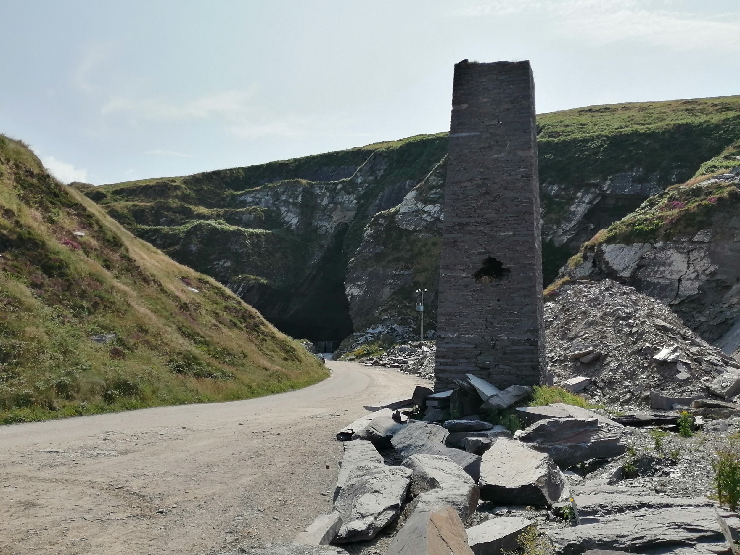
Excavated into the slope of Geokaun Mountain the quarry provides unbeatable views of the surrounding landscape and it is an excellent vantage point to view the Blasket Islands, Beginish Island, and Doulous Head.
You can book a guided tour of the quarry where you can explore the underground mine and learn more about its fascinating history here.
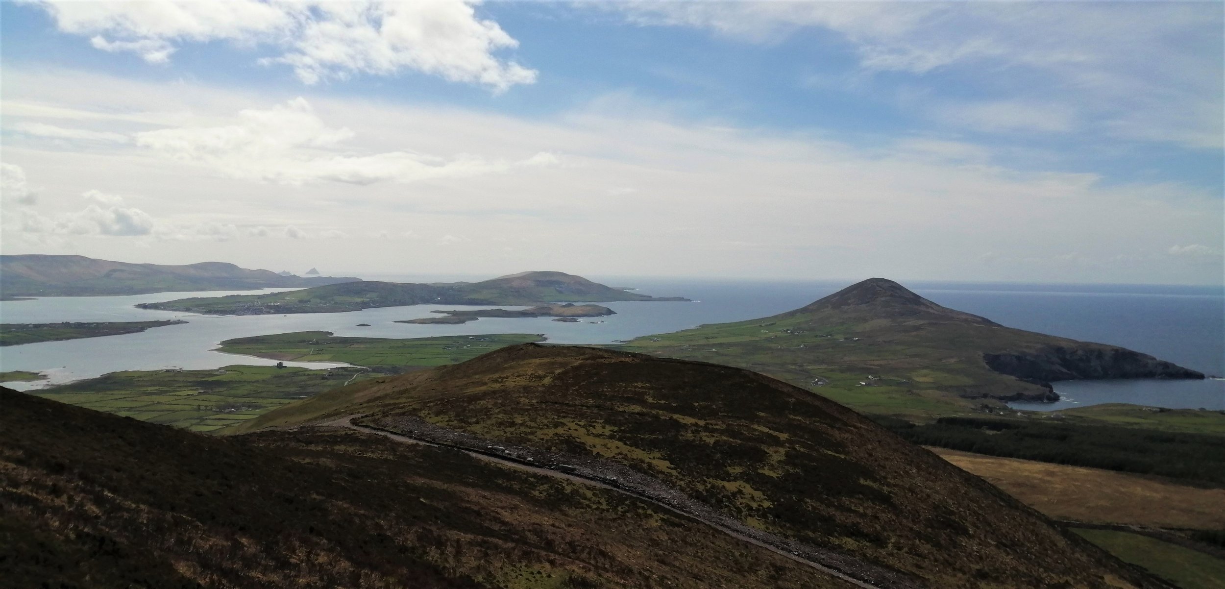
4. Geokaun and Fogher Cliffs
Geokaun is Valentia Islands' highest point and offers 360-degree views of the surrounding landscape including the Skelligs Islands, the Dingle Peninsula, and Blasket Islands, Beginish Island, Cahersiveen, Portmagee, and the MacGillycuddy’s Reeks. There are three viewing platforms along the route each with a series of information plaques where you can learn more about the history, heritage, geology, flora, and fauna of the Island. This amenity is accessible to all with options to walk or drive to the summit. Find out more here. Geokaun is also a designated Wild Atlantic Way Discovery Point .
Along the northern face of Geokaun, the Fogher Cliffs plunge into the sea, exposing millions of years of Earth's history in the rock layers. Imagine the time taken to build these formidable cliffs. Each of these layers represents an individual deposition event, with the interface between each layer representing an area of sediment which was once exposed to the surface. While these layers were originally deposited horizontally across a flat floodplain environment, some of these layers have clearly been deformed during the folding and tilting of the mountain building.
The Fogher Cliffs formed through the repeated action of waves pounding against the coastline since the last glacial period. Below these cliffs, a wave-cut platform can be seen. This platform formed as waves cut notches into the cliff face between the high and low watermark. As the notch grows bigger it destabilises the overlying rocks causing collapse and cliff retreat and leaving behind these level platforms.
During the continental collisional event, deep vertical fractures formed throughout the rock, and the presence of these fractures can be seen along the cliff face where the rocks have clearly fallen along vertical planes.

5. Glanleam
The secluded hollow at Glanleam has a tectonic origin. A large-scale fault known as the Coomnacronia fault runs along the Fertha River past Cahersiveen and over to Glanleam.
The presence of this fault weakened the structure of the rock and makes it more susceptible to erosion. As a result of this relationship, the sheltered pocket at Glanleam has been created which allows the subtropical garden a Glanleam House (http://www.valentiaisland.ie/explore-valentia/glanleam-subtropical-gardens/) to flourish. The sheltered nature of the bay means that it is protected from the brunt of the strong waves rolling in from the Atlantic which attack much of the storm-shredded western coast of the island. Instead, the low-energy waves that reach the bay preferentially deposit material to form a fine-grained sandy beach. The water is shallow and crystal clear, making Glanleam a delicate spot along an often wildly beautiful coastline.

While it is quite difficult to fathom the scale of the huge ice sheets which once ravaged the area, the cliffs of glacial deposits lining the western margin of Glanleam give an indication of the immense power of these ice bodies. These glacial deposits, known as till, are the most widespread evidence of the last glaciation and blanket much of the low-lying land across the peninsula, although they are often only visible in the coastal sections where they have been exposed by the waves. These imposing unconsolidated cliffs are all the more impressive for their relatively recent formation, geologically speaking.
6. Culoo Rock
This site is completely at the mercy of the swells from the Atlantic and is one that’s best left for a calm day. However, its hyper-exposed aspect has created a ravaged and dramatic stretch of coastline. With many inlets, craggy cliffs, and massive blocks of rock thrown onto the rocky shoreline, it’s a place to experience the full force of the power of the Atlantic.
This site is home to a less famous, but nonetheless remarkable tetrapod trackway. Located just to the south of the small inlet on the eastern side of Culoo Head, there are two trackways, comprising about 80 imprints (Stössel et al., 2016). These are believed to have been made by a similar creature as the Dohilla Tetrapod but smaller, perhaps a juvenile. These trackways were found in a rock that is composed of deposits from a floodplain channel, reaffirming that the Valentia tetrapods remained firmly tied to the water throughout the Devonian.
On calm days just west of Culoo Rock is a Pol Grom (Irish: Blue Pool), a natural rock pool, which will entice the brave in for an unforgettable dip. Look out for crumbled rock layers that were deformed during the mountain building and areas of rocks with unusual rust-coloured formations. This rust is formed through a weathering process called oxidation, where oxygen reacts with the iron in the rock to create rust.
To get to Culoo Rock follow signs for St. Brendan’s Well. Once at the well, cross over the stile and head east across the field for about 600m.

7. Bray Head
The Bray Head Loop Walk offers spectacular views of the Portmagee Channel, the Kerry Cliffs, Puffin Island, and the Skelligs. Bray Head is lined by steep cliffs and is an excellent place to see the impacts of erosion on the coastline. The base of the cliff is scattered with sea stumps, arches and there has been significant slumping of large areas of rock on the southern slopes of the cliff.
About 400m to the east of the Bray Head car park, in a small bay known as Foilhomurrum Bay, copper mineralisation can be spotted near the base of the cliffs. This copper deposit is found within a quartz vein. These deposits form as mineral-rich fluids enter fissures and cracks in the rocks. As these fluids travel through the cracks they cool and crystalised into hard mineral deposits.

The area containing the copper is instantly spotted from the turquoise staining that surrounds it. This turquoise staining comes from the presence of the mineral malachite. Malachite forms from the weathering of copper deposits and often serves as a clear indicator for the presence of copper. Foilhomurrum Bay was mined for copper and produced 65 tons of ore in 1861 and 34 tons in 1862, after which no further records of mining activity are found (Grenville, 1922).
Foilhomurrum Bay is also famous for being the site where the first transatlantic telegraph cable was laid between Valentia and Newfoundland in 1958. Learn more about the story of the Trans-Atlantic Cable at Valentia Transatlantic Cable Foundation (https://valentiacable.com/).
8. Beginish Island
Beginish or ‘Beiginis’ in Irish which translates as ‘Little Island’ is situated to the north of Valentia Island. Although small, it’s home to some fascinating geologic features and has huge cultural significance. Beginish contains archaeological evidence of Viking settlement between the 9th and 12th centuries, consisting of a circular stone dwelling, outhouse, and midden. The nearby Church Island is home to a 7th century Monastery with an oratory and hut, holy well, and shrine.
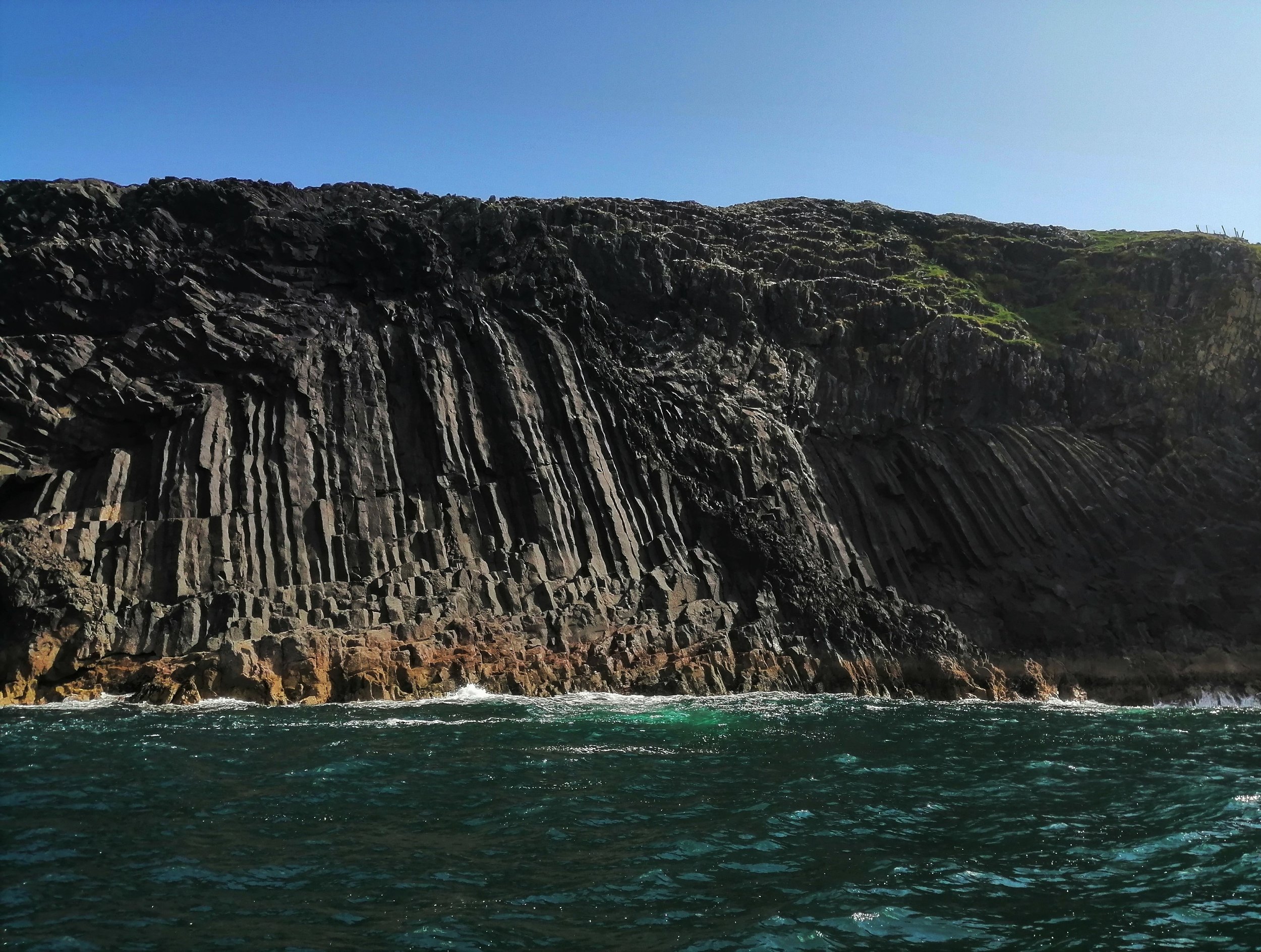
The largest area of volcanic rocks on the peninsula is found at Beginish Island. These rocks are gabbros and dolerites which were deposited below the surface as a sill. The dolerite and gabbro intrusion is exposed across large areas of Beginish as well as on the tiny Lamb Island to the north. At Beginish Island the dolerite intrusion shows columnar jointing, like that found at the Giant’s Causeway. These columns form during the cooling and contraction of molten rock material. As the rock contracts, fractures form and the intersection of these cracks results in the regular array of columns. The intrusion also shows chilled margins at the contact with the sedimentary rocks. These are glassy or fine-grained zones along the outside of the intrusion which cooled faster than the rest of the rock due to contact with the colder rock. Contact metamorphism occurred for several metres adjacent to the sill as the scorching intrusion heated up the surrounding rock and altered the rocks.
Of particular interest, is a raised beach deposit along the island's north coast. This provides direct evidence of a time when the relative sea level was higher than today. At Beginish the raised beach is interbedded with two glacial deposits which suggest that the beach likely formed during a brief warm period between two glaciations (Mitchell, 1992).
The final feature of note is the tombolo extending from Beginish towards Church Island which connects the two islands at low tide. This feature formed because the waves rolling in from the Atlantic do not approach the south side of Beginish head on but from an angle. Such coastlines are said to be drift-aligned and associated with longshore drift. In longshore drift, sediment is transported in a zig-zag pattern across the beach. When the coastline changes direction, this process continues allowing the material to be deposited in a thin strip that is no longer attached to the coast.
Kerry Aqua Terra (https://kerryaquaterra.ie/) offers brilliant tours of Beginish and Valentia harbour combining geology, culture, folklore, history, and ecology.
9. Whitestrand (Béal Trá)
The igneous intrusion found at Beginish can be traced across Lough Kay to Whitestrand and Bealtra Bay. At Whitestrand the dolerite intrusion is found at the northern end of the strand within a craggy rock outcrop. Here the intrusion cooled below the surface and shows little disturbance at its contact with the host rock suggesting the rocks had already solidified.
The intrusion is again found at both the northern and southern ends of Bealtra Strand. Here the intrusion moved closer to the surface. This caused volatiles in the magma to expand due to a reduction in pressure and large amounts of steam were produced when the hot magma came into contact with the wet sediment. The combination of these two factors resulted in an explosive disruption at the top of the intrusion (Graham et al. 1995). Here the intrusion broke to the surface as chaotic eruption with the hot molten rock mixed with the wet sediment and volcanic ash. As a result of this unusual reaction, the rocks here are a fascinating mixture of colours and textures and are known as volcaniclastic breccia. The rocks are composed of an unsorted mix of volcanic ash, volcanic rocks, mud, and sand. These volcanic breccias are best seen about 400m down the northern coast of Bealtra Bay but can also be seen along the southern rocky shoreline.

The presence of this igneous intrusion also likely played a role in the presence of the headlands and bays here. Varying erosion rates often occur due to the presence of different rock types. Igneous rocks tend to be harder and more resistant to weathering, while sedimentary rocks are usually softer and so weather and erode more readily. At Laght Point and the south of Bealtra Bay, the presence of the hard bands of dolerite protrude as small headlands, while the softer and weaker Valentia Slate has been worn away to form the bays. To find out more about this incredible geologic event find our self-guided trail for the area here.
There are ample parking spaces and public toilets available at Whitestrand with a beach lifeguard on duty during the summer months.
10. Castlequin Loop
The Castlequin Loop is one of the numerous trails developed by the South Kerry Development Partnership. Many other trails have been set up in amazing locations across the peninsula and more information on these routes can be found here. The loop is just over 5km and takes about an hour and a half to complete. The top of Castlequin affords spectacular views across the Iveragh and Dingle Peninsulas and the out to the Atlantic. It provides the perfect vantage point to piece together the geologic story of the area.
The more challenging 10km Beentee Loop (https://storymaps.arcgis.com/stories/6e96e66f69834e3796d1eb376beca5fc) offers similar views. The Top of the Rock viewing platform is a great alternative for a gentler walk and includes a fairy trail and information signage.
A large-scale fault known as the Coomnacronia fault runs along the Fertha River, passing across to Glanleam on Valentia Island and acted as an important northern basin margin for the Munster Basin (Parker, 2017). The mark the Coomnacronia fault etched into the landscape is strikingly clear from the summit of Castlequin. The low-lying area created by this fault and the weakening of the surrounding rock allows for the remarkably straight course of the River Ferta as it flows past Cahersiveen. Looking across to Valentia Island the saddle in the eastern uplands created by the continuation of this fault across to Glanleam is unmissable.
From above, the impact of the Variscan Mountain building event is undeniable, with mountains visible in almost every direction and often extending as far as the eye can see. The mountains running past Portmagee and Cahersiveen can be traced along the line of the major Portmagee Anticline. The corresponding syncline is located in the located in the lowing lying area of the Fertha Valley.
Many of the surrounding mountains have large amphitheatre shaped hollows superimposed onto their slopes. These were formed during the Ice Age, as ice and snow built up in hollows on the mountain sides forming glaciers known as corrie glaciers. These corries can be seen on the slopes on the eastern slope of Beentee, at Lough Rehill Corrie and Coumdeeween, and the Beenmore to Meentog Mountains to the east. As the ice flowed down from the mountain corries it coalesced with the other ice bodies radiating from the centre of the Kerry-Cork ice cap and moved and across the Ferta Valley, past Bolus head and offshore into the Atlantic and moved northwards to advance towards Dingle Bay. The peaks of some of the taller mountains in the region may have remained ice free, but Castlequin was likely completely overridden by ice during the last glacial maximum.
For more ideas of things to do and businesses to visit while in the area check out the Cahersiveen website (https://www.cahersiveen.ie/).

11. Doulus Head
The rocks found at the end of Doulus Head are special because of their relative scarcity across the peninsula. These are conglomerates, which are rocks that are made of many pebbles and rock fragments embedded with a matrix of chemical cement and finer sand and clays. These pebbles are composed of rocks such as quartz, sandstones, and schist (Capewell, 1975). While the rock formation itself is around 385 million years old, the pebbles embedded within the rock are actually much older.
These conglomerates and pebbly sandstones were deposited by sheet floods and debris flows near the margin of the Munster Basin. Such debris flows would have occurred during periods of intense rainfall when the fragmented rock material on the mountainside became so water-saturated that it began to slide down the slopes. These flows can move quite rapidly and can collect huge amounts of sediments which are generally deposited in flat and low-lying areas as they lose momentum.
This site provides another section of stunning coastal cliffs and bestows a unique perspective on Valentia and Beginish Islands.

12. Cuas Crom (Cooncrome Harbour)
Towards the end of the last glacial period, as ice sheets were beginning to retreat and melt, huge volumes of meltwater rich in rocks and debris were produced. This rapidly moving and highly erosive mixture of water and sediment drained through low-lying regions and carved impressive meltwater channels. One of these meltwater channels is preserved in the low-lowing region between Killelan and Castlequinn mountains (Meehan, 2013). This channel is superimposed on the location of a geologic fault which predates the glaciation and would have provided a pre-existing low-lying area for water to drain into. The path of the meltwater channel largely follows the route of the road leading down to Cuas Croom. Similar meltwater channels are found between peaks all along the north coast of Iveragh as far as Rossbeigh.
As the meltwater scoured deeply incised channels it exposed impressive folds and tilted rock that would have otherwise remained hidden within the hill. Keep an eye out for white gashes and crescent shapes in these exposed rock faces. The crescent shapes are a special type of quartz vein pattern called en echelon veins. These veins form as fractures when the rock is stretched in two opposite directions. The cracks are then infilled with quartz which crystallises and solidifies from hot fluids that travelling through these cracks. Once formed these veins began to rotate due to continuing deformation of the rocks during the mountain building, leaving behind these striking patterns.
The cove contains numerous small caves and inlets, which were undoubtedly influential in the naming of the site, with Cuas Crom translating as ‘hollow bay’. Exploring the rocky outcrop around the cove will reveal some more interesting folded rock and a keen observer may spot some ripple marks on beds that have been overturned to sit vertically.
This sheltered cove is an excellent and safe swimming spot with public toilets and parking. Venturing a little further up the narrow country road to the east you will gain impressive views of the cliffs, sea arches, and stacks west of Cuas Crom.

13. Stone Forts
The area over the water is not only steeped in geological heritage but is also an area rich with a rich cultural heritage.
Two stone forts; Cahergal and Leancanabuaile are located over the water and are well worth a visit. Both of these sites have undergone some restoration but are excellent examples of Medieval stone forts with high stone walls guarding smaller dwellings within.
Cahergal stone fort was built around 600 AD and is the oldest of the ancient monuments in the area. The slightly younger Leacanabuaile is believed to have been constructed during the 9th or 10th century. Leacanabuaile was built on top of a rocky eminence, providing clear views of the surrounding landscape and making the site highly defensible. From the top of this rocky outcrop, there are excellent views of the meltwater channel leading down to Cuas Crom. Excavations of Leacanabuaile recovered tools and fragments of iron, bone, bronze, and lead.

Nearby the impressive ruins of Ballycarbery Castle built during the 15th century is situated at the water’s edge. While public access to Ballycarbery Castle is not permitted but it can be appreciated from a distance at the roadside and from the stone forts.
14. Canglass Blowhole
The blowhole at Canglass Point is extremely impressive and potentially the largest in the country. This site can be accessed from the Kimego Loop Walk. More details of the Kimego Loop and a downloadable map are available on the Coillte Website (https://www.coillte.ie/site/kimego/). From the car park begin walking along the Kimego loop and take the spur path up Slieveagh to pass over the top of Slieveagh and descend towards the cliffs and blowhole down the northern slope.
Since the last glaciation extensive coastal erosion has given rise to spectacular coastal geomorphology including cliffs, sea arches, caves, and stacks. The blowhole at Canglass is amongst these youngest geologic features. Blowholes initially form as sea caves which have been eroded by the hydraulic action of the waves hurling against the rock and the exploitation of small fractures and faults. These sea caves grow upwards and landwards to form vertical shafts, eventually becoming exposed at the surface when the overlying rock roof becomes destabilised and collapses. Normally this collapse happens progressively from the cliff face, but blowholes form on the rarer occasions where the roof falls further into the cave. When particularly powerful waves hit the coast, the water can shoot through this hole and into the air. The height of the spray depends on the geometry of the cave and blowhole, in addition to swell and tide conditions.
While the blowhole may appear quite permanent, eventually through the relentless cycle of coastal erosion, the arch forming the coastal limit will collapse leaving behind an inlet.

15. Knocknadobar
Knocknadobair (690m) is a mountain located just outside Cahersiveen. The Irish, Cnoc na dTobar, meaning “mountain of the wells”, owes its name to the myriad of springs scattered across the mountain. Knocknadobar offers excellent hiking routes through intriguing geologic scenery. The first option is to follow the 9km out and back national Pilgrim Path (https://www.pilgrimpath.ie/pilgrim-paths-day/cnoc-na-dtobar-kerry/) that follows stations of the cross pilgrim route up the mountain. The second option is to continue on from the pilgrim path along the Knocknadobar Mountain to Kells Ridge route(https://www.activeme.ie/guides/knocknadobar-mountain-to-kells-ridge-walking-route-kerry/), a 10.5km hiking route that crosses the crest of the mountain and provides spectacular views of the glacial corries and tarns.

Knocknadobar is of particular significance due to its wide range of glacial features. The lower slopes are scattered with perched boulders, once carried by the immense power of glacial ice, as well as ice scoured bedrock, which has been abraded, scratched, and polished by overriding ice.
While the lower region of this mountain has been irreparably shaped by the action of ice, the summit of this mountain is widely believed to have been ice-free during the last glacial maximum and to have protruded above the ice as a nunatak (Ballantyne et al., 2011; Quinn, 1977; 1987). Evidence for this is provided by the blanket of frost-shattered rock that drapes the peak. Above the limit of the ice, the conditions would have still been bitterly cold, harsh, and inhospitable. In such cold environments, the ground commonly remains frozen throughout the year. The uppermost layers of this permafrost undergo intense cycles of freeze-thaw which has considerable impacts on the upper bedrock surfaces and surficial sediments, shattering rock and splintering the rocks to form a covering of angular rock fragments known as blockfields.
Along the north coast of Iveragh, there was a significant component of northward ice flow which was assisted by the development of mountain glaciers on Knocknadobair.Although the peaks themselves may not have been covered by ice, corrie glaciers formed on the northern slopes of the mountains and flowed towards Dingle Bay. As these corrie glaciers retreated the steep-walled corries were flooded with meltwater forming glacial lakes known as tarns.