

Waterville to Caherdaniel
LOCATION: Waterville & Caherdaniel
LENGTH: 12km (approx. 4 hours)
DIFFICULTY: Moderate to Difficult
PARKING: Waterville Beach Car Park OR Derrynane House Car Park
ABOUT THE TRAIL:
There is an option to travel inland paths between these villages, we have chosen the coastal trail. The walk rises to 320m above sea level at its highest point and includes tarmac roads, woodland paths and crosses through farmland.
As a linear trail, you can start at either Waterville or Caherdaniel. From Waterville, you make your way along the waterfront promenade before venturing towards the winding trails of Hog's Head. Look for ancient stone forts and headland towers while imagining what this landscape looked like when it was used as an old coach road. Breath-taking views across Ballinskelligs Bay will accompany you on your journey uphill, while views over Derrynane Bay and native woodlands await you on the far side, as you continue your journey to Caherdaniel.
HOW TO EXPERIENCE THE MAP:
Our map does not correspond to exact points or numbered signs along the trail. Instead, it is a companion for the area, providing information that will hopefully add to your enjoyment of this wonderful corner of Iveragh and help to build the memories that will stay with you long after you leave.
The map locations can be seen on your mobile device. Clicking on the square icon in the top right hand corner of the respective map to open the map in a web browser or Google maps app. Or you can click on the square in the top left of the map to follow it on this page.
TRAIL GUIDE:
Below the map is a trail guide with information relating to each point.
There is also a Storymap guide.
Wear comfortable hiking boots, bring plenty of snacks and prepare for mixed weather on this 12km walk which takes around 4 hours to complete. As this trail passes through farmland with livestock, dogs are not permitted on the trail.
Waterville to Caherdaniel Trail Guide
Waterville to Caherdaniel Trail Guide
-

1. Waterville
The main carpark on the promenade is an ideal place to start this walk, as there are public toilets and ample parking, alongside shops to purchase food and drinks for your hike. If you don’t plan on walking but wish to explore Waterville instead, then this is still a good place to start. The promenade has a beautiful waterfront pathway that is both wheelchair and buggy friendly, with plenty bench seats and green areas for you to enjoy. The arms of Bolus Head to the north and Hog’s Head to the south appear to hug Ballinskelligs Bay, directing your gaze to the Atlantic horizon. It can be a great spot to sit with a coffee and watch windsurfers test their skills against the winter elements, or you could opt for some outdoor dining at a local eatery to take in some spring sunshine. From water sports to golf and horse-riding to breweries, there is so much to do in the Waterville area.
-

2. Heritage Trail
On arrival in Waterville, the exceptional views across Ballinskelligs Bay are usually the first thing you notice. The second thing that might catch your eye could be a statue or monument, as many are found dotted around the town. Charlie Chaplin and his family fell in love with the region while on holiday, which led them to becoming regular visitors over the years. A statue of the cinema icon can be found on the waterfront, and it is a popular photo stop for many. An icon in his own right, a statue to the GAA great and Waterville native Mick O’Dwyer can be found nearby. Combining these statues with monuments and landmarks, the Waterville Heritage Trail is a perfect way to delve into the history of Waterville, which features the transatlantic cable, the coastguard and other local figures and monuments.
-

3. Amergin
Amergin Glúingel (a bard, a druid and a judge) was among 150 Milesian warriors who sailed to Ireland from Galicia in Spain ca.1286/7 BC to avenge the killing of their kinsman, Ith. They were met upon their arrival at Ballinskelligs Bay/Inber Scéine by the Tuatha Dé Danann who conjured up the violent storm that led to many drownings. Amergin is said to have parted the waves of the bay by reciting the ‘Song of Amergin’. This was regarded as the first poem ever spoken as Gaeilge, therefore bestowing the title of the birthplace of Irish poetry upon Iveragh.
These stories still resonate in modern day Waterville. You will find the Eightercua Stone Row just south of Waterville – an impressive alignment of standing stones - which is said to be the burial site of Scéine, the wife of Amergin who died at sea before their arrival in the bay. Ballybrack Dolmen is a megalithic structure believed to be the burial site of Fial, another of the Milesians. The Amergin Poetry Festival has become a popular annual event in the town. Make sure to look for the Árthach Dána on the waterfront, a sculpture dedicated to all the people that have navigated the seas since the Mesolithic. Not only does it evoke the tale of Amergin, but it also functions as a sun dial and resembles both a gannet and the prow of a sailing ship.
-

4. What’s in a name?
The origin for many townlands and placenames in Ireland can be found when looking at their Irish names. They can reference the historic landscape, the natural features or perhaps the human activities in years gone by. A few examples you will encounter on your walk: Waterville or ‘An Coireán’ means ‘little cauldron’ in reference to the shape of Ballinskelligs Bay; Derrynane or Doire Fhíonán means ‘Finan’s oak wood’; and Caherdaniel or Cathair Dónall refers to the nearby ‘Donal’s stone fort’.
Two others have more interesting backgrounds. Leaving Waterville, you pass through Baslicon. The origin of this placename is Baisleacán, meaning ‘little church/basilica’, and is linked to the ecclesiastical settlement that was in the area, including a church and childrens’ burial ground. The high pass of the walk crosses near Coomakista or ‘Com an Chiste’ which translates as ‘coombe of the cash’. Legend says that French smugglers would hide money in these mountains, the spoils of their illicit trade. Logainm is a wonderful resource to discover the origins of other placenames on your travels.
-
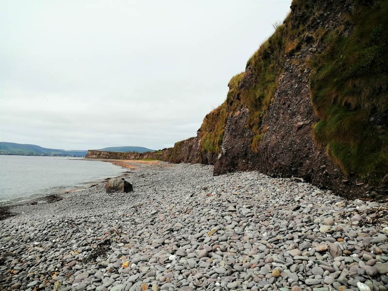
5. Geology
The cliffs that line Ballinskelligs Bay around Waterville are among the best evidence we have of the huge ice sheets that once dominated Iveragh. During the last Ice Age, glaciers travelled down from the mountains towards what we now see as Ballinskelligs Bay, carving and sculpting the landscape before them. A detour off this trail to Loher Beach gives you an excellent view of these cliffs, which on closer inspection are clearly made up of distinct units.
In some areas, the deposits appear as an unsorted jumble of pebbles, boulders, and clays. In other places, it is clearly layered and distinctly sorted by size. The finer-layered material was deposited by meltwater that flowed out from the glacier; the coarser and seemingly more chaotic material would have been deposited directly by glacial ice, rather than meltwater. The variation between these two groups suggests that the retreat of the ice sheet was not a simple process, but occurred in several cycles of melting, advancing, and stagnation.
As the Ice Age came to an end and the glaciers began to melt and retreat, the debris that had been picked up and transported by the ice was dumped to the ground forming mounds of glacial deposits. These deposits trapped and dammed glacial meltwater as it drained across the landscape forming a series of lakes in the Cummeragh Valley, of which, Lough Currane is the largest.
-

6. Whales and Dolphins
Some of Ireland’s cetaceans (whales, dolphins and porpoises) can be seen from dry land, which is excellent news for those of us that lack sea legs! A high vantage point with unobstructed views is always a good start, so this trail ticks that box at several locations. In recent times, Harbour Porpoises (Mhuc Mhara), Common Dolphins (Deilf Choiteann) and Minke Whales (Droimeiteach Beag) have all been sighted in the waters seen from this trail. Remarkably, Humpback Whales (Míol Mór Dronnach) are occasionally spotted off of Iveragh’s coastline; keep your eye on the waters and you may be one of the lucky few to catch a glimpse of these amazing creatures.
To learn more about the common species of whales and dolphins seen around Iveragh and how to identify them, visit our section on Dolphins and Whales. If you wish to submit your records to the Irish Whale and Dolphin Group’s national database, it’s a good idea to bring a pair of binoculars or scope, a camera and something to take notes on. You can submit your sightings through their online portal.
-
7. Ballinskelligs Bay SAC
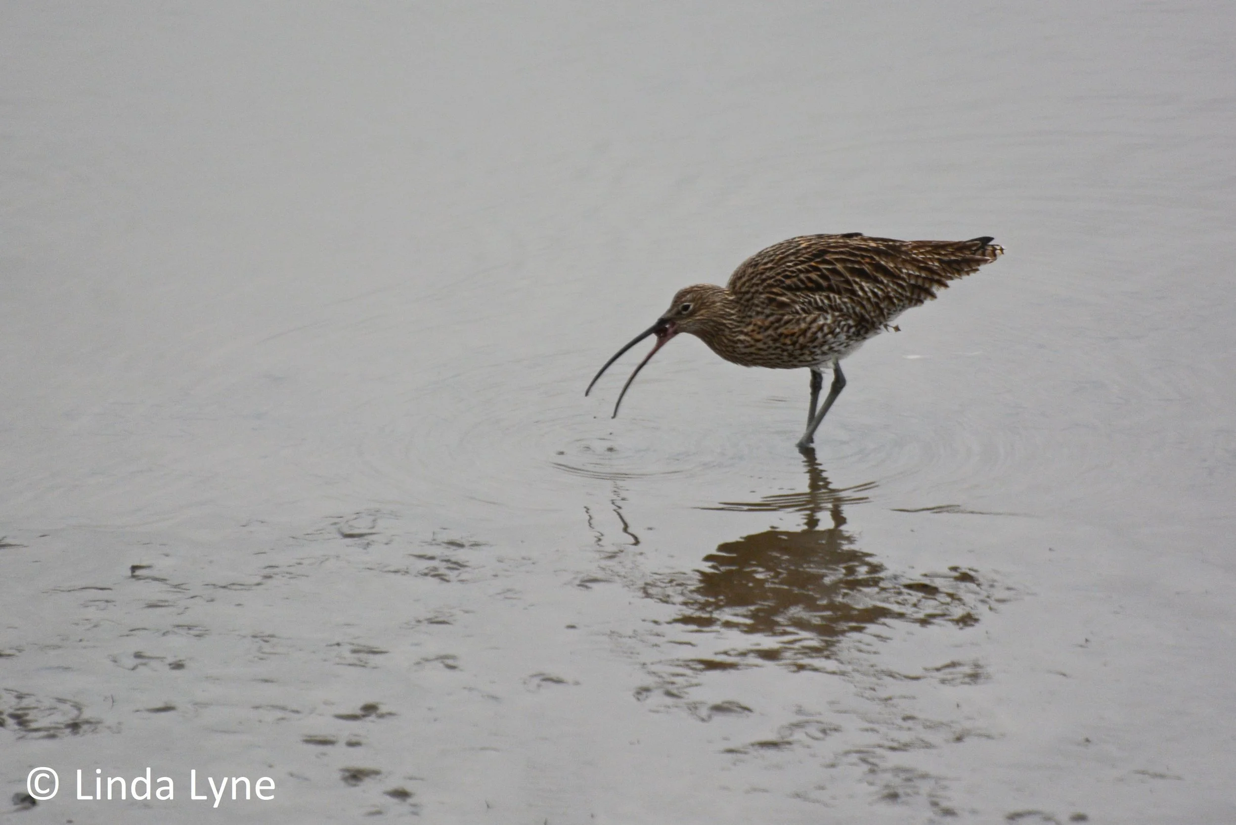
Leaving Waterville, you will have superb views across Ballinskelligs Bay and Inny Estuary which has protected status as a ‘Special Area of Conservation’ (SAC). This special status is given due to the unique Atlantic Salt Meadow and Mediterranean Salt Meadow habitats that are found there, as well as a rare species of liverwort, known as ‘Petalwort’. In addition, large numbers of wetland birds overwinter here, including Curlew (Crotach), Ringed Plover (Feadóg Chladaigh) and Oystercatchers (Roilleach). Look out for large rafts of the black sea-duck Common Scoter (Scótar) from October to March that number in the thousands; their flocks stretch like oil slicks as they surf the waves rolling into the bay. Read more about our winter wading birds in our Winter on Iveragh section.
-

8. Loher Fort
Loher Fort (Cathair an Lóthair) is an important ringfort. Excavations in the 1980s revealed the remains of two ‘dry’ stone-built houses, as well as several earlier timber or stone structures. Seven inset arrangements of opposing steps occur on the internal face of the fort’s wall. Faintly visible rock art is found on the boulder closest to the entrance.
In 1864, Bishop Charles Graves and his son, Alfred, excavated under a ‘huge cupmarked block’ believed to be the capstone of a tomb. Their report included a drawing of the rock and a description of a 7.3m long narrow passage leading to a subterranean chamber. Fragments of charcoal and charred bone were recovered. The location of this site was unknown until archaeologist Aoibheann Lambe recognised the rock in the drawing as the same cupmarked boulder located 100m downslope from Loher Fort on the summit of a low hillock. According to local lore, tunnels run between the Fort and this hillock.
The above is partly derived from the descriptive data on the Archaeological Survey of Ireland.
-
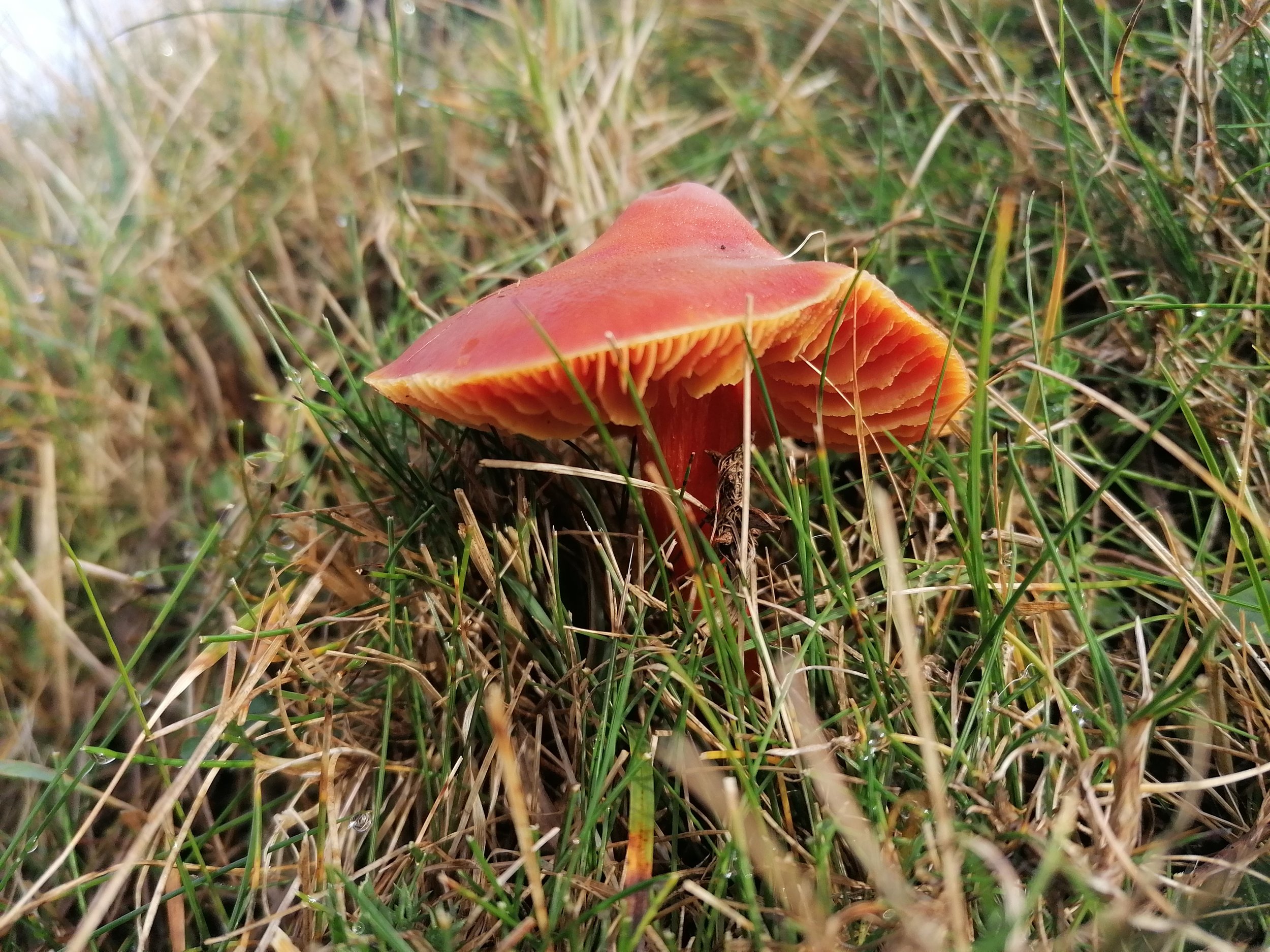
9. Waxcaps
In autumn and early winter, keep a good look out along the grasslands of the farm sections for Waxcap fungi. Coming in bright colours such as golden yellow or a rusty crimson, their glistening or waxy finish gives them their name. Waxcaps are generally found in older grasslands such as those that are not disturbed by ploughing and those that are not fertilized with artificial nutrients. The traditional sheep grazed pastures of Iveragh offer the right conditions for these fungi to grow. They are not considered edible, so they are best left to grow where you find them. Instead, perhaps you can catch their jewel-like beauty or the sun through their gills in a photo to remember your journey on this trail.
-

10. View from the top
It’s not a bad complaint when you have trouble deciding which way to look on a trail! At the highest points, this gets even more difficult as the seascapes of both Ballinskelligs and Derrynane bays are revealed. To the north, Bolus Head curves away from Waterville, via Reenroe and Ballinskelligs beaches, which leads your eye to the Skellig Islands on the horizon - you can take a closer look at this area by walking the Skellig Way. The headland reaching around the southern shore of Ballinskelligs Bay is Hog’s Head, with its Napoleonic-era lookout tower perched on top.
Turning to Derrynane Bay you will be struck by the number of islands that are found here. Starting with the furthest north (and closest to Hog’s Head), you will find the larger Scariff Island followed by Deenish closer to shore. Beyond Derrynane beach, in the far left of the photo you will see the headland known as Lamb’s Head, with the larger Beara Peninsula visible in the distance on a clear day. Abbey Island is the larger island in the foreground, connected to Derrynane Beach via a ‘tombolo’ (a sandspit connecting an island to the mainland). Lamb’s Island is the smaller island in the foreground, slightly to the right of Abbey Island. Finally, the aptly named ‘Two-Headed Island’ is situated behind Abbey Island just off the tip of Lamb’s Head. With such a spectacular coastal landscape, why not take to the water for a closer look with one of the many boat tour operators.
-

11. Dark Sky Reserve
Thanks to its remote location and rural landscapes, Iveragh is home to some of the darkest night skies in Europe. This fact was officially recognised in 2014 when the ‘Kerry International Dark-Sky Reserve’ on Iveragh was awarded Gold Tier status by the International Dark-Sky Association. Stretching from Kells Bay to Castlecove, locations outside of urban centres reveal the wonders of astronomy in glorious detail. Pack a flask of tea, find a cosy spot, lay back and gaze at our Milky Way, or take in a celestial event such as the annual ‘Geminids meteor shower’ in December. In our Dark Skies section, you will find more information on the Kerry International Dark Sky Reserve, Iveragh’s nocturnal animals and even archeoastronomy (where the worlds of archaeology and astronomy intertwine)!
-

12. Derrynane Mass Loop
We are very fortunate on Iveragh to have access to a wonderful web of interconnecting walkways taking us from the seashores to the uplands and all of the habitats in between. With the gracious permission of landowners, we can ramble to our hearts content all year round. The trail from Waterville to Caherdaniel via the Coastal Route joins the Derrynane Mass Path for a section that includes a wander through native woodland. The Mass Path traverses an ancient route that has been used by countless generations. We have gathered a wealth of information on the Derrynane Mass Path to help you explore this beautiful area of Iveragh.
-

13. Derrynane Woods
Native woodlands are rare these days, so when you get a chance to explore an area as beautiful as Derrynane Woods it is a real treat for the senses. The autumnal canopy of golden and russet hues, the crunch of leaves under foot, the smell of the soil after rain or the taste of a freshly fallen hazelnut are just some of the joys a woodland can bring. Whether it’s to stop and feel the bark of a tree, inhale the aroma of wild garlic, or immerse yourself in the sounds of the dawn chorus, woodlands have a wonderful way of helping us slow down from the fast pace of life and recharge the mind. Embrace it.
-

14. Ringforts
Two ringforts, separated by a stream, are located on the southern slopes of Cahernageeha mountain, below the road. The larger, more imposing ringfort, on the left lends its name to the nearest village (Caherdaniel/Cathair Dónall) which was originally located here, but now lies half a kilometre to the east. The ringfort is built on a rocky outcrop which falls steeply away from the northern section of the site, where the enclosing walls survive to a maximum height of five metres. Several upright slabs and traces of dry stone facing occur in the northwest quadrant of the ringfort’s interior and may represent the foundations of a hut. In the southwest section of the ringfort, the entrance passage to the ringfort is blocked off but it originally measured 5m in length and 2.5m in width. The walls of the smaller ringfort are severely denuded, its interior is filled with rubble, loose stones and small irregularly shaped mounds.
-

15. Caherdaniel Village
This section of the Kerry Way ends in Caherdaniel village. A small gathering of buildings and homes at a crossroads, it offers a peaceful spot to relax or enjoy a hard-earned meal. It is the gateway to Derrynane National Historic Park where you’ll find one of the most beautiful beaches in all of Iveragh. There is lots to do here: seaweed tours, watersports and a range of activities centred around wildlife or astronomy. And, of course, countless hours can be spent around Derrynane House and Gardens with the neighbouring woodlands and trails.