
Whitestrand and Bealtra Geotrail
LOCATION: ‘Over the Water’, Cahersiveen
LENGTH: 4.5km
DIFFICULTY: Easy to Moderate
PARKING: Whitestrand Car Park
A little bit about the trail
The route is easy going and covers a distance of roughly 4.5km. The trail is best completed at low tide. The trail mostly crosses sandy beach but scrambles over rough and uneven rock surfaces may be required to examine some outcrops. Beware of slippery rocks and take great care near unconsolidated glacial cliffs. The walk is an out and back style, although some retracing is required as the Whitestrand car park serves as the Start/Finish Point. There are no waymarkers for this route. Part of the fun is hunting for each of the geologic features!
HOW TO EXPERIENCE THE MAPS:
The map locations can be seen on your mobile device. Clicking on the square icon in the top right hand corner of the respective map to open the map in a web browser or Google maps app. Or you can click on the square in the top left of the map to follow it on this page.
TRAIL GUIDE:
Below the maps is the guide for the map and the selected points.
There is also an alternative Storymap:
Whitestrand and Bealtra Geotrail
We want to share our beautiful corner of the world with you and with many generations to come. For this reason, we support regenerative, sustainable and responsible ecotourism and we hope you will too. Please take a minute to read our 'Things To Know Before You Go' so you can also play your part. Go raibh maith agat.
Geologic background
Most of the area around Whitestrand and Bealtra is part of a large strip of Devonian Old Red Sandstone, known as the Valentia Slate Formation. The Valentia Slate Formation has been assigned an age of around 385 million years, based on the dating of nearby ash layers. These ash deposits are located at Keel, in the Glen and at Enagh Point on Doulus Head, just northwest of Bealtra. The presence of these volcanic ash deposits, known as tuff, provides clear evidence that sedimentary rocks were not the only rock type forming at the time. As the sediments were being deposited, the continental crust was pulling apart and stretching. As the crust stretched, faults and fractures developed through the layers of rock. These fractures provided routes for magma from deep inside the earth to rise towards the surface. Some of this magma burst to the surface as violent volcanic eruptions that formed billowing ash clouds. However, other portions of the magma remained below the surface and spread out between the layers of sandstones and siltstones.
The area around Beginish Island and Whitestrand was at the centre of much of the volcanic activity on the Iveragh Peninsula. At Beginish Island a large intrusion of an igneous rock called dolerite is exposed at the surface. Dolerite is the coarse-grained equivalent of basalt and has the same mineral composition. This dolerite formed as a sill. Sills form when hot molten magma is injected into existing horizontal rock layers, where it cools and solidifies. The igneous intrusion at Beginish travelled through the rock layers, over to Whitestrand and Bealtra Bay. Here the intrusion appears to have split into two layers that intruded into rocks at different depths. The dolerite at Laght Point is the lower section of this unit and was emplaced into fully cemented (lithified) sedimentary rock. The shallower sill at Bealtra was emplaced into uncemented sediments and broke to the surface to create a jumbled and colourful rock mass that is among the most interesting geologic features on the peninsula.
Follow the map below to find out more about the mark this incredible event left in the rock record and learn about other evidence of earth processes preserved along the trail.
-

1. Laght Point Dolerite
The dolerite igneous intrusion here shows little disturbance at its contact with the sandstones and siltstones. This indicates that these rocks had already solidified when the sill was emplaced. The dolerite has a porphyritic texture, which means that larger crystals sit in a matrix of finer grained material. This kind of texture forms when the big crystals cool slowly but the rest of the cooling happens quite quickly and so forms smaller crystals. The rate of cooling controls the size of mineral crystals, the slower the cooling the larger the crystals.
As the extremely hot molten rock intruded into the existing rock layers, it heated up the surrounding rock. This changed the mineral structures in the rocks around the dolerite through metamorphism. The sill also shows chilled margins. Chilled margins are fine-grained areas along the outside of the intrusion where the magma came into contact with the cold host rock and cooled rapidly.
The sill is recognisable as a wall of smooth and crystalline green-blue rock, in contrast to the surrounding rough and grainy Old Red Sandstones. However, the dolerite has weathered to a dark brown in places.
-

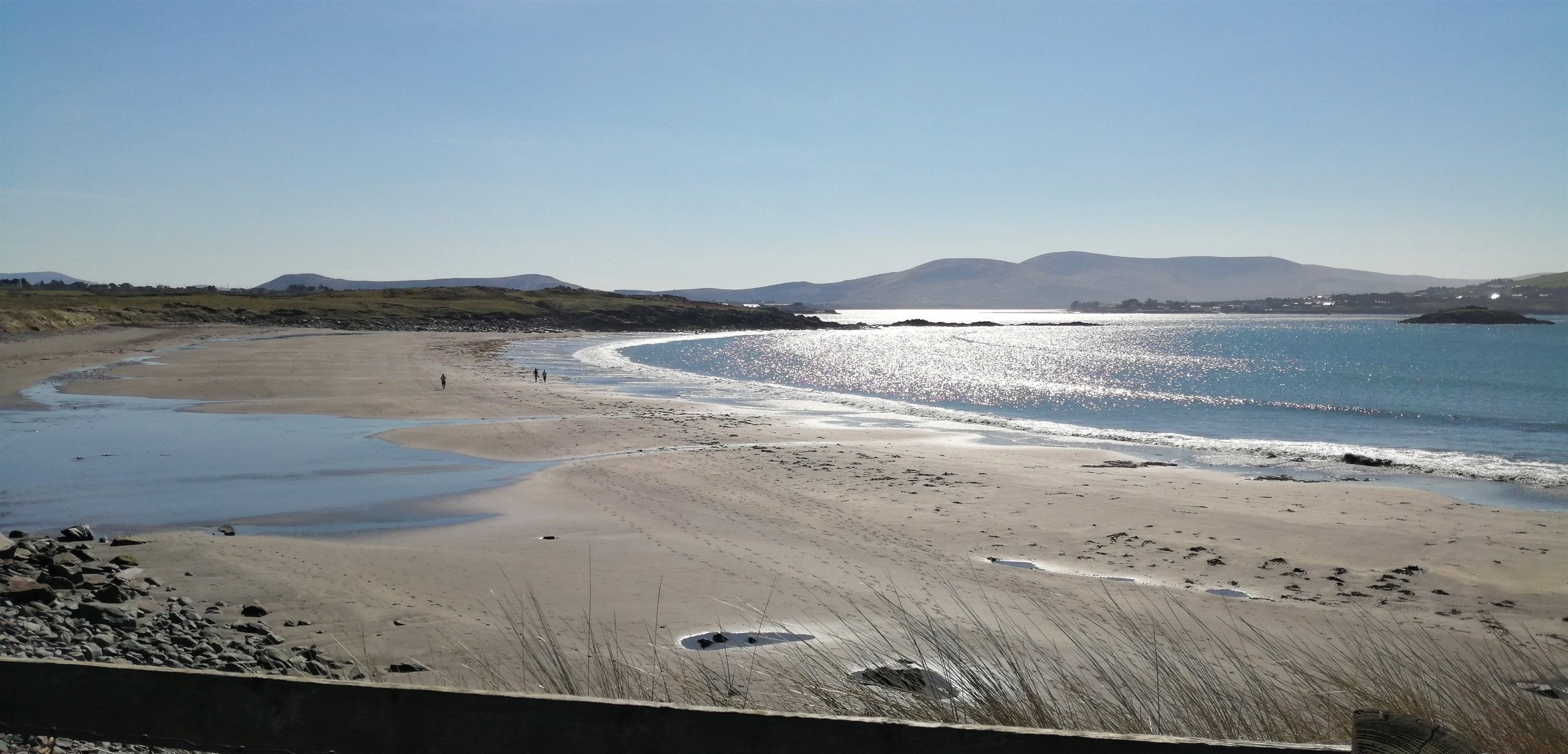
2. Whitestrand Beach
The presence of the dolerite sill exerts a control on the existence of the small headlands and bays at Whitestrand and the adjacent Bealtra. Varying erosion rates often occur due to the presence of different rock types. Igneous rocks tend to be harder and more resistant to erosion, while sedimentary rocks are usually softer so erode and weather more readily. At Laght Point and Bealtra Bay the hard bands of dolerite protrude as small headlands, while the softer Valentia Slate has worn away to form the bays. These headlands shelter the bays from the brunt of strong wave action. Under these low energy conditions, waves and tides tend to deposit material and so sand has accumulated to form beaches.
Ripple marks are often be seen along the sandy shore of Whitestrand. These serve as excellent analogues for the ripple marks that are frequently observed in the Old Red Sandstone rocks. Ripple marks are sedimentary features that form through the deposition and transport of sediment by currents of flowing wind or water. While the ripple marks preserved in the Old Red Sandstones were formed by water flowing in river channels rather than along the seashore, the similarity is remarkable. The presence of these features at Whitestrand highlights their transience and is a reminder of how incredible it is that we can see similar features preserved in the rocks after 385 million years!
3. View of Beginish Island
Beginish or ‘Beiginis’ in Irish which translates as ‘Little Island’ is situated to the west of Whitestrand. Although small, this island hosts the largest exposure of igneous rocks on the Iveragh Peninsula, making it a key piece in the geologic puzzle. Beginish Island is also of huge cultural significance, as it contains archaeological evidence of Viking settlement between the 9th and 12th centuries.
At Beginish Island the dolerite intrusion shows columnar jointing. The columnar jointing forms pillars like those found at the Giant’s Causeway, although amazingly the columns at Beginish are over 300 million years older. These columns form during the cooling of pools of molten rock material. The molten rock cools quickly at the contact with the colder host rock. As the magma cools, it contracts, and fractures and cracks develop. These cooling fronts and fractures extend through the magma pool and the intersection of the fractures creates the regular array of polygonal columns.
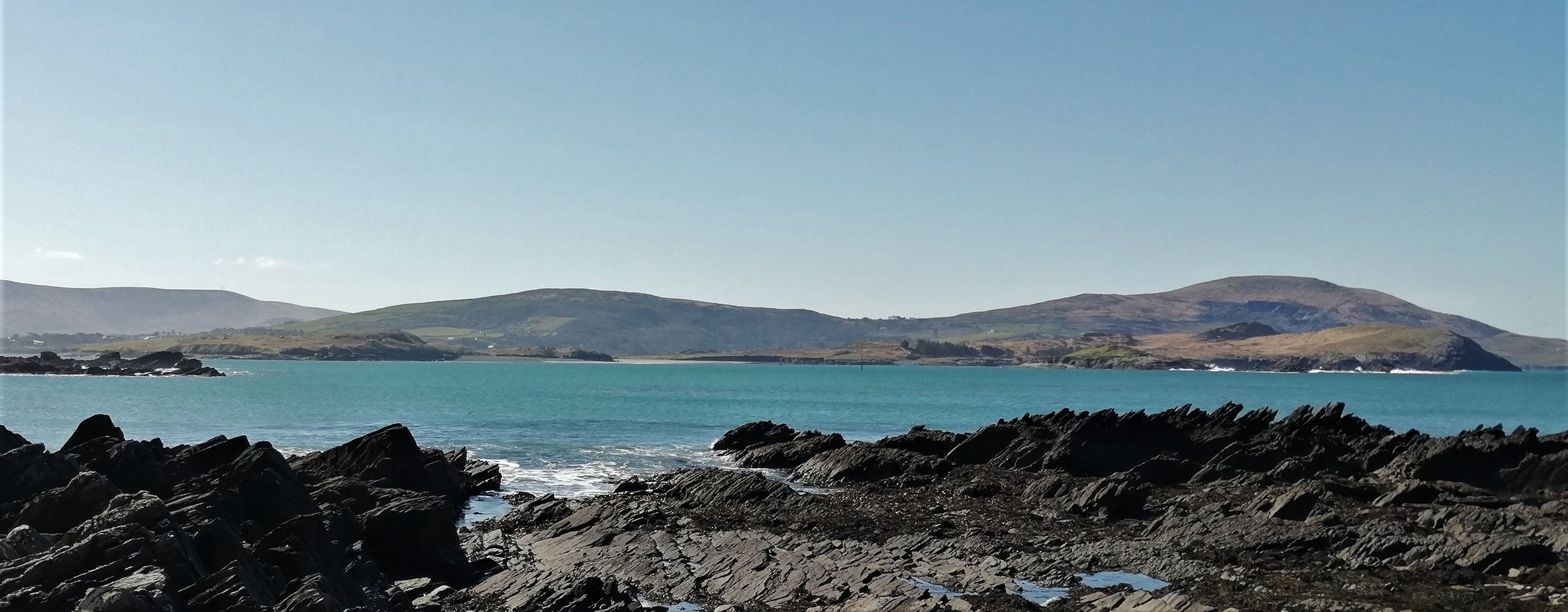
A tombolo, which is a bridge of sand connecting two land masses, extends from Beginish towards the smaller Church Island. This sand bridge formed because the waves rolling in from the Atlantic approach Beginish Island at an angle rather than head on. On such coastlines, sand and beach sediments are transported by longshore drift. In longshore drift, the sediment is pushed onto the beaches at an angle of about 45 degrees by the swash. The backwash then drags the material straight back out towards the sea at right angles to the coast. Through this process material is transported in a zig-zag pattern across the shore. When the coast changes direction this process continues, and material is deposited as a thin strip extending out from the coastline. Where this sand spit meets an island, a tombolo is formed.
-
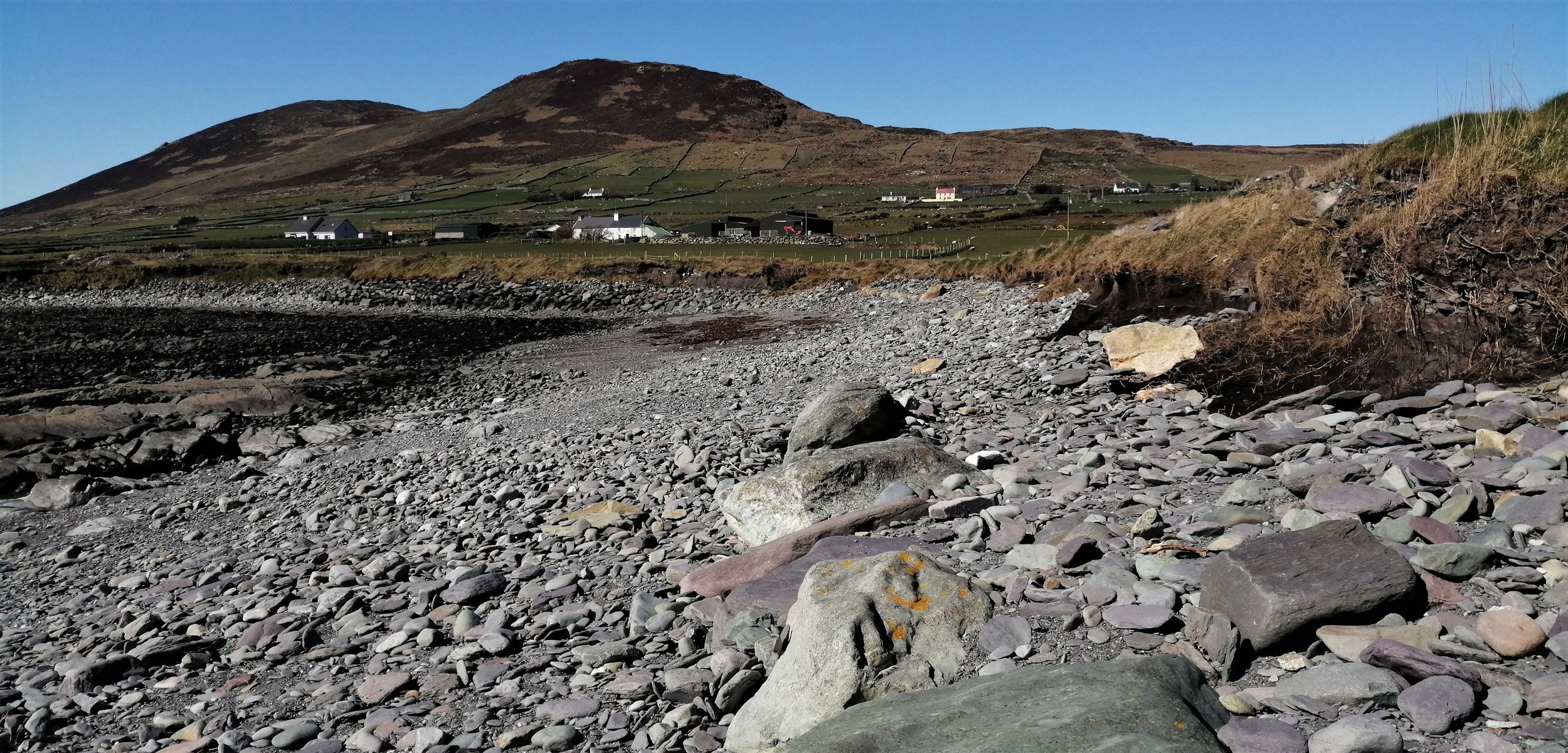
4. Glacial Deposits
Before leaving Whitestrand, notice the cliff of mud, sand, pebbles, and boulders, that backs the northern end of the beach. These sediments were deposited by ice. The last Ice Age was at its maximum extent about 25,000 to 20,000 years ago, and at the time almost all of Ireland was buried beneath massive ice sheets. These ice sheets crept slowly across the landscape and were often hundreds of metres thick. The ice sheets had largely retreated from lowland areas by around 14,000 years ago, but not before they ravaged and sculpted the landscape, collecting vast quantities of mud, pebbles, and boulders in the process. When the ice sheets melted, this debris was dumped and left behind to form the thick deposits seen here.
Close examination of this cliff will reveal that the sorting and arrangement of material is not uniform throughout. In some places it is unstratified and unsorted, which suggests that it was deposited directly by glacial ice, while in other places it is clearly layered and sorted, indicating deposition by flowing meltwater.
These glacial deposits are exposed intermittently along the Iveragh coastline. Since these deposits are unconsolidated, they are highly susceptible to erosion by powerful waves and can vanish quite rapidly, causing sudden changes in the appearance of the coastline.
-

5. Magma Sediment Mixing
At Bealtra Strand, the dolerite sill intruded into wet and unconsolidated sediments close to the surface. As the magma approached the surface there was a reduction in pressure which caused the magma to expand and bubbles of gas to be driven out of the magma. The small holes seen in some areas of the rock, called vesicles, were left behind by gasses escaping the magma. At the same time, the hot magma came into contact with the wet sediments and large volumes of steam were produced. The combination of these two factors resulted in an explosive disruption at the top of the intrusion.
At this point you are located near top of the sill. Here the dolerite was intensely broken up and mixed with the highly disturbed wet sediments. The resulting rock shows considerable alteration of the original dolerite and is composed of a mixture of large clasts, up to 20cm, embedded in a fine-grained mineral matrix. These clasts are dominatingly dolerite, pyroclastic material and a green rock called epidosite.
Pyroclastic material is ejected into the air from explosive volcanic eruptions as fragments of rock and ash, that cool quickly. The pyroclastic material in this rock is mostly fragments of basalt and scoria. Scoria is an igneous rock made that has many bubble-like vesicles and appears red here.
Epidosite is a metamorphic rock which is mainly composed of a green mineral called epidote and quartz. Epidosite formed when parts of the magma were transformed and altered in contact with the hot fluids.

6. Beach Sediments
While this large expanse of sand may seem of little interest to geologists, sand is made up of tiny fragments of rock and minerals and so begins its story as part of a larger rock. While rocks may seem permanent, they are constantly eroded and broken down by the relentless action of the wind, rain, and waves. Over many millions of years even the strongest rocks will be broken down into tiny sand sized particles. Sand is part of the endless churning of the rock cycle that has shaped the earth surface over the last 4.5 billion years and will continue long into the future.
Sand is made up of a variety of materials and the colour of the sand reflects its composition. The most common component of the sand at Whitestrand and Bealtra is the mineral quartz. Quartz gives the sand its white colour. The sand also has some amount of ground up shells and other skeletal remains and interesting remains of modern crabs and shells can often be found along the beach.
The back of the beach is lined with pebbles, many of which contain fragments of volcanic rock and evidence of magma sediment mixing. These pebbles were thrown to the back of the beach during ferocious storm events.
-

7. Rock layers
During the Devonian, sediments were deposited in horizontal layers. Layers of rock with uniform sediment compositions, textures, and colours, are known as beds and represent different depositional events, for example individual floods or changes in the sediment supply of rivers. Here the beds have been overturned by about 90 degrees from their original horizontal positions. The contacts between the layers represents a ground surface that was once exposed at the top of the sediment pile, during a period when no deposition took place and may account for timescales spanning from years to centuries.
The rock layers were overturned during the Variscan Mountain building event. The Variscan mountain building event occurred about 300 million years ago, when Iveragh got caught up in tectonic plate collision. The immense pressure and compression created as the two tectonic plates were pushed together resulted in the rock layers being buckled, crumbled, and uplifted to form the Macguillycuddy Reeks and the other mountains of Iveragh.
-

8. North Bealtra Dolerite
The section of the dolerite sill exposed here is very different to that found at Whitestrand. Here the dolerite is very fine grained but looking closely at the freshly broken rock surface the rock is clearly made up of a mass of tiny crystals. The small crystal size suggests that the hot molten rock cooled much quicker than that found at Whitestrand. The darker crystals are composed of the mineral pyroxene, while the lighter crystals are feldspars. Feldspars are the most common rock forming mineral on Earth. Pyroxenes are very important and abundant in igneous rocks, such as dolerite.

9. Volcaniclastic Breccia
When the dolerite sill at Bealtra broke to the surface, the magma was disintegrated and mingled with the poorly consolidated wet sediments, as well as ash from nearby volcanic eruptions. As a result, the rocks here are fascinating mixture of colours, shapes and textures and are known as volcanic breccia.
This rock does not show any layering and has an unsystematic variation in clast shape, size, and type. The most common clasts are purple siltstones, fragments of the dolerite sill, and other volcanic rocks such as basalt and andesite. The purple siltstones show clear signs of having been deformed while still wet and often have tapered ends and swirling patterns. The clasts are set in a matrix of ashy siltstone. Here many of the vesicles have been infilled with minerals such as chlorite and calcite. Vesicles with mineral infillings are known as amygdales.
Moving westwards the frequency of larger clasts in the volcaniclastic breccia is reduced and the rock becomes dominated by finer grained material.