
Derrynane Loop Walking Trail
LOCATION: Caherdaniel
LENGTH: 7km
DIFFICULTY: Moderate
PARKING: Derrynane Carpark
A little bit about the trail
Our map does not correspond to exact points or numbered signs along the trail. Instead, this map is seen as a companion for the area, filling you with information on what you might find and where you might find it. It will hopefully add to your enjoyment of this wonderful corner of Iveragh and help build the memories that will stay with you long after you leave.
The start and end point of the trail is the car park at Derrynane House (point #1). When you are ready to set off, walk east and then turn off to the right for the Seashore Nature Trail (point #2); alternatively, you can pass through the metal gate in the southwest corner of the carpark, head towards the dunes and follow the mown grass path (point #3). From point #3 on our map, you will be looking for the way-markers with a yellow arrow and walker. We recommend comfortable hiking boots, rain gear, water and snacks. Most of all, don't forget your sense of adventure and to leave no trace! As this trail passes through sections of farmland with livestock, dogs are not permitted.
In addition, this fascinating podcast from Frank Lewis for Radio Kerry is an excellent insight into the culture, history, flora and fauna of the route with wonderful input from a range of knowledgeable Derrynane locals.
HOW TO EXPERIENCE THE MAPS:
The map locations can be seen on your mobile device. Clicking on the square icon in the top right hand corner of the respective map to open the map in a web browser or Google maps app. Or you can click on the square in the top left of the map to follow it on this page.
TRAIL GUIDE:
Below the maps is the guide for the map and the selected points.
There is also an alternative Storymap:
Derrynane Mass Loop
-

1. Derrynane House Carpark - Start/Finish
Ample parking and toilet facilities makes the carpark at Derrynane House an ideal start and end point for the Mass Loop. Derrynane House was the ancestral home of Daniel O'Connell and is now a museum. A tour of the museum tells the history of O'Connell while moving between the rooms of the house, which are preserved with furnishing from that era. The ornate gardens include a fairy forest, archaeological sites, and a wide range of ornamental plants. Refreshments are also available on site and will be especially welcome at the end of your trail!
-

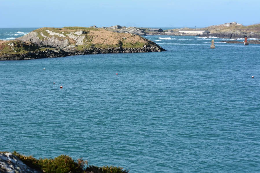
2 - Derrynane Seashore Nature Trail & Wild Derrynane Nature Tours
A slight diversion from the Mass Loop, the Derrynane Seashore Trail is worth the detour or maybe dedicate a whole day to it on another visit. Numbered OPW information points corresponding to stunning visual media through a fantastic app which you can download here. From Birds, to Pollinators and Wildflowers there is lots to learn for all ages. It's just one of the many ways to immerse yourself into the region through a host of options available via Wild Derrynane Nature Tours - helmed by environmentalist and multimedia artist Vincent Hyland. From guided walks or diving trips to rockpool ID fun or educational tools - they provide endless ways to explore the landscape.
-
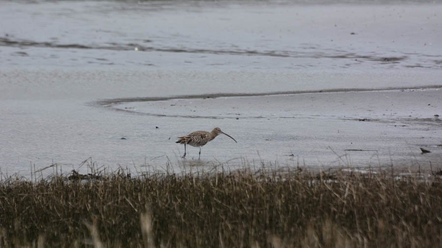
3 - Wading Birds
The lagoon at Derrynane is a great spot to look and listen for wading birds. The numbers of species are higher from October-March, when visitors arrive from northern areas to overwinter in our milder climate. Look out for Curlew (Crotach), Little Egret (Éigrit Bheag) and Ringed Plover (Feadóg Chladaigh) to name just a few. While you might see many Curlew in winter, these are birds that have migrated here from colder northern countries. However, if you see or hear curlew in summer there is a good chance that they are the highly endangered Irish breeding Curlew. The species is in rapid decline in Ireland but people such as the Curlew Conservation Plan are working hard to increase their numbers. LIVE has created some wonderful educational resources based on the curlew - check them out here .
-

4. Natterjack Toads
A very rare and endangered species in Ireland, the Natterjack Toad (Cnádán) can be found around the ponds of the sand dunes at Derrynane. A protected species, the natterjack population has a helping hand from local landowners and staff at National Parks & Wildlife Service through a conservation program in the region. As a burrowing species, the dunes are the perfect habitat for them, and you might just hear their mating calls during Spring on Iveragh! You may also observe Common Frogs (Frog) in the pond areas and there are a number of features to help tell them apart: natterjacks have a yellow stripe down their spine, move via 'walking' and their spawn is found in single strings. Frogs, on the other hand, move via hopping and their spawn is found in clumps.
-

5. Common Lizard
The Common Lizard (Earc Luachra) is Ireland's only native terrestrial reptile and they have been sighted in a number of spots around Derrynane. The sand dunes are one area where they might be seen, either basking in a sunny spot to warm up, or moving through the Marram Grass (Muiríneach) in search of a tasty invertebrate snack. If you have time for a diversion, the trail on Abbey Island is another area worth checking out for these extraordinary animals. You can learn lots more about our lizards here.
-

6. Red-billed Chough
Derrynane is an excellent spot for the Red-billed Chough (Cág Cosdearg) and often hosts large flocks in autumn. As the Irish name suggests, they are a corvid species similar to Jackdaws (Cág) but with bright red legs and a long curved red bill. You will often hear their 'keeaww' call before you see them, as they call to one another while probing the ground for worms and other prey items. They are often spotted around the dunes or grassy areas along this section of the trail. County Kerry hosts roughly a third of Irish choughs, so the Iveragh Peninsula is one of the best places in Ireland to see them. For more information on this coastal crow, visit our section on the Red-billed Chough.
-
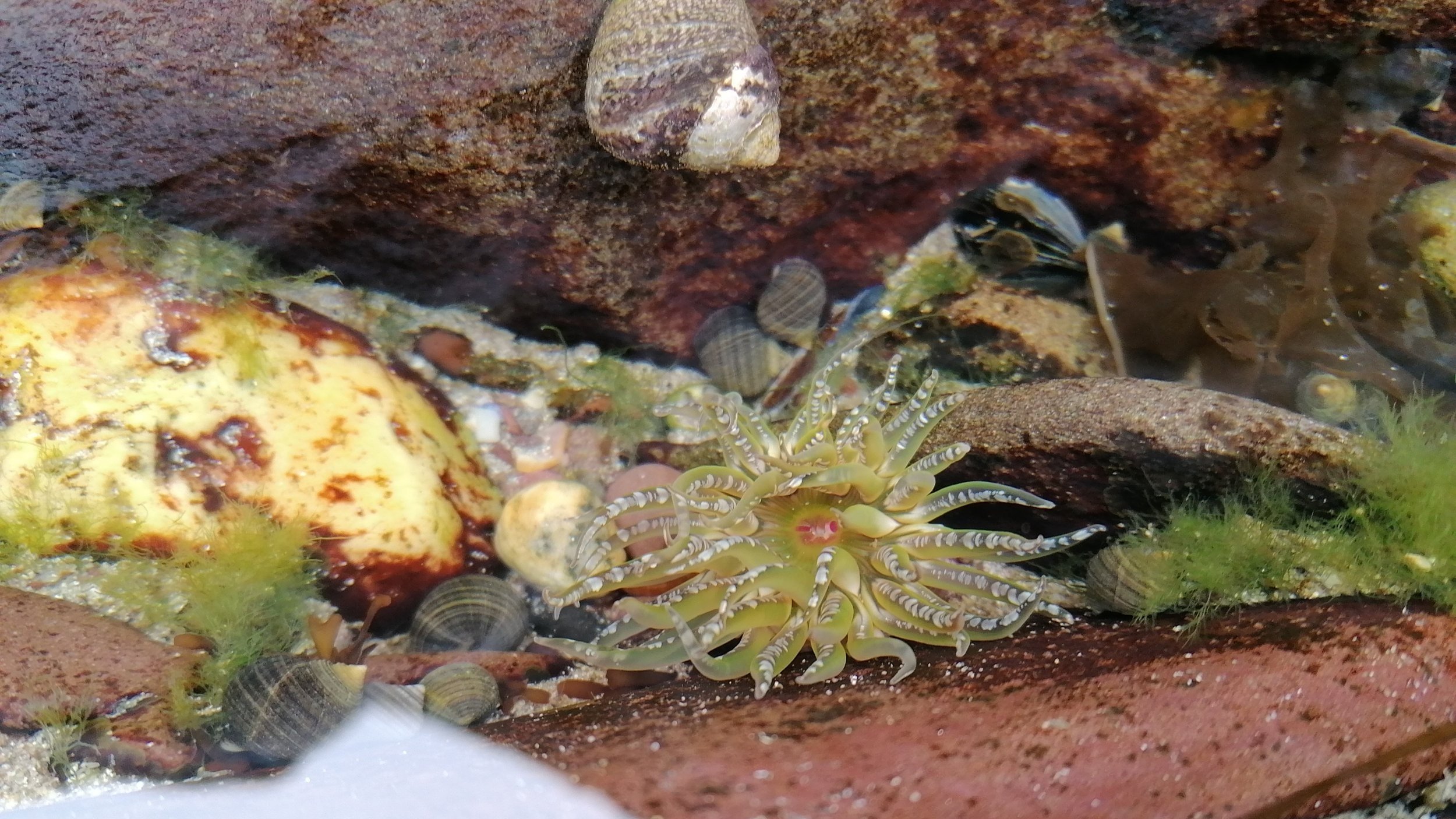
7. Rockpools
At low tide, wonderful rockpools are uncovered all around Derrynane's shoreline. Peep under some seaweed to search for Crabs (Portán) or arrive armed with a magnifying glass to peer into the detail of the life of a Barnacle (Giuránn) encrusted rock. Sea Anemones (Bundún) of brilliant colours can be found and tiny Prawns (Cliocheán) dart for cover. A great activity all year round. Ireland's Seashore: A Field Guide is a great companion book to help unlock some of the hidden treasures to be found. Please remember to look but don't touch or take to help protect these beautiful mini worlds.
-
8. Water Sports
If you have time to spare before (or after if you still have the energy!) your walk, this area of Derrynane has calm, sheltered waters, which makes it ideal for water sports, such as kayaking, stand-up paddle boarding or sailing. These water-based activities can be booked with local businesses.
-

9. From Beach to Trail
At this point the trail leaves the beach and follows a coastal section. The yellow arrow way-markers can be found pointing to a gap in the stone wall adjacent to the road next to the carpark. You will pass the Derrynane Inshore Rescue CRBI base, an essential local lifesaving voluntary service. You'll also notice some Pernettya shrubs on this section. Originally from South America, this evergreen shrub has pink berries and was planted along part of the mass path by the Earl of Dunraven's wife, Nancy, who had a house at nearby Iskeroon.
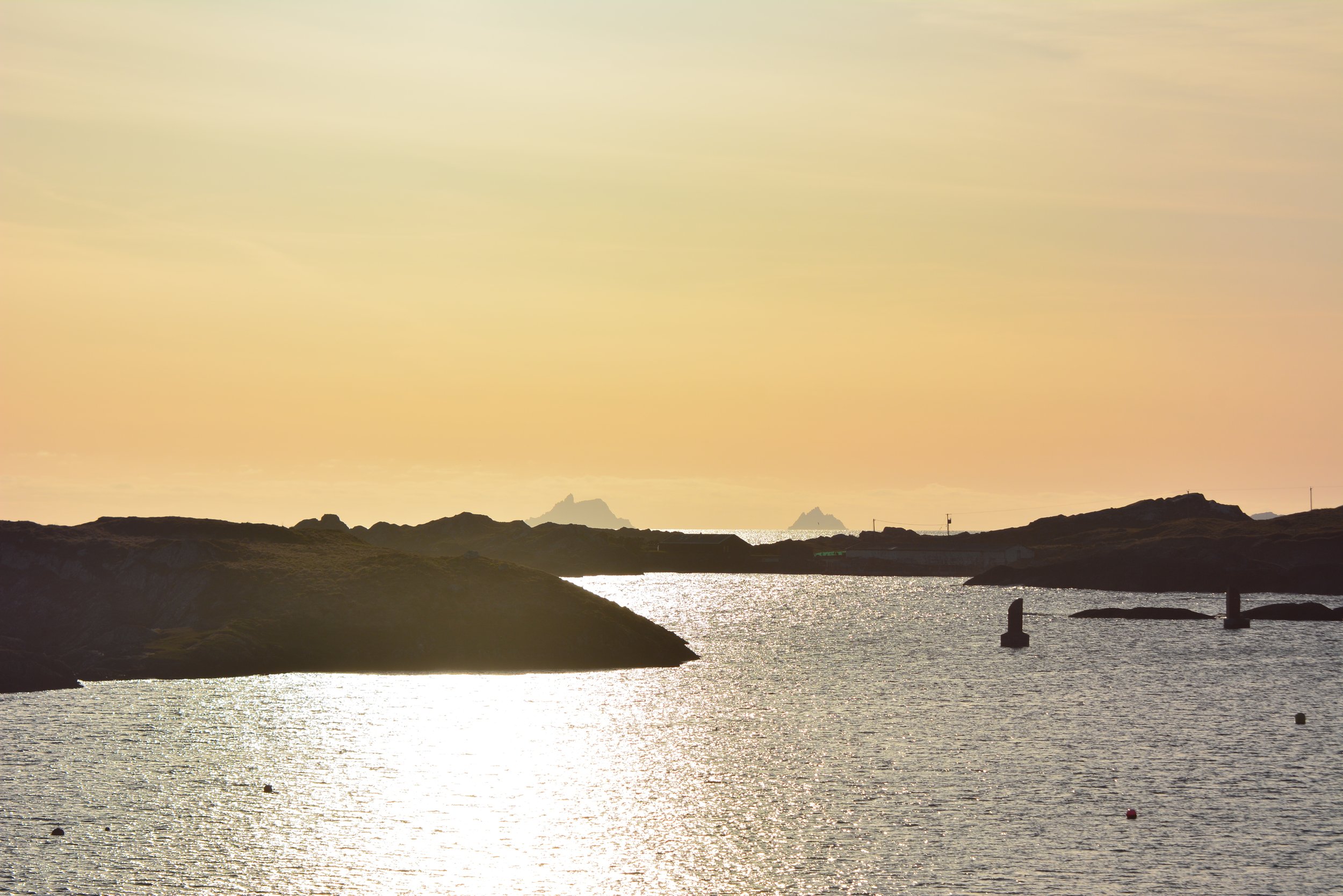
10. Coastal Path
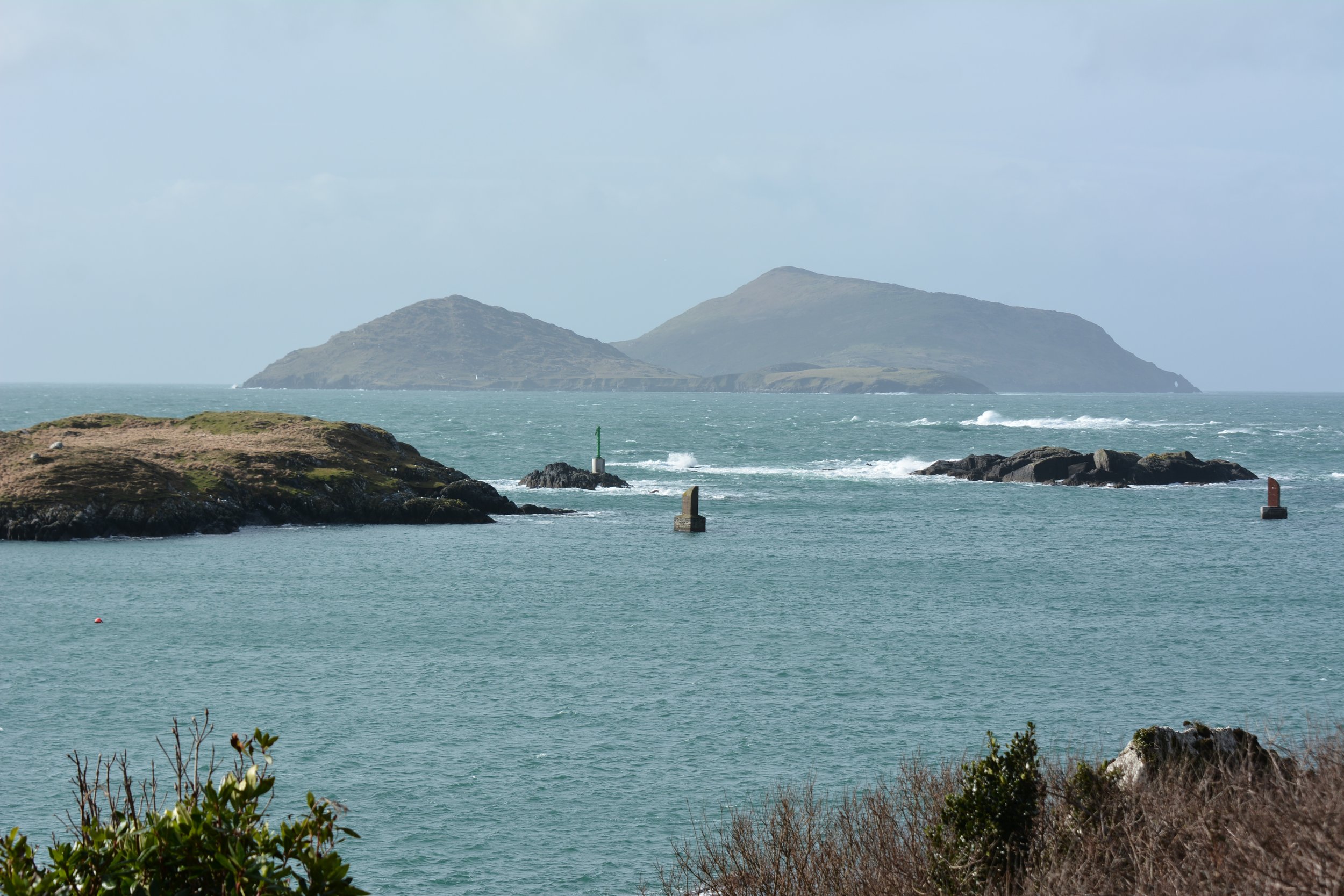
There's a lot to keep an eye out for along this section of the trail, including friendly Robins (Spideog). Looking west to the horizon, on a clear day the ghostly shapes of the Skelligs are visible. Take time to admire the views of the bay below and the wilder seas beyond. Scarriff, Deenish, Moylaun and Two Headed are some of the islands in the area, and they are home to many nesting seabirds in the summer months. There is a wealth of history to be learned and a boat trip is a wonderful way to experience this side of Derrynane. Keep your eyes peeled for birds such as Kestrels (Pocaire Gaoithe) or Peregrine Falcons (Fabhcún Gorm) which patrol the coast at almost eye-level to the trail. This is also a good spot to look for Otters (Madra Uisce), Seals (Rón) or even the occasional Dolphin (Deilf). The trail itself is also something to behold with many steps hewn from the rocky surface.
-

11. Beachcombing Cove
This little cove is a beautiful spot and an ideal rest stop. Listen to the waves roll in and out, hear the birdsong from the adjacent woods or watch for diving birds such as Great Northern Divers (Lóma Mór). This cove is also a great spot for a bit of beachcombing. Colourful shells, Mermaid's Purses - which are actually egg cases from species such as Sharks (Siorc) and Rays (Roc) - and all sorts of other items wash up here. Seaweeds (Feamainn) in all shapes and colours gather here so it's a great spot to see how many you can find. In fact, you can book seaweed walks at Derrynane to hone your foraging skills or recipe ideas.
Also, when leaving this area keep an eye open for ripple marks on the rocks. Point #18 on the map will reveal more....
-

12. Flora & Pollinators
Large swathes of Heather (Fraoch) and Gorse (Aiteann) are found along the trail, and these plants are a vital source of nectar for many of our Pollinators (Pailneoirí). The vibrant yellow flowers of gorse bloom almost year-round but gain a luscious coconut aroma and an additional burst of life in early spring. Bees (Beach), Hoverflies and Butterflies (Féileacáin) flock to both gorse and heather and the whole bush can hum with the collective buzzing of these vital workers. You should also be vigilant for more rare flora sightings such as the Kerry Lily (Lile Fhíonáin) or Orchids (Magairlín). You may also see what at first appears to be a tiny Hummingbird, but on closer inspection is revealed to be the spectacular Hummingbird Hawk Moth (Dordéan Conach), hovering from flower to flower to refuel after migrating from mainland Europe.
-

13. Bealtra Beach
A tantalising glimpse of the Skellig Islands from earlier in the trail may have whet your appetite for a boat trip. Passing some of the bird rich islands en route, these tours are also an ideal opportunity for some dolphin watching before arriving at the world-famous UNESCO World Heritage Site. Booking in advance is essential due to strict control in numbers permitted to operate on and around the islands. If you're not feeling the force, you can always opt for a snack break in this once busy fishing hub of the region. From this point on the trail, the uphill section will begin so you might need that energy boost.

-
14. Farmland
There is a long history of farming on Iveragh, from the coastal hills to the higher uplands. In the past, the native Kerry Cow (Bó Chiarraí) and the Scottish Blackface Sheep were the most common breeds. The smaller Kerry Cow was better suited to the boggy terrain and would eat rougher vegetation such as Bracken (Raithneach) or Gorse (Aiteann). The Blackface Sheep is a mountain specialist but has now been mixed with other breeds that produce larger weights for higher market value. Many of Iveragh's walking trails began as market routes for trading butter, wool or other goods. Farm animals were also moved along some of these trails in a seasonal grazing tradition known as 'booleying'. The animals would spend their summers grazing on the upland areas before being herded down to lower lands for the harsher winter periods. Visit our section on farmland for more information on the wildlife you can expect to encounter in Iveragh’s farming landscape.
Also, when leaving this area keep an eye open for ripple marks on the rocks. Point #18 on the map will reveal more....
-

15. Stone Walls
Ireland has over 400,000km of dry stone walls and 210,000km of stone-earth banks. Often of ancient origins, these boundaries crisscross Iveragh, sometimes on the steepest hillsides or perilously close to cliff edges. Enclosing fields or following roadways, these banks and walls are important miniature ecosystems for flora and fauna. South-facing banks are prime real estate for sun loving Common Lizards (Earc Luachra) - don't forget to log any sightings here - while tiny mammals such as Pygmy Shrews (Dallóg Fraoigh) make homes in cracks and crevices. Bumblebees (Bumbóg) utilise holes in these habitats and a host of critters such as Spiders (Damhán Alla) can be found weaving webs between gaps. Mosses (Caonach) and Lichens (Léicean) drape over many surfaces while Ferns (Raithneach) occur in an abundance of varieties. It may also be where you find your first spring Wildflowers (Bláth Fuáin) such as Lesser Celandine (Grán Arcáin) or Caterpillars (Bolb) munching on vital food sources, such as Nettles (Neantóg) or Grasses (Féar). In autumn, Brambles (Dris) take over to provide a welcome Blackberry (Sméar Dubh) feast for birds and walkers alike! Many of the plants found in areas like this have medicinal purposes that date back hundreds of years.
-

16. Brief History
The name Derrynane originates from the Irish 'Doire Fhíonáin' meaning 'Oak wood of Fíonáin' - Fíonáin being the famous St Finan who founded the monastery on Abbey Island and whose name appears in many places across the Iveragh. There is a long history of settlement in the area; various discoveries have been made over the years, including the ca. 3,000-year-old 'Derrynane Horn’, a large 'souterrain' excavated near the main house (believed to have been used to hold animals), and pre-famine ruins which are still visible in the farmland around the Mass Path. The mass rock, or 'Carraig an Aifrinn', came into being due to the persecution of Irish Catholics following the introduction of the Penal Laws (1695-1750). Many locals would travel miles to these secret mass rock locations in order to attend services and mass rocks can be found scattered across the country. In more recent times, Derrynane is associated with the O'Connell family, the construction of the house (1600s), the trade routes (and smuggling too!), and of course Daniel O'Connell himself. Tours at Derrynane House provide a wealth of information on the area’s rich history.
17. The Kerry Way
The Kerry Way is a 214km walking route taking in many of the upland and coastal trails that loop around the Iveragh Peninsula. Taking up to ten days to complete the full loop, the trail can be broken down into individual sections that followed old market routes for trading goods, or mass paths such as this one at Derrynane. With the generous co-operation of landowners, many stunning corners of Iveragh have been turned into walking trails by the South Kerry Development Partnership - more information here.

-

18. Geology
The rocks around Derrynane are part of the Iveragh Old Red Sandstone and belong to the St. Finian's Sandstone Formations. They were formed some 370 million years ago when Ireland was located just south of the equator when the climate was much hotter and drier than the Iveragh of today. The purple hue suggests the rocks formed in dry conditions, while the paler green sections you may find were formed in shallow waters (note the water ripple marks in the photo above) and built up in horizontal layers over time.
Around 290 million years ago, continental plates collided and forced the land upwards to create mountains. For this reason, some of the layers now appear at various steep angles and bends. Since then, various ice-ages have shaped the land by smoothing the rocks or depositing large amounts of debris that had been collected by glaciers. Large boulders are often picked up by glaciers on the move and then left in areas where they seem out of place. These are known as 'glacial erratics' and were often used as mass rocks.
Also, when leaving this area keep an eye open for ripple marks on the rocks. Point #18 on the map will reveal more....
-

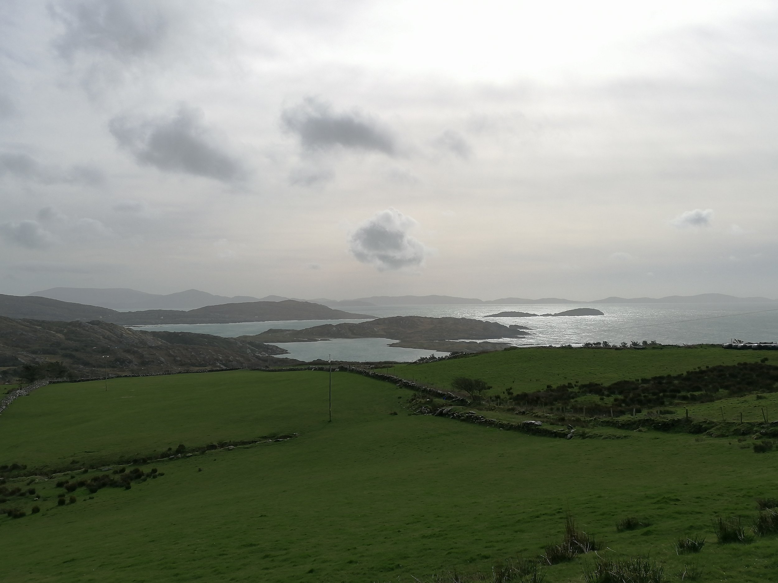
19. Highest Point
The views from the highest point on the trail are spectacular! The hillside sweeps down to Derrynane Bay which is dotted with an array of islands and headlands. Off to your far right, you may still catch a glimpse of the Skelligs beyond Hog's Head and Bolus Head further west. As you move to the left (east), you will see two islands close together; these are Scariff Island (the larger of the two) in the background, with Deenish Island in the foreground (closer to shore). These are both important breeding grounds for seabirds.
Closer to shore, you will see Lamb's Island with the larger Abbey Island to its left. Next is the appropriately named ‘Two Headed Island’ which is just off the tip of the headland, known as ‘Lamb's Head’. If you look off to the horizon to the southeast (and behind Lamb’s Head), you will see the Beara Peninsula reaching out to sea with Dursey Island at the tip. As well as the views, keep an eye out for the Common Frog (Frog) in this area. Frogspawn (Glótach Froig) can be found in some of the pools that gather on the side of the paths as early as January and right into spring.
-

20. Birds
It's possible to see and hear a host of songbirds throughout the Mass Loop trail and there are some great online aids to learning birdsong. Robins (Spideog) tend to sing year-round while spring will unveil the full choir of voices as the dawn chorus grows louder each morning. Soaring high in the air above Derrynane is the most likely place to spot birds of prey such as Buzzards (Clamhán) or, if you are very lucky, the reintroduced White-tailed Sea Eagle (Iolar Mara). September/October will see the arrival of over-wintering visitors such as the wetland birds you might see at the lagoon. However, these upland areas are where Thrush (Smólach) species such as Fieldfares (Sacán) and Redwings (Deargán Sneachta) prefer to spend their time, feasting on the berries of Rowan (Caorthann) or Holly (Cuilinn). Spring sees the arrival of yet another cast of birds as the skies become alive with the spectacular acrobatics of Swallows (Fáinleog), Swifts (Gabhlán Gaoithe) and Martins (Gabhlán). Meadow Pipits’ (Riabhóg Mhóna) emphatic flights begin in late February as they climb higher and higher, calling louder and louder, and then ‘parachute’ back to earth in a crescendo of calls. Wheatear (Clochrán) will also arrive in spring and it's always worth checking Kerry Birding for any other unusual species.

-

21. Choice of Trail
At this point of the trail, you emerge onto one of the roads to Derrynane House. Turning right, you can follow the road back to the House, point #1 on our map. However, if you have a little more adventure in you, across the road you will see the yellow arrows pointing to the trail continuing through Derrynane Woods. This is part of the Kerry Way route and also can be used to return to Derrynane House. The woodland trail features a small river section which cascades under a small bridge.
-

22. Derrynane Woods
Oak (Dair), Hazel (Coll), Holly (Cuileann), Birch (Beith), Willow (Saileach), Maple (Mailp)... the list goes on! There is quite a mix of trees to be found in the woods here and hours can be lost identifying them. Whatever the time of year, trees can be identified using a variety of methods - from the leaves to the bark to the buds. The Native Tree Council have some lovely information on trees or you can simply just enjoy the breeze through the tops, the bird song from within or the taste of a fresh Hazelnut (Cnó Coill). There is so much here beyond the trees too. Even in winter, the woods glow green - thick with Mosses (Caonach), Lichens (Léicean) and Ferns (Raithneach).
-

23. Lagoon Views
The views of Derrynane sand dunes and lagoon from this point are a welcome sight if your legs are feeling a little weary! If you listen closely, calls of Curlew (Crotach) or Choughs (Cág Cosdearg) might be heard on the wind. This section of the trail follows the Kerry Way route to Caherdaniel, so make sure you follow the switchback road (as seen in the images above) to arrive back to Derrynane House via the Derrynane Beg Ogham Stone.
24. Ogham Stone
The Derrynane Beg Ogham Stone has stood in its current position since the 1940s, after being found semi-submerged in the water nearby. Standing over 2m tall and dating to circa 500-550 AD, the inscription is weathered but is believed to read "name of Llatigni, son of Minerc, of the tribe of Q...ci". Ogham stones were often used as way markers, such as announcing whose territory lay ahead. Ogham stones are also evidence of some of the earliest forms of the Irish language and Iveragh has many that can be visited. Find out more here. From the Ogham stone, follow the road (west) back to Derrynane House. Relax in the tearooms and treat yourself to a well-earned rest!
